Mackay Northern Access Upgrade, construct additional lanes
A major upgrade of Bruce Highway and major intersections north of Mackay to reduce congestion and improve traffic flow in critical areas has been completed.
This project has delivered extra traffic lanes on the Bruce Highway from Ron Camm Bridge to just south of Bald Hill Road, increasing the capacity of the Bruce Highway and side roads while improving levels of service for through traffic, reducing delays and queuing during peak hour.
The upgrade recognises the needs of everyone who uses this section of highway, from long-distance freight vehicles to tourist traffic, and the increasing local traffic travelling to and from Mackay's northern suburbs.
Benefits
- Improves safety
- Better road access
- Increases capacity
- Improves network efficiency
- Reduces peak hour congestion
- Contributes to economy
- Contributes to regional growth
- Increases traffic flow
- Reduces interchange queuing
- Reduces travel time
- Improves ride quality
Key features
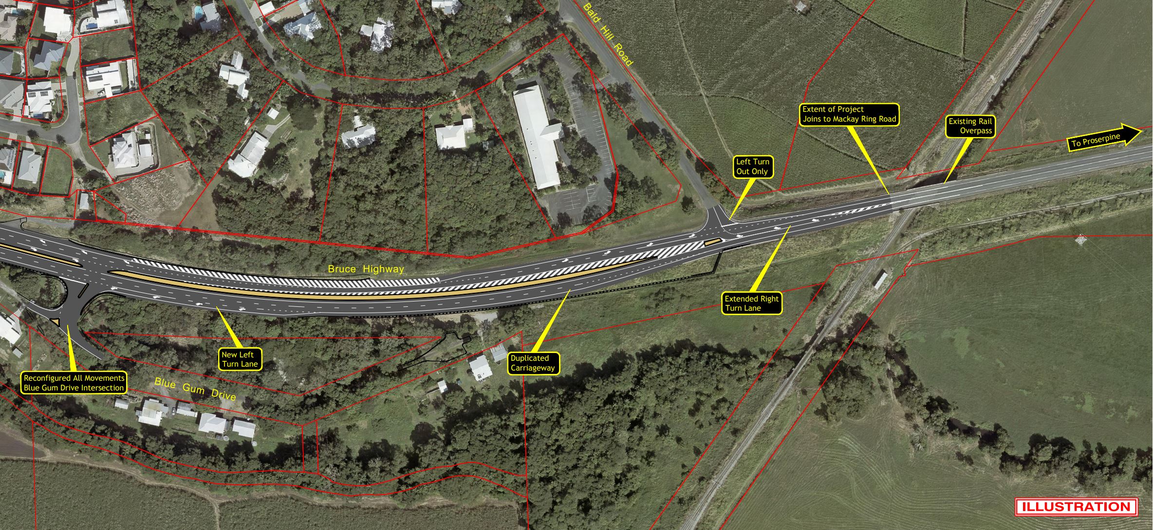
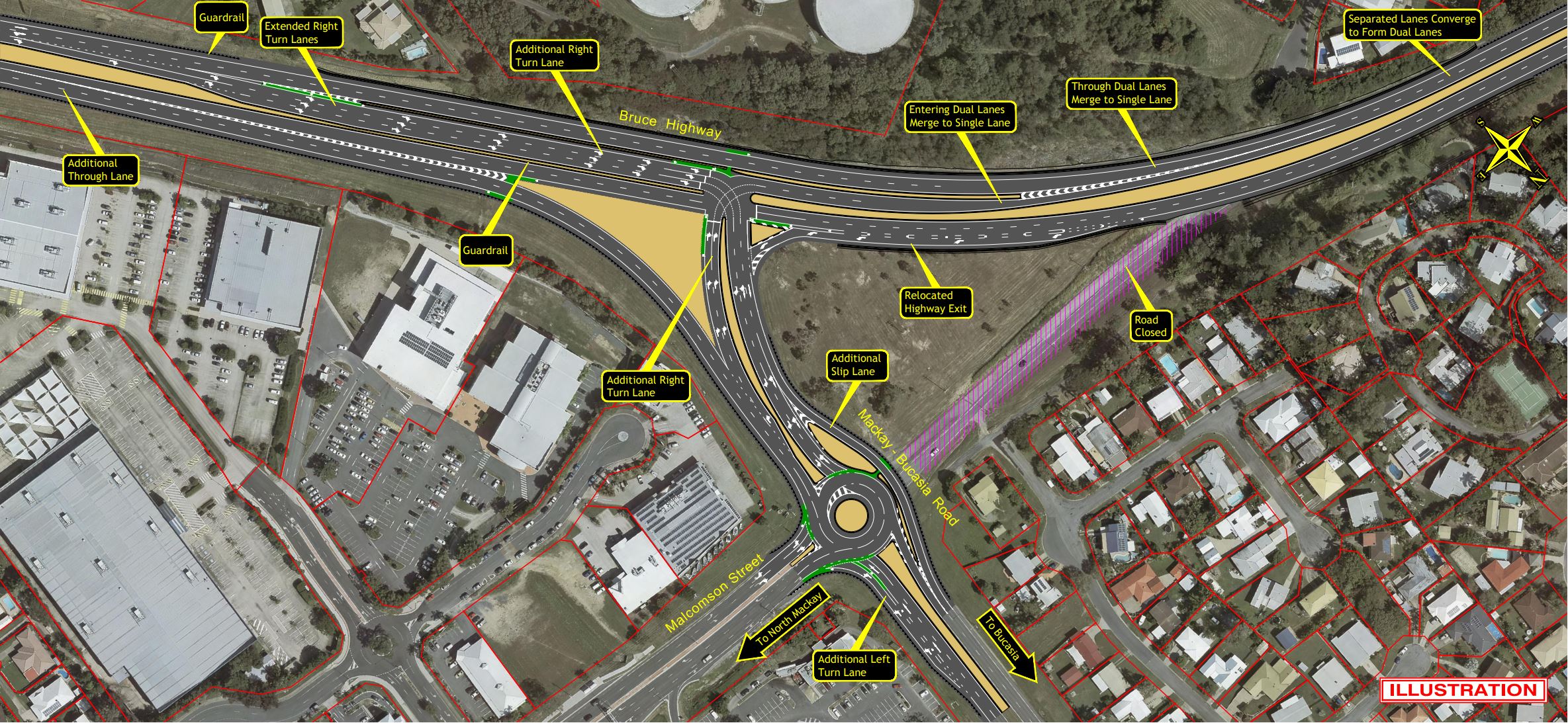
- Increased the Bruce Highway from 4 to 6 lanes from Ron Camm Bridge to the Mackay-Bucasia Road turn off.
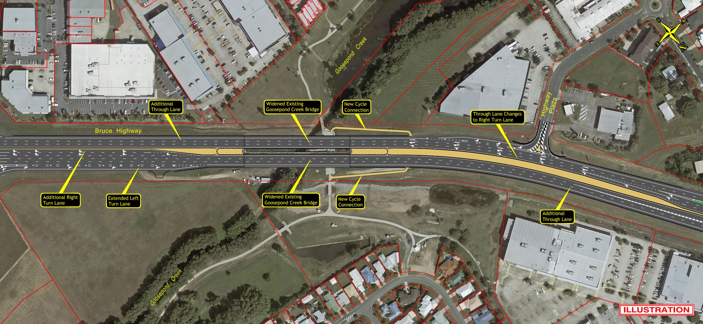
- Widened the Goosepond Creek bridges.
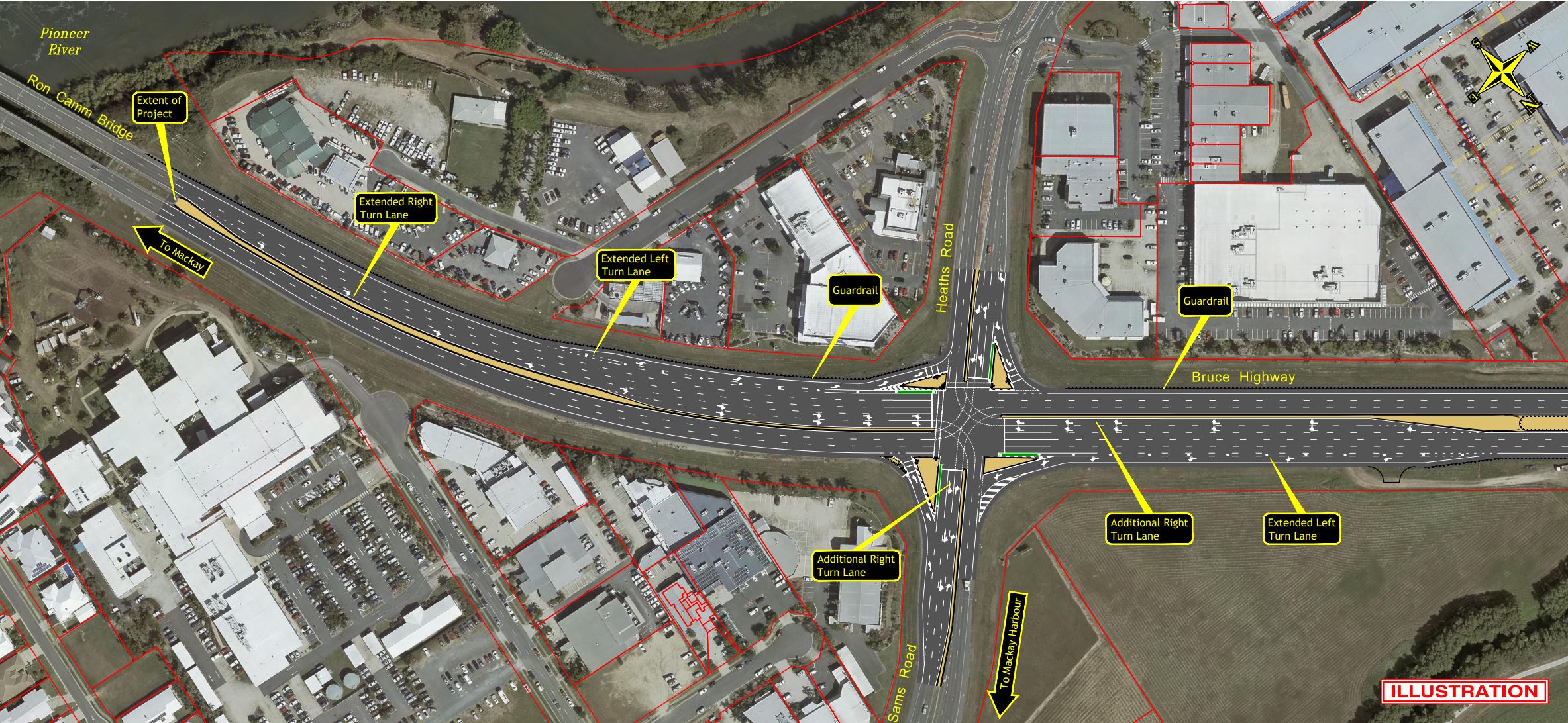
- Extended existing left and right-turn lanes on the approaches to the signalised intersections at Sams Road and Mackay-Bucasia Road.
- Provided an additional right-turn lane at the Mackay-Bucasia Road intersection.
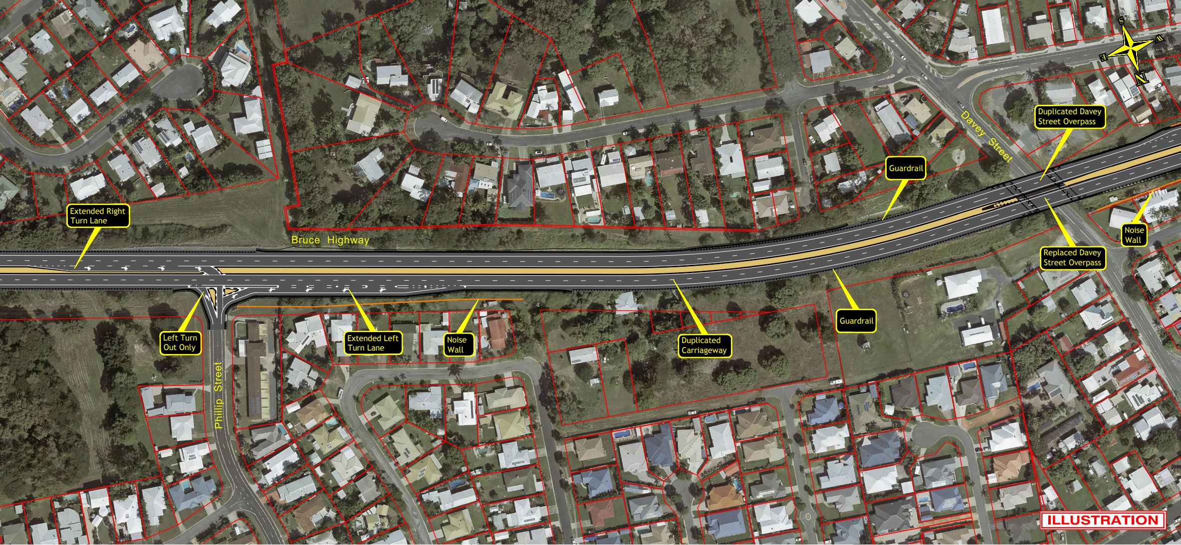
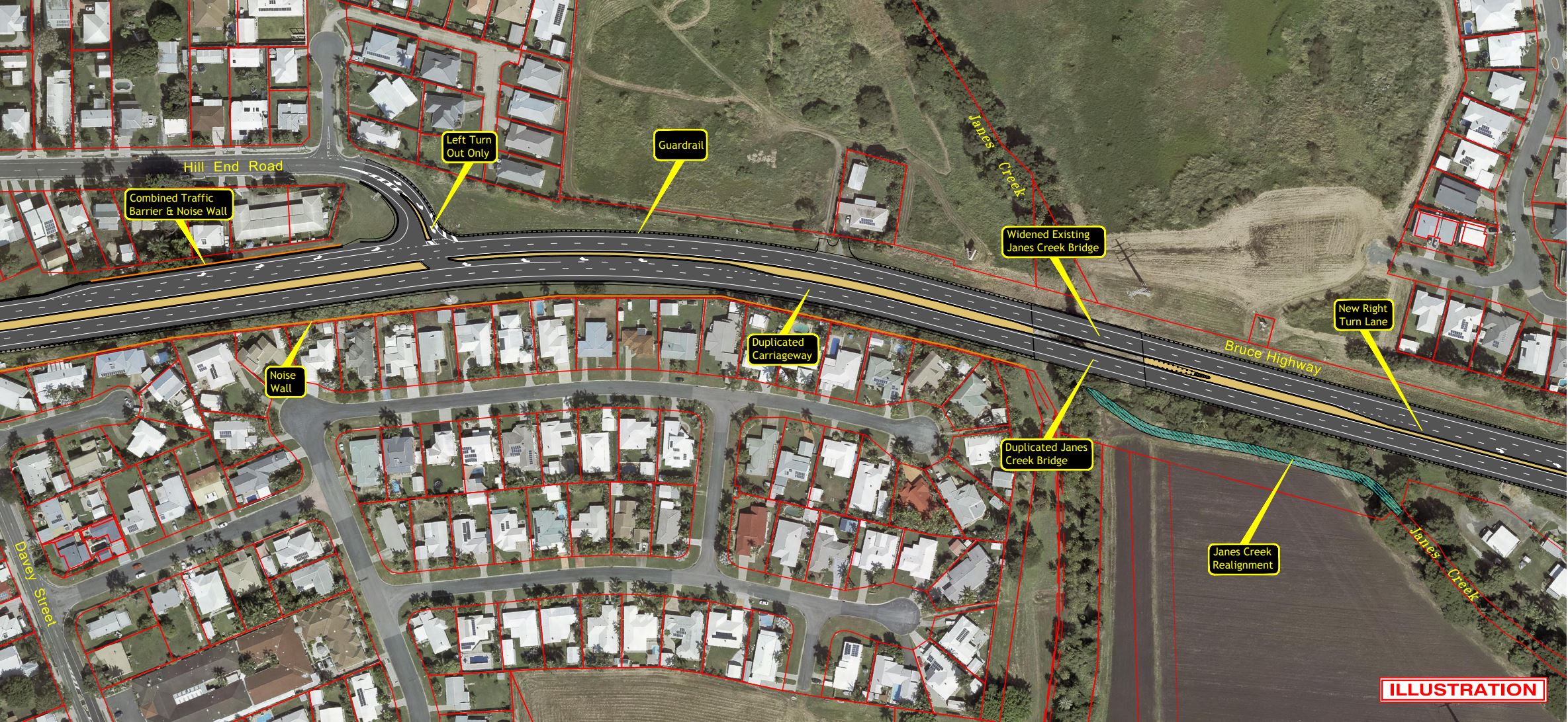
- Provided left-turn options only entering onto the Bruce Highway from Phillip Street, Hill End Road and Bald Hill Road.
- Increased the Bruce Highway from 2 lanes to 4 lanes for through vehicles north from Mackay-Bucasia Road to the Davey Street overpass.
- Constructed new bridge overpasses at Davey Street.
- Upgraded the intersection at Hill End Road.
- Constructed a new bridge at Janes Creek and widen the existing structure.
- Realigned Janes Creek.
- Upgraded the intersection at Blue Gum Drive.
Key milestones
- 2017: geotechnical investigations and detailed design.
- Late 2018: tenders for construction called.
- Late 2019: construction contract awarded.
- March 2020: early works commenced.
- April 2020: construction commenced.
- Late 2020: Janes Creek bridge southbound completed.
- Late 2020: new traffic signals at Sams Road/Heath’s Road intersection completed.
- Mid-2021: widening works on Ron Camm Bridge to Mackay-Bucasia Road completed.
- Mid-2021: Davey Street overpass and demolition of old bridge completed.
- Mid-2022: Goosepond Creek Bridge widening (northbound) completed.
- Late 2022: Goosepond Creek Bridge widening (southbound).
- Late 2022: Janes Creek Bridge widening (northbound).
- October 2022: construction completed.
Funding
This project was jointly funded by the Queensland and Australian governments. Investment ID 10668
- Total investment
- $144.55 million
- Australian Government
- $115.64 million
- Queensland Government
- $28.91 million
Current status
Construction started in April 2020 with CPB Contractors delivering the works. Construction was completed in October 2022.
Positive outcomes for Janes Creek
Janes Creek originates in the hills and cane lands of Farleigh and Richmond around 10km north-west of the CBD of Mackay. The creek changes its name to The Gooseponds downstream of Farleigh. It then passes through the localities of Glenella and Mount Pleasant and eventually joins Vines Creek in North Mackay, which discharges into the Bassett Basin at the mouth of the Pioneer River.
The watercourse is deeply carved with steep banks. During environmental surveys in 2017, a near vertical dry pitched rock was identified on the southern side of the creek bank. As rock walls in nearby Farleigh were found to be of South Sea Islander origin, this dry pitched rock warranted some investigation.
With historical research and stakeholder consultation the dry pitched rock was determined to likely be a form of scour protection constructed more than 50 years ago to protect the adjacent highway.
Construction activities
The Bruce Highway between Janes Creek and Blue Gum Drive was duplicated on the northern side which will require a partial realignment of Janes Creek.
The realigned Janes Creek mimics natural flow conditions and retain channel capacity, while still retaining a similar channel network. Revegetation of the watercourse's riparian environment using local plant species was also undertaken.
The realigned section is 'fish friendly' with the inclusion of fish-accessible structures and the placement of logs and rocks at random locations to provide habitat for fish and other aquatic wildlife.
much of the existing rock at Janes Creek, which was determined to have been a form of scour protection, has been salvaged and reused in the permanent alignment to provide habitat for fish and other aquatic fauna.
Mackay Northern Access Upgrade overview map
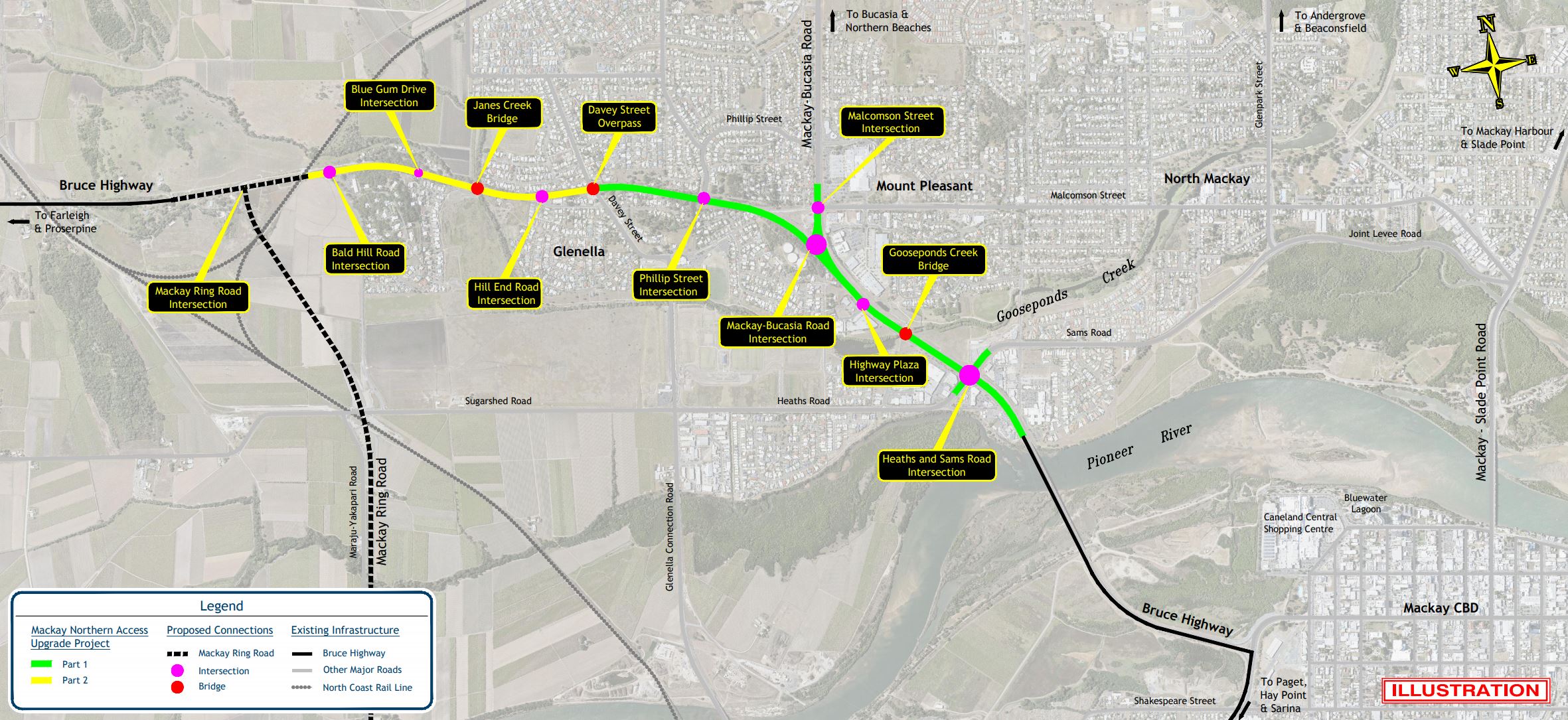
Map 1 – Ron Camm Bridge to North Point Retail
Map 2 – North Point Retail to Greenfields
Map 3 – Greenfields to Phillip Street
Map 4 – Phillip Street to Davey Street Overpass
Map 5 – Davey Street Overpass to Blue Gum Drive
Map 6 – Blue Gum Drive to Mackay Ring Road roundabout