Queensland

334 Projects in Queensland showing 21-40

Filter projects

Filters

Status
Status
Programs
Programs
Type
Type
Reset
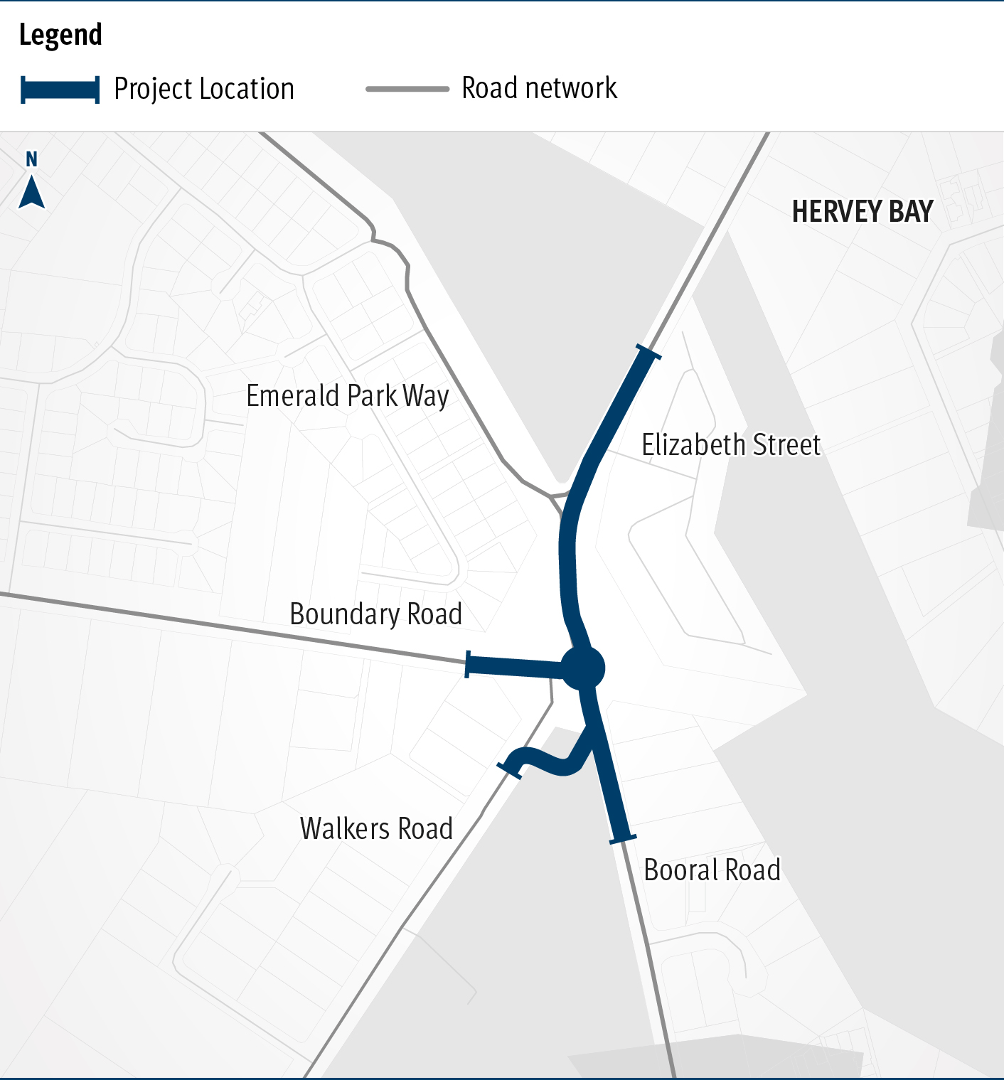
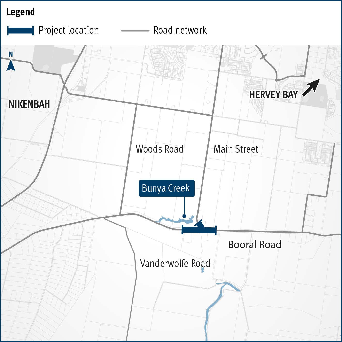
  1. Bicentennial Bikeway, Kurilpa Bridge to Victoria Bridge, design active transport upgrades

    The Bicentennial Bikeway – Kurilpa Bridge to Victoria Bridge upgrade provides an upgraded link for bicycle riders and pedestrians in Brisbane's Central Business District...

    No image supplied
  2. Booral Road and Boundary Road (Urangan), intersection upgrade

    Detailed design is underway for a proposed upgrade of the Booral Road and Boundary Road intersection...

    The map shows the locality of the proposed Booral Road and Boundary Road intersection upgrade. Hervey Bay is located north-east of the project location. A solid blue line indicates the project extent, which encompasses the Booral Road and Boundary Road intersection, and also extends along Booral Road to the north past the Emerald Park Way intersection and to the south along Booral Road past the proposed new Walkers Road intersection. Walkers Road has been realigned to access Booral Road to the south of the Booral Road and Boundary Road intersection. The local road network, including where Booral Road turns into Elizabeth Street, is also highlighted on the map.
  3. Booral Road, Bunya Creek floodway and Main Street intersection upgrade, planning

    Planning is underway to improve flood immunity and safety on a section of Booral Road at Bunya Creek, including the Main Street intersection...

    Alternative text: The map shows the locality of the proposed Booral Road, Bunya Creek floodway and Main Street intersection upgrade. Nikenbah is located to the north and Hervey Bay to the north-east. Bunya Creek is located just north west of the proposed project location. A solid dark blue line indicates the project extent, which encompasses the Booral Road and Main Street intersection as well as the Bunya Creek floodway along Booral Road, which is located just west of the intersection. The local road network, including Woods Road and Vanderwolfe Road are also highlighted on the map.
  4. Boundary Road (Coopers Plains), rail level crossing, funding commitment

    We are completing a business case to investigate options to reduce congestion and address safety concerns at Boundary Road, Coopers Plains rail level crossing...

    Boundary Road Coopers Plains Rail Crossing map
  5. Bribie Island and surrounds transport and mobility study

    Bribie Island and Surrounds Transport and Mobility Study...

    No image supplied
  6. Brisbane Metro – Woolloongabba Station

    Planning is underway for the Brisbane Metro – Woolloongabba Station project to enhance access to public transport, improve transport connectivity and manage increasing demand on the South East Busway...

    No image supplied
  7. Brisbane Valley Highway (Ipswich – Harlin), Fernvale, upgrade pedestrian facilities

    Fernvale township safety treatments new pedestrian crossing and right-turn lanes...

    No image supplied
  8. Brisbane to Sunshine Coast Rail Corridor Strategy

    The department is developing a strategy for future rail projects between Brisbane and Gympie North...

    No image supplied
  9. Brisbane–Beenleigh Road, Loganlea Road to Waterford–Tamborine Road, business case

    The department is undertaking a business case for a potential future project on Brisbane–Beenleigh Road, between the intersections of Loganlea Road and Waterford–Tamborine Road. The community is...

    No image supplied
  10. Bruce Highway (Ayr - Townsville), Killymoon Creek to Townsville Port Road, improve intersection

    The upgrades to the Bruce Highway intersections at Allendale Drive, Three Sisters Drive, and Muntalunga Drive have successfully been completed...

  11. Bruce Highway (Bowen – Ayr), Bowen Connection Road to Champion Street intersection, widen pavement

    The project will deliver safety upgrades to almost 6 kilometres of the Bruce Highway between the Bowen Connection Road and Champion Street intersections. Additionally, the Bruce Highway and Don Street...

    No image supplied
  12. Bruce Highway (Bowen – Ayr), construct overtaking lanes

    The Bruce Highway (Bowen – Ayr) overtaking lanes are being delivered as part of the Bruce Highway Upgrade Program, a $13 billion, 15-year program of works aimed at improving safety, flood resilience...

    No image supplied
  13. Bruce Highway (Bowen-Ayr), Inkerman overtaking lane and safety improvement projects

    Construction of a new northbound overtaking lane on the Bruce Highway at Fredericksfield and upgrades to the intersection with Mount Inkerman Road...

    No image supplied
  14. Bruce Highway (Brisbane - Gympie), Anzac Avenue to Uhlmann Road upgrade, business case

    The department is undertaking a planning study to upgrade the Bruce Highway from 6 to 8 lanes from Anzac Avenue to Uhlmann Road...

    Aerial view of Anzac Avenue to Uhlmann Road
  15. Bruce Highway (Brisbane - Gympie), Caboolture - Bribie Island Road to Steve Irwin Way upgrade

    We are upgrading the Bruce Highway to 6-lanes between Caboolture-Bribie Island Road and Steve Irwin Way (Exit 163)...

    No image supplied
  16. Bruce Highway (Cooroy to Curra) Section D

    The $1 billion Section D: Woondum to Curra (C2CD) project is a new 26km, 4-lane divided highway between the existing Bruce Highway interchange at Woondum, south of Gympie and Curra...

    Deep Creek bridges looking south west