
Nerang-Murwillumbah Road, safety treatments
This project is focused on improving safety along various sections of this 36km road where there is a high crash history.
Nerang-Murwillumbah Road high risk road project
The first package of safety improvements are ongoing and include:
- wide centre line marking from Beaudesert–Nerang Road to Tangara Road
- channelised right turns into:
- Parkway Drive
- Latimers Crossing Road
- Tangara Road
- the access road into the Gilston Advancetown Rural Fire Brigade
- pavement widening and sealing
- installation/modification of existing safety barriers (including motorcycle underrun protection)
- vegetation clearing (to increase sight distance)
- installation/modification of existing warning signage and line marking
- pullover bays for the Queensland Police Service to monitor traffic.
In June 2023, the second package of safety improvements commenced, including:
- Pine Creek Road intersection: pavement widening, channelised right turn lane, auxiliary left turn lane, guardrail, signage and line marking, drainage improvement works and batter treatments.
- Narrowleaf Road intersection: channelised right turn lane, pavement widening, guardrail, signage, line marking, drainage improvement works and batter treatments.
- Bochow Park intersection: pavement widening, guardrail, signage, line marking, drainage improvement works and batter treatments.
- Pavement widening, guardrail, signage and line marking, drainage improvement works and batter treatments at various locations.
- Installation of a new Queensland Police Service pullover bay near Pine Creek Road taking the total number to 11.
- Whole-of-road corridor treatment: installing road edge guide posts.
Benefits
- Improves safety
Funding
Investment ID 1390056
- Total investment
- $41 million
- Queensland Government
- $41 million
Project completion time frames 2023–2024
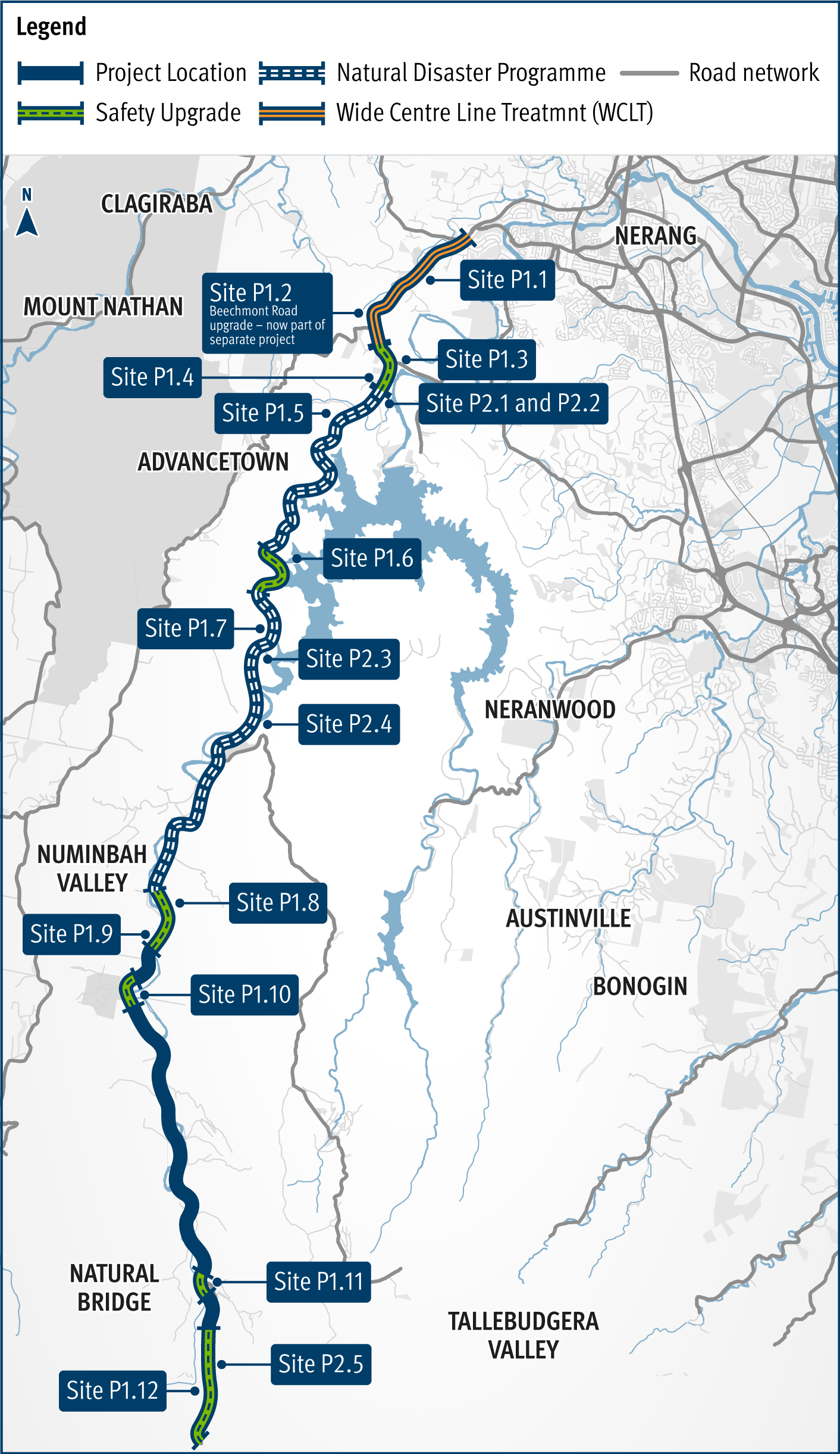
The following tables detail the site works and completion date for package 1 and package 2 works. These site works are indicated on the project map.
Package 1 works
| Works | Completion date |
| Site P1.1 Clagiriba Road intersection: Pavement widening, channelised right turn lane, guardrail, signage, line marking, drainage improvement works and batter treatments | Major works have been completed. Minor works to be finalised |
| Site P1.2: Beechmont Road upgrade is part of a separate project | Completed |
| Site P1.3 Parkway Drive intersection & Latimers Crossing Road intersection: Pavement widening, channelised right turn lanes, auxiliary left turn lanes, guardrail, signage, line marking, drainage improvement works and batter treatments | Completed |
| Site P1.4 - Tangara Road intersection: Pavement widening, channelised right turn lane, guardrail, signage, line marking, drainage improvement works and batter treatments |
Major works have been completed. Minor works to be finalised |
| Site P1.5: Pavement widening, guardrail, signage, and line marking |
Major works have been completed. Minor works to be finalised |
| Site P1.6: Pavement widening, guardrail, signage, and line marking |
Major works have been completed. Minor works to be finalised. |
| Site P1.7: Pavement widening, guardrail, signage, and line marking. Completion mid-2024 |
Completion mid-2024 |
| Site P1.8: Driveway upgrades, pavement widening, guardrail, signage, line marking, and drainage improvement works |
Completed |
| Site P1.9: Driveway upgrades, pavement widening, guardrail, signage, line marking, and drainage improvement works |
Completed |
| Site P1.10: Driveway upgrades, signage, and line marking |
Completed |
| Site P1.11: Driveway upgrades, signage, and line marking | Completed |
| Site P1.12: Driveway upgrades, signage, line marking and hazard removal |
Completed |
Package 2 works
| Works | Completion date |
| Narrowleaf Road intersection: Pavement widening, channelised right turn lane, guardrail, signage and line marking, drainage improvement works and batter treatments |
Completion late-2023 |
| Pine Creek Road intersection: Pavement widening, channelised right turn lane, auxiliary left turn lane, guardrail, signage and line marking, drainage improvement works and batter treatments |
Completion late-2023 |
| Bochow Park intersection: Pavement widening, guardrail, signage and line marking, drainage improvement works and batter treatments |
Completion mid-2024 |
| Site P2.1: Pavement widening |
Completion late-2023 |
| Site P2.2: Pavement widening |
Completion late-2023 |
| Site P2.3: Pavement widening |
Completion late-2023 |
| Site P2.4: 10 Queensland Police Service pullover bays have been installed and site P2.4 is the final one to be installed. |
Completion late-2023 |
| Site P2.5: Pavement widening, guard-rail, signage and line marking, drainage improvement works and batter treatments |
Completion mid-2024 |
| Whole of corridor treatment: Road edge guide posts |
Completion mid-2024 |
Project map
Construction started in May 2021 and is expected to continue until mid-2024.
The community is invited to subscribe to free email and text alerts to remain informed about the safety improvement works on Nerang–Murwillumbah Road. To register for these services, or to find out more about the safety improvement project, please contact the project team.
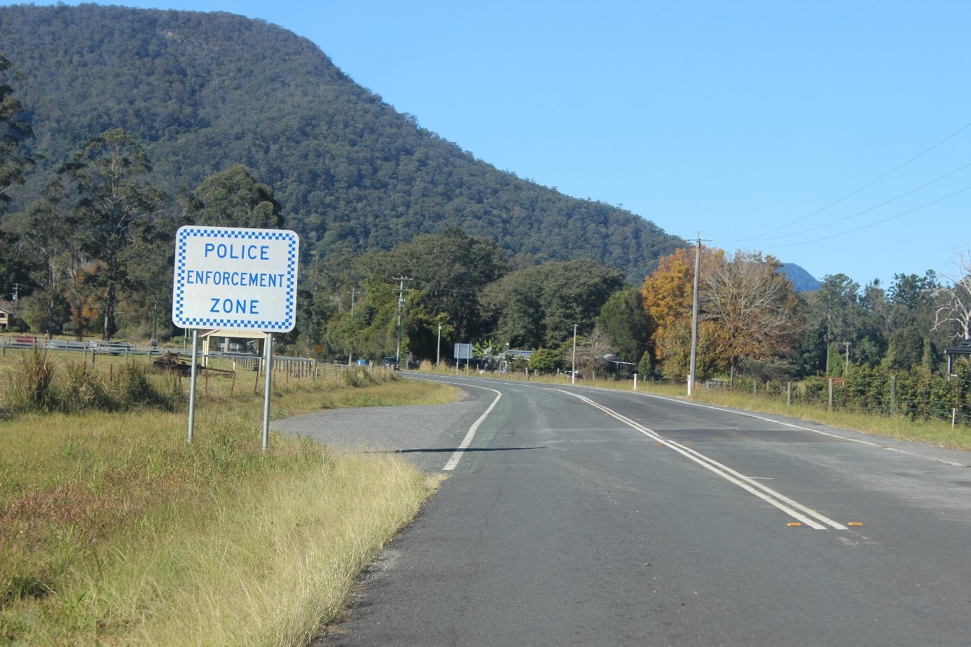
Queensland Police Service enforcement bay at Numinbah Valley