
Case study: South East Queensland – Gateway Upgrade North
 This case study showcases the South East Queensland – Gateway Upgrade North as an effective implementation of the Cycling Infrastructure Policy. Information and figures presented in this case study are correct at July 2019 unless indicated otherwise.
The Gateway Upgrade North project involved the widening of the Gateway Motorway, located north east of Brisbane’s city centre, from 4 to 6 lanes between Nudgee and Deagon.
Construction was completed in early 2019, with the shared pathway officially opened in March 2019. This $1.143 billion project was jointly funded by the Australian and Queensland governments.
The Cycling Infrastructure Policy required the provision of active transport facilities during design and construction.
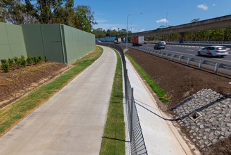
A 3.5m wide off-road shared pedestrian and bicycle riding path was constructed along the length of the project, with connections to existing local bicycle and pedestrian networks.
Over 15km of new and upgraded pathway was constructed, including connections to the Jim Soorley Bikeway at Nudgee and the existing Gateway Motorway pedestrian/cyclist underpass at Bracken Ridge.


The path connects to local networks at several locations including:
- Nudgee Road interchange, Nudgee
- Bicentennial Road interchange and Boondall Wetlands, Boondall
- Sandgate Road, and North Boondall Station, Boondall
- Blackwood Road, Deagon
- Muller Road and Egret Place, Taigum
- Depot Road, Deagon
- Childs Street, Carl Place, Barrett Street, Woodcroft Street, John Fisher Drive and the Deagon Deviation bikeway via Barfoot Street, Bracken Ridge.
The Gateway Upgrade North project has significantly improved active transport infrastructure for pedestrians and bicycle riders and provides safe-off road connections for travel to and from the north side of Brisbane.
 A key element of the project’s design was to enable pedestrian/bicycle rider connectivity along the full length of the project. This is achieved via new or upgraded underpasses, accesses and separated pathways on bridge structures, including:
- under Nudgee Road and over the Gateway Motorway at Nudgee
- over Nundah Creek at Nudgee
- over Sandgate Road and the Shorncliffe rail line at Deagon
- under the Deagon Deviation at Sandgate
- under Depot Road (by BCC).
During construction, access for pedestrians and bicycle riders was maintained through:
- pathway diversions via existing and temporary shared paths and local streets
- temporary underpasses through bridge construction sites, using modified shipping containers
- signage advising of changes, including directional signage
- installation of temporary fencing and gravel paths
- pathways operating under traffic control.
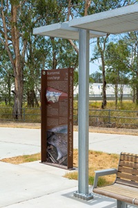
Five covered rest areas have been provided along the new pathway. These facilities include lighting, seating and water stations for people and pets (at 2 locations), providing an opportunity for pathway users to rest and enjoy the natural surrounds.
For guidance on navigating the pathway, please download the GUN shared pathway information sheet.

- Last updated
- 26 June 2026