
North West Queensland Regional Roads and Transport Group
On this page:
- Project story: Burke Shire Council, Beacon Pile Gully, Truganini Road (approximately 3km north east of Burketown) – culvert replacement and upgrade
- Project story: Carpentaria Shire Council, Poingdestre Creek, Normanton – Burketown Road (approximately 88km south west of Normanton), causeway widening
- Project story: Cloncurry Shire Council, Coppermine Creek Bridge, Sheaffe Street, Cloncurry (between Short and McKinlay Streets), bridge replacement
- Regional Roads and Transport Group members
- North West Queensland Regional Roads and Transport Group map
- Transport Infrastructure Development Scheme (TIDS) program details
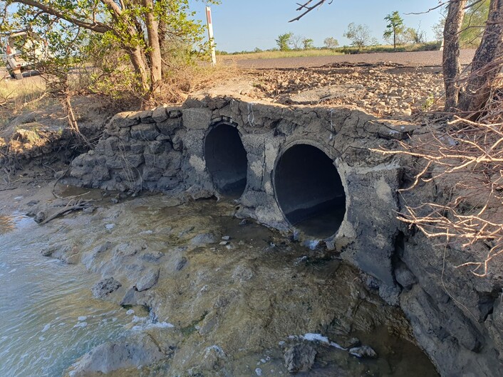
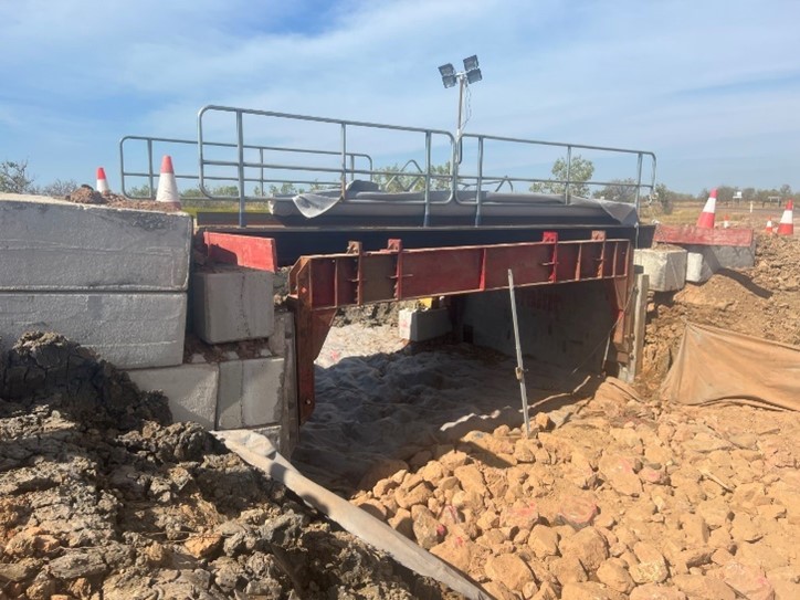
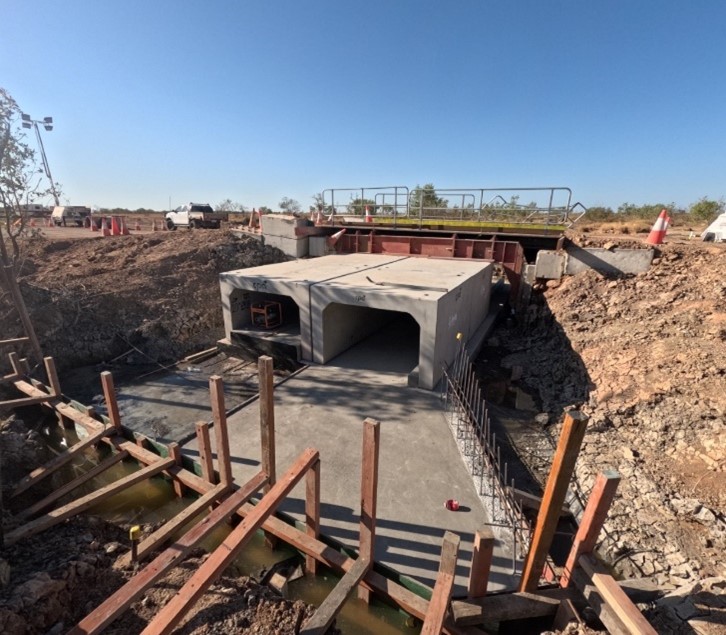
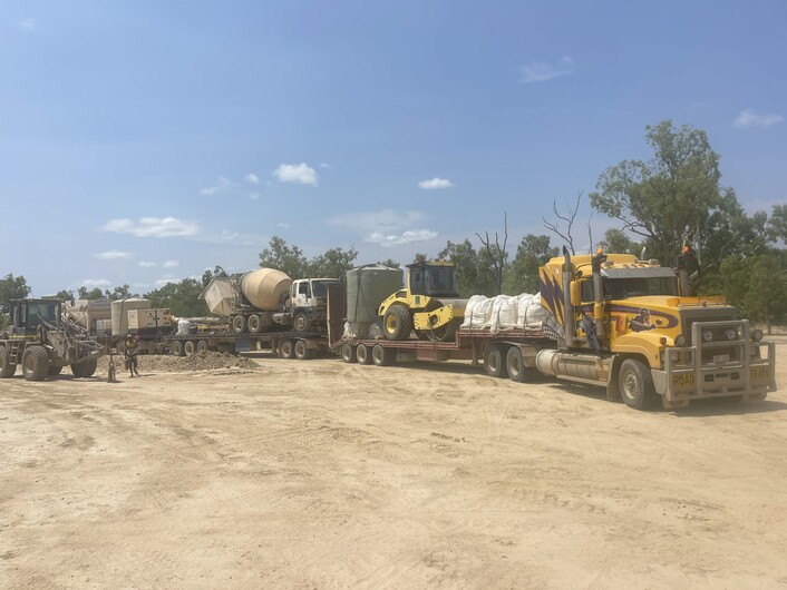
Project story: Burke Shire Council, Beacon Pile Gully, Truganini Road (approximately 3km north east of Burketown) – culvert replacement and upgrade
Submitted by Amir Akrami, Manager Project Management Office, Burke Shire Council.
Truganini Road, a council-controlled Local Road of Regional Significance, provides critical access to the Albert River wharf from Burketown and is the only available road to the boat ramp. The road traverses low-lying tidal flats at Beacon Pile Gully, the site of the culvert replacement.
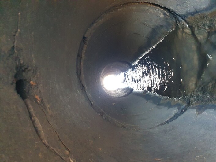
The old twin 800mm diameter concrete pipes were severely damaged and unsafe for motorists.
An urgent upgrade was required. Accordingly, new compliant reinforced concrete box culverts (twin 1800mm x 1200mm) were installed within the 2024–25 North West Queensland (NWQ) RRTG works program to achieve the following objectives:
- reduce disaster risk and increase Burketown disaster resilience
- improve drainage capacity
- improve fish passage
- minimise the impacts of road closures and access to the critically important Truganini Road Barge and Boat Ramp which significantly benefits the community of Burke Shire Council including:
- transportation of supplies (medical /food etc) during the wet season
- maintaining fishing activities on the Albert River that supports numerous local businesses (Burketown is known as the “Barramundi capital of the world”).
Funding was also received from Queensland Reconstruction Authority’s Queensland Resilience and Risk Reduction Fund to enable the project to proceed.
Due to specific requirements from key stakeholders, the works were undertaken in stages to minimise the impact to traffic. A temporary elevated sidetrack over the construction site was installed to allow the culvert base slab and half the crown units to be placed, under live traffic. Traffic was then diverted over the new culvert crown units to allow the balance of works to be constructed under a single lane operation.
Being a tidal waterway, the site presented additional challenges including marine subgrade, tidal flows and marine vegetation. Care was taken in the design and construction to minimise disruption to the natural environment. The design incorporated a low flow channel with baffles to promote fish passage. The existing channel beyond the scope of works was reinstated to its pre-works condition.
The successful delivery of the project was made possible through the collaborative efforts of council’s engineering team and Northlane Engineering Consultants. Northlane not only completed the detailed design but also played a key role in managing the project through to completion.
One of the major challenges encountered during the project was stakeholder management. However, through the implementation of a robust and proactive engagement strategy, the project team was able to navigate complex stakeholder expectations and concerns effectively.
The outcome was met with positive feedback from the community, reflecting both the quality of the final product and the strength of the team’s communication and coordination efforts throughout the project lifecycle.
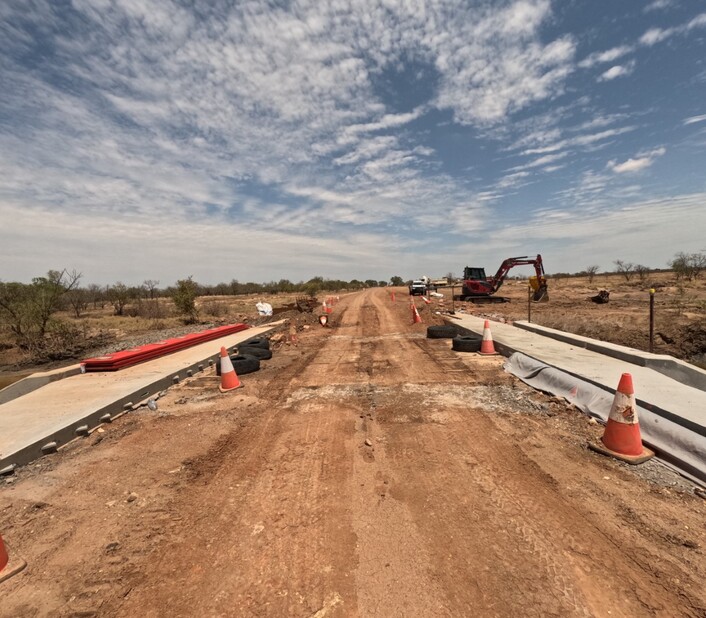
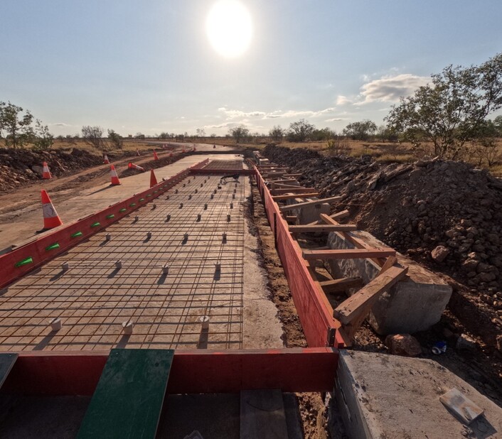
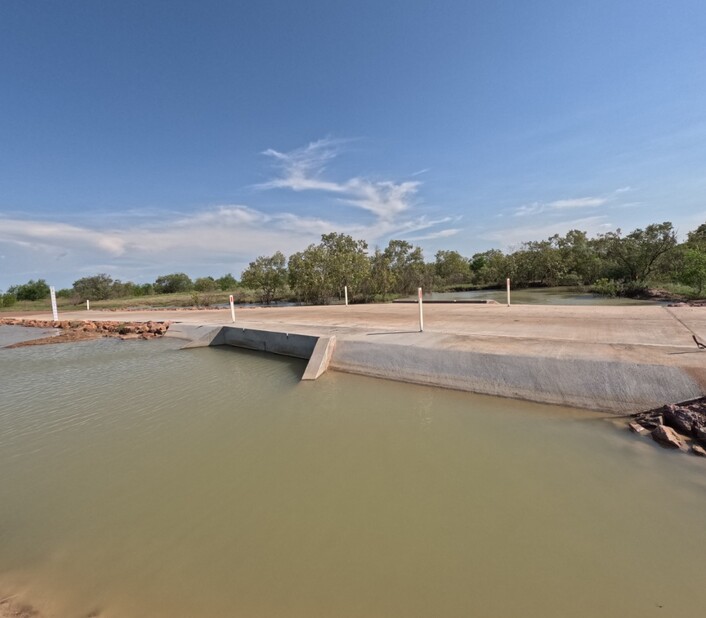
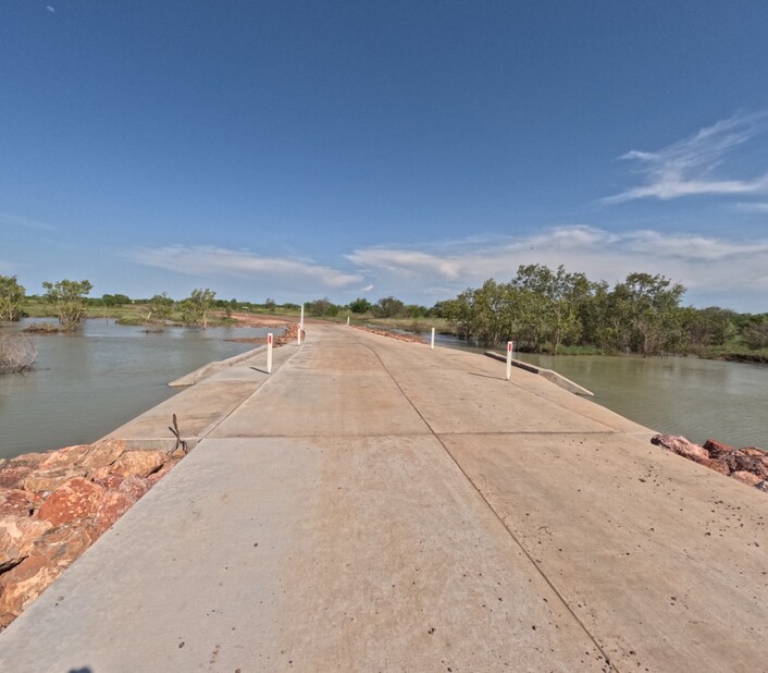
Project story: Carpentaria Shire Council, Poingdestre Creek, Normanton – Burketown Road (approximately 88km south west of Normanton), causeway widening
Submitted by Michael Wanrooy, Director of Engineering, Carpentaria Shire Council.
Back in 1876, police Sub-Inspector L. Poingdestre described the road coming into Normanton as a very dangerous one for travelling. He had under his command two constables and 10 troopers which is coincidently roughly the same numbers of duty police officers currently residing in Normanton.
Prior to the upgrade, Poingdestre Creek matched the sub-inspector’s description quite well as this was an uncomfortable crossing to negotiate for vehicles. There is a major creek a few miles east of Poingdestre Creek and is named L Creek. Both creeks were named after him and as yarns go, he is remembered by locals today as the man with the reputation of shooting first and quick to throw a fist. The reputation of the man oddly enough matches the meaning of his surname of French origin meaning “right fist”.
Poingdestre Creek is located on the Normanton to Burketown Road which is a high priority council-controlled Local Road of Regional Significance and is part of the Flinders River catchment. The river was named after Matthew Flinders who explored the Gulf of Carpentaria in 1802, after his recorded disappointment of not finding a river in the Spencer Gulf, South Australia. The loneliest mail run, covered by boat using only maps and charts drawn up by Matthew Flinders, delivered mail to crocodile hunters whom were plentiful in the ‘20s and ‘30s and isolated mission stations and settlements by landing at river mouths along the Gulf stretching from Normanton to Burketown and up to Darwin
Poingdestre Creek had an existing narrow 5m wide concrete causeway constructed between two bends. This followed the design philosophy back in the day to make the crossing more perpendicular with the creek resulting with bends at each approach. There was evidence of vehicles skidding off the gravel surface towards the table drain, despite signage, as they negotiate the turn and suddenly notice the narrow causeway causing driving overcorrection.
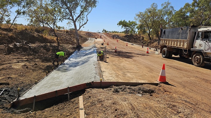
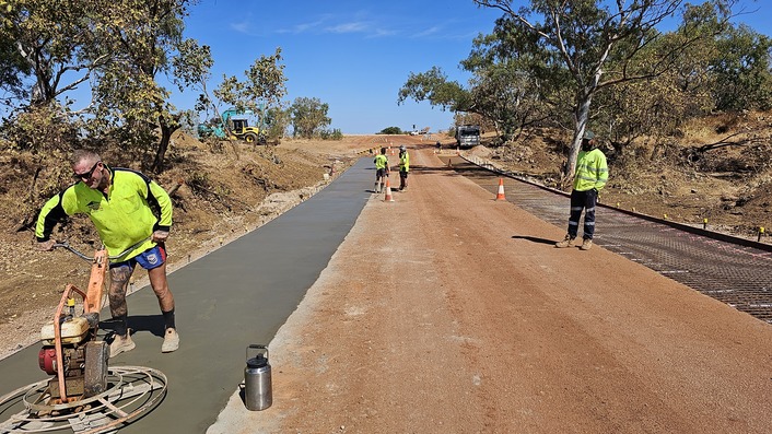
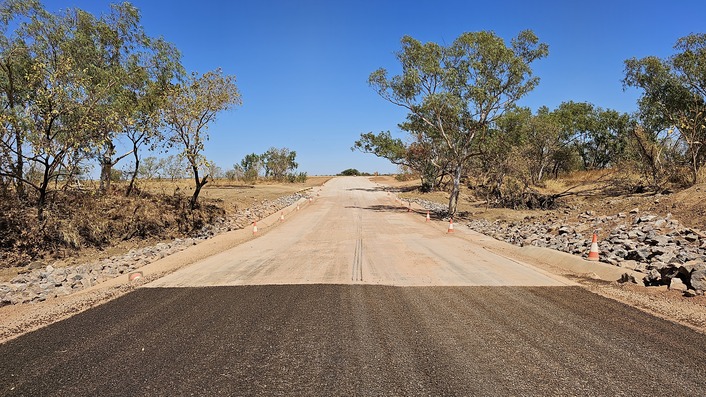
Council received betterment funding to seal both approaches to the creek and there were concerns that vehicles would now comfortably travel at higher speeds increasing the risk of potential accidents at the creek. To mitigate and minimise this risk and improve safety, funding was allocated within the 2024–25 NWQRRTG works program to widen the existing causeway to allow for a 9m formation. The new widening will allow triple road trains and caravans to pass each other with sufficient room. Both projects were completed concurrently. A mobile batching plant was brought to site to deliver the works.
Council also constructed seven concrete floodways and resealed 14.65km on the Normanton to Burketown Road within the 2024-25 NWQRRTG works program.
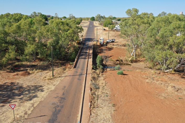
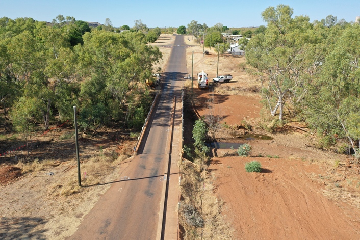
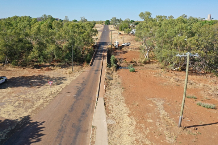
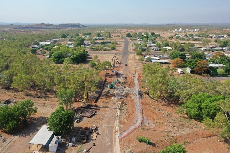
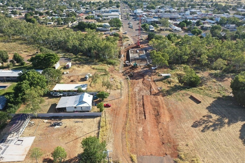
Project story: Cloncurry Shire Council, Coppermine Creek Bridge, Sheaffe Street, Cloncurry (between Short and McKinlay Streets), bridge replacement
Submitted by Gerard Read, on behalf of Cloncurry Shire Council.
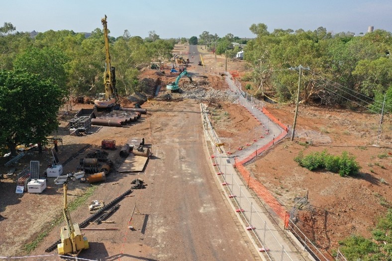
The Coppermine Creek Bridge replacement on Sheaffe Street is a transformative infrastructure project for Cloncurry, significantly enhancing road safety, including pedestrian and cyclist access and was delivered within the 2024–25 NWQRRTG works program. Located in Cloncurry’s central transport corridor, the project replaces a narrow single-lane crossing with a modern dual-lane bridge and a dedicated 3m pedestrian and cycle path.
The project was funded through a partnership between all levels of government with $5 million from the Australian Government's Bridges Renewal Program and
$4.66 million from council revenue, along with the TIDS contribution.
Construction was awarded to Davbridge Constructions in July 2024. Works are nearing completion, and the bridge is scheduled to re-open in September.
Key features of the project include:
- a new 14.15m wide dual-lane bridge designed for improved flood resilience which featured a 40m span (approximately) on 16 piled foundations
- a 3m wide shared-use path for pedestrians and cyclists
- enhanced surface drainage and lighting to improve safety and urban amenity.
The upgraded bridge delivers year-round, reliable access between the northern and southern sides of Cloncurry – vital for students, healthcare access, freight, and emergency services. The upgraded bridge will improve safety and accessibility for all users.
Project delivery highlights include:
- efficient demolition of the old structure with well-planned detours
- a temporary pedestrian bridge ensured access was maintained during construction
- coordination through regional technical forums with active involvement from council and delivery
Strategic investment
This project is part of council’s broader $41.4 million infrastructure program for
2024–25, reflecting a strong commitment to building safer, more resilient communities through strategic investment in essential infrastructure.
Regional Roads and Transport Group members
- Burke Shire Council
- Carpentaria Shire Council
- Cloncurry Shire Council
- Doomadgee Aboriginal Shire Council
- Flinders Shire Council
- Kowanyama Aboriginal Shire Council
- McKinlay Shire Council
- Mornington Shire Council
- Mount Isa City Council
- Richmond Shire Council
- TMR North West District
Chair: Councillor John Wharton, Mayor, Richmond Shire Council
Deputy Chair: Councillor Greg Campbell, Mayor, Cloncurry Shire Council
Technical Committee Chair: Michael Wanrooy, Carpentaria Shire Council
Technical Committee Deputy Chair: Amir Akrami, Burke Shire Council
Technical Coordinator: Gerard Read, GWR Civil Engineering Management
Transport Infrastructure Development Scheme (TIDS) 2024-25 Allocation: $5,168,901
Aboriginal and Torres Strait Islander TIDS 2024-25 allocation: $666,651
Total number of projects: 23
North West Queensland Regional Roads and Transport Group map.
North West Queensland Regional Roads and Transport Group (RRTG) Transport Infrastructure Development Scheme (TIDS) program details
The following information lists the RRTG TIDS 2024–25 works program by local government, with the project name and the year-to-date TIDS expenditure.
Burke Shire Council
| Project name | Expenditure |
|---|---|
|
Floraville Road and Truganini Road, upgrade culverts |
$512,610 |
|
Beames Street, Macintyre Street - Truganini Road, improve drainage |
$50,000 |
|
Burketown, various roads, reseals |
$177,390 |
Carpentaria Shire Council
| Project name | Expenditure |
|---|---|
|
Burketown Road, reseal |
$250,000 |
|
Burketown Road, construct floodways and culverts |
$300,000 |
|
Burketown Road, Poingdestre Creek, widen floodway |
$350,000 |
Cloncurry Shire Council
| Project name | Expenditure |
|---|---|
|
Sheaffe Street, Coppermine Creek, replace bridge |
$489,999 |
Doomadgee Aboriginal Shire Council
| Project name | Expenditure |
|---|---|
|
Various outstation access roads, re-sheet gravel |
$206,791 |
Flinders Shire Council
| Project name | Expenditure |
|---|---|
|
Various roads, install or replace floodways |
$301,000 |
|
Hughenden - Muttaburra Road, construct to a sealed standard |
$428,955 |
|
Old Richmond Road, form and seal |
$440,000 |
Kowanyama Aboriginal Shire Council
| Project name | Expenditure |
|---|---|
|
Dunbar - Kowanyama Road, resheet unsealed road |
$459,860 |
McKinlay Shire Council
| Project name | Expenditure |
|---|---|
|
Byrimine Road, construct to a sealed standard |
$200,000 |
|
Punchbowl Road, construct to a new sealed standard |
$308,125 |
Mornington Shire Council
| Project name | Expenditure |
|---|---|
|
Ballaleah Road (17.50km), construct floodway |
$384,403 |
Mount Isa City Council
| Project name | Expenditure |
|---|---|
|
Tharrapatha Way, Alma Street to Davis Road, upgrade culverts |
$334,727 |
|
Riversleigh Road, form and improve drainage |
$50,903 |
|
Lake Moondarra Road (Section 2), reseal |
$72,120 |
Richmond Shire Council
| Project name | Expenditure |
|---|---|
|
North West RRTG, secretariat administration |
$137,071 |
|
Maxwelton - Frontage Road, various locations, rehabilitate and widen |
$286,170 |
|
Coalbrooke Road, various locations, gravel sheeting |
$250,000 |
|
Maxwelton - Frontage Road, construct to new sealed standard |
$188,109 |
|
Villadale Road, various locations, resheet gravel |
$41,721 |
- Last updated
- 17 October 2025