
Mareeba – Dimbulah Road, Mareeba Heavy Vehicle Bypass, planning
This project will progress planning for the southern section of the Mareeba Bypass and review the alignment of the northern section.
Mareeba is located approximately 60km to the west of Cairns in Far North Queensland and sits at a crossroads of the Mareeba - Dimbulah Road, Mulligan Highway and Kennedy Highway. All through traffic, including heavy vehicles, need to travel via Mareeba's main street Byrnes Street (the local name for Mareeba – Dimbulah Road).
In 2018, the department completed planning for the northern section of the Mareeba Bypass.
The current planning project will look at the full bypass; it will progress planning for the southern section and review and confirm the alignment of the northern section.
Construction of the bypass is currently unfunded.
Benefits
- Improves safety
- Increases capacity
- Improves network efficiency
- Increases traffic flow
- Reduces peak hour congestion
- Reduces travel time
- Contributes to economy
- Contributes to regional growth
- Improves ride quality
Key features
- Confirm the alignment of the full bypass.
- Identify a viable delivery strategy for the bypass.
Funding
This project is fully funded by the Queensland Government under the Transport System Planning Program. Investment ID 2218324
- Total investment
- $2.2 million
- Queensland Government
- $2.2 million
Current status
We have started planning for the full Mareeba Bypass.
Community consultation
Community consultation took place between January and February 2023.
113 people completed the survey and 25 comments were made.
Feedback about Byrnes Street
- 79.3% want Byrnes Street to remain 2 lanes in each direction.
- 67% strongly agree that Byrnes Street is a bottle neck for heavy vehicles.
- 28.8% of respondents feel safe when crossing Byrnes Street as a pedestrian.
Feedback about the proposed bypass
- 80.5% believe the bypass will reduce the number of heavy vehicles on Byrnes Street.
- 80.2% strongly support the bypass.
- 77.9% believe the bypass will reduce noise, vibration and air pollution on Byrnes Street.
- 76.9% strongly agree that the bypass will improve safety on Byrnes Street.
- 63.4% strongly agree that the bypass will provide opportunities to make Byrnes Street more appealing.
- 16.1% strongly agree that the bypass will negatively impact trade of businesses in Mareeba's CBD.
Various responses mentioned concerns about property impacts relating to the bypass: resumptions, noise during construction, traffic noise and the removal of vegetation.
In general, the proposed location of the bypass on the western side of Mareeba is supported.
This feedback will be used to inform the planning outcomes.
Mareeba – Dimbulah Road, Mareeba Bypass project location map
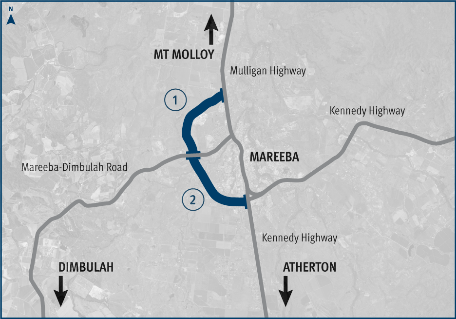
- Northern section of the proposed Mareeba heavy vehicle bypass.
- Southern section of the proposed Mareeba heavy vehicle bypass.