
Beams Road (Carseldine and Fitzgibbon), upgrade rail level crossing
The Beams Road rail level crossing project will reduce congestion and address safety concerns. The current rail level crossing on Beams Road will be replaced with an overpass to separate road and rail.
Beams Road is an important local road that connects communities in the northern suburbs of Brisbane. It currently experiences significant congestion at the rail level crossing, particularly during peak hours.
An overpass upgrade to the rail level crossing will:
- improve travel times and reliability for rail and road users
- reduce congestion
- improve safety and access.
The Beams Road rail level crossing project required the existing Carseldine station park 'n' ride (Beams Road) to be upgraded.
To accelerate works, the upgrade of the existing Carseldine station park 'n' ride (Beams Road) commenced in mid-2022 and was completed in November 2023. Works included building a new access on Balcara Avenue, to minimise disruption to park 'n' ride customers once construction of the overpass commences.
Existing car park, kiss 'n' ride, bike and bus facilities were also upgraded.
The department will continue to work closely with the community to keep them informed as the project progresses.
If you would like to receive regular updates on this project, please subscribe by emailing [email protected].
Further information is available by phoning 1800 181 081.
Benefits
- Improves safety
- Improves network efficiency
- Reduces peak hour congestion
- Reduces travel time
- Contributes to economy
- Increases traffic flow
- Improves ride quality
Key features
- A new overpass bridge.
- Removal of existing rail level crossing boom gates.
- Paths for walking and bike riding.
- Upgrading the existing Carseldine park 'n' ride facilities and new access road (Balcara Avenue).
Funding
The Australian Government has committed $56.24 million and Brisbane City Council has committed $40 million towards this project. Investment ID 2248719.
Funding figures were updated in December 2023 to reflect increased Australian and Queensland government contributions.
- Total investment
- $235 million
- Australian Government
- $56.24 million
- Queensland Government
- $138.76 million
- Local government
- $40 million
Current status
The business case was finalised in late-2021 and was developed with input from Queensland Rail and Brisbane City Council.
The project commenced design and pre-construction activities in March 2022.
Construction has commenced and is expected to be completed in late 2026, weather and conditions permitting.
Beams Road is a local road controlled by the Brisbane City Council.
Beams Road upgrade (Lacey Road to Handford Road)
Brisbane City Council is upgrading Beams Road between Lacey Road (at Carseldine and Fitzgibbon) and Handford Road (at Taigum and Zillmere). The upgrade will improve safety for all road users and the efficiency of the road corridor and will improve pedestrian and cycling facilities and connectivity.
Sustainability
The department is committed to delivering the Queensland Government's sustainability policies and targets and to continually improving on design and construction methods to achieve net positive impacts.
Throughout design and construction for this upgrade, and in line with the project's Infrastructure Sustainability Strategy, we will:
- explore available clean energy options for both design and construction
- reduce the project's reliance on potable water by exploring alternatives
- promote workforce development opportunities
- reduce waste to landfill by reducing, reusing, recycling or refusing
- pursue and reward innovation in design and construction
- consider environmental, social, economic and governance outcomes in significant decisions
- engage with suppliers and subcontractors to procure materials and use the materials responsibly
- work with the local community to minimise impacts
- advance diversity and inclusiveness
- respect and value the natural environment and enhance biodiversity.
Project update
Beams Road rail level crossing project map – updated September 2024

Map of the level crossing project next to the Carseldine park 'n' ride facility. It shows an upgraded park 'n' ride facility to the west of the station, a new park 'n' ride facility on Lavender Place, a footpath beneath the Beams Road overpass, shared paths on the overpass and an on-road cycle path on the overpass. Two existing signalised intersections on Beams Road are retained as part of the redevelopment project.
Artist's impressions February 2023 (indicative only)
New overpass, crossing existing train line, looking towards Bracken Ridge

View of new overpass looking towards Bracken Ridge showing the overpass crossing the existing train lines with the Carseldine station and park 'n' ride facility to the top of the image. Image shows two shared path underpasses on both sides of the train lines.
Park 'n' ride facility, looking towards new overpass
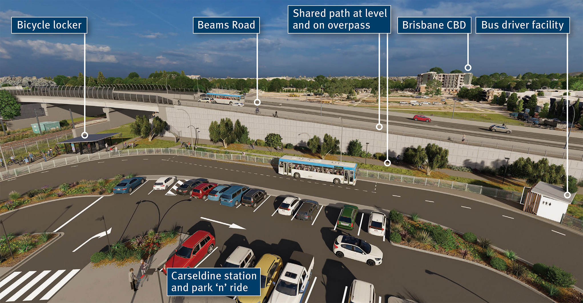
View of the new overpass from inside Carseldine park 'n' ride facility looking toward Brisbane CBD. It shows the new bicycle locker to the left, the end of trip bus driver facility to the right, the dedicated bus lane on the inside of the park 'n' ride facility and also the shared path at level and on the structure itself.
Upgraded Carseldine park 'n' ride including new bicycle facilities

View from the existing train lines, looking towards the Clock Corner Shops and the new overpass. Image shows new dedicated bus lane with the park 'n' ride facility and the new bicycle lockers and racks.
Upgraded Carseldine park 'n' ride, showing dedicated bus lane and new access to Balcara Avenue

View of the upgraded Carseldine station park 'n' ride facility, the new dedicated bus lane around the outside of the carpark, the upgraded kiss 'n' ride area and the new access road through to Balcara Avenue. Image is looking from Balcara Park towards the new overpass on Beams Road.
New overpass showing on road cycle lanes and shared paths

View across the new Beams Road overpass towards the Clock Corner Shops and the Carseldine station and park 'n' ride facility. There are shared paths at ground level next to the overpass with an underpass linking north and south adjacent to the train line. There are shared paths, separated with a concrete barrier, on each side of the overpass as well as on-road cycling lanes.
Aerial view looking towards Bracken Ridge

Aerial view looking towards Bracken Ridge with the new Beams Road overpass in the foreground. It shows Balcara and Beams intersection on the left and Carselgrove and Beams intersection to the right of the image.
Flythrough – February 2023 (subject to final design changes)
Beams Road (Carseldine and Fitzgibbon), rail level crossing project map
