


Boundary Road (Coopers Plains), upgrade rail level crossing, funding allocation
The Queensland Government is planning a new rail overpass to reduce congestion and address safety concerns at Boundary Road (Coopers Plains) rail level crossing.
The new crossing will include an overpass over the existing rail line at Boundary Road and an elevated 3-way intersection connecting Boundary Road and Orange Grove Road.
Feedback from mid-2022 community consultation and results from site investigation works completed in late 2023 informed further refinements to the project design.
Benefits
- Improves safety
- Increases capacity
- Improves network efficiency
- Increases traffic flow
- Reduces peak hour congestion
- Reduces interchange queuing
- Reduces travel time
- Contributes to economy
Key features
- An overpass over the existing rail line at Boundary Road and elevated three-way intersection connecting Boundary Road and Orange Grove Road to improve safety and reduce congestion.
- New active transport facilities, including on and off-road bike riding connections and dedicated pedestrian paths to improve connectivity for pedestrians and people riding their bikes.
- Improved local access, including a new traffic connection between Henley Street and Beenleigh Road, Babbage Street and Breton Street and new local access off Beenleigh Road to enhance local connectivity.
Funding
This project is a planned investment. The Australian and Queensland governments, and Brisbane City Council have allocated funding towards planning for a rail overpass at Boundary Road (Coopers Plains).
Investment ID: 1488479
Current status
Project design is complete.
The Queensland Government remains committed to this project for future delivery; however, some project dates have been adjusted to support a pipeline that is prioritised, sequential, and ultimately sustainable to ensure Queensland is well placed to support future growth needs.
Planning for this project is continuing. The timing of the project remains subject to relevant approval processes.
Properties acquired as part of project planning were demolished in mid-2026. The vacant lots will be enhanced with fencing and some landscaping.
A construction date for the project has not been set.
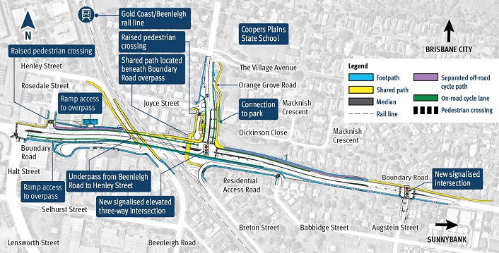
- the Gold Coast / Beenleigh rail line at Coopers Plains
- 2 raised pedestrian crossings
- a shared path located beneath the Boundary Road overpass
- ramp access to the overpass at 2 locations
- an underpass from Beenleigh Road to Henley Street
- 2 new signalised intersections on Boundary Road
- a new road connection to Dickinson Close Park.