Gympie – Brooloo Road, design active transport crossings
Detailed design is underway for active transport bridges and pathways to connect Southside to Gympie's CBD and surrounds.
Design activities for the project are funded under the Active Transport Investment Program, which delivers infrastructure that supports a safe, direct and connected cycling network.
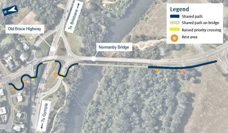
The design includes stand-alone bridges and connecting pathways for use by bicycle riders and pedestrians, across the Mary River and Bruce Highway, just north-west of the existing Normanby Bridge.
Benefits
- Improves safety
- Accessibility
- Better active transport
Key features
- Improve safety and amenity for pedestrians and bicycle riders.
- Improve connectivity for pedestrians and bicycle riders from Southside into the Gympie CBD and surrounds.
- Complete a missing link on the Gympie Principal Cycle Network.
Funding
Investment ID 1983825
- Total investment
- $1.3 million
- Queensland Government
- $1.3 million
Current status
We are currently undertaking detailed design.
Community consultation was undertaken from October to December 2021 to help inform the design for the new active transport facilities.
Overall, there was support for the project, feedback highlighted concerns regarding the location and height of the active transport crossings.
Alternative locations were considered, but they didn’t align with the Principal Cycle network. Additionally, the possibility of constructing higher crossings was explored, but this may have resulted in significant flooding impacts on upstream properties, making it unfeasible.
We are collaborating with Gympie Regional Council to ensure connectivity with the local pathway network.
Detailed design is expected to be completed in late 2023 and while there is no funding allocated to construct the transport crossings, a completed design will position the project to progress quickly should funding become available.
Gympie-Brooloo Road, design active transport crossing location map
1. Proposed active transport crossing location


