
Coomera Connector (Stage 1) Business case summary
Back to Coomera Connector Stage 1
On this page:
- Project summary
- Introduction
- Investing in Queensland's economy
- Coomera Connector (Stage 1) objectives
- Funding
- Protecting the M1
- The M1 is a key freight route
- Challenges facing the northern Gold Coast and Logan
- Consequences of not addressing these challenges
- The Coomera Connector addresses these challenges
- Coomera Connector (Stage 1) project
- Options analysis
- Environmental assessment
- Community and stakeholder outcomes
- Delivering the Coomera Connector (Stage 1)
- Stage 1 packages
- Planning for the future
Project summary
The Australian Government and Queensland Government have committed to building the Coomera Connector (Stage 1).
The Coomera Connector (Stage 1) is a region-shaping project that will provide an alternative transport route to the Pacific Motorway (M1) for local trips between Coomera and Nerang. This will reduce traffic on the M1, relieve congestion, and improve the resilience of the transport network for all motorists.
Ultimately, the Coomera Connector will extend from Loganholme to Nerang to connect the fast growing residential and employment centres in Logan and the Gold Coast.
The Coomera Connector is the preferred option to relieve current and future congestion on the M1 and will improve the productivity of the Gold Coast by relieving congestion and increasing the number of people that can access their jobs within 30min.
The Coomera Connector (Stage 1) business case has been prepared by the Department of Transport and Main Roads.
The Coomera Connector is a key component of the Queensland Government’s plan to cater for high levels of population and jobs growth within South East Queensland and enable the region to grow, while maintaining its enviable sub-tropical lifestyle.
- An additional 600,000 people will live in Logan and the Gold Coast by 2041.
- Coomera, Pimpama and Ormeau are some of the fastest growing suburbs in Queensland.
- The busiest section of the M1 is between Exits 60 and 62, with more than 210,000 vehicles passing through on the busiest days.
- 75% of vehicles that enter the M1 at Pimpama (Exit 49) and Coomera (Exit 54) exit the motorway at, or before Smith Street (Exit 66).
- Stage 1 of the Coomera Connector will provide 2 additional river crossings, at the Coomera and Nerang Rivers.
Introduction
The corridor between the northern Gold Coast and neighbouring Logan is experiencing significant growth and is identified in ShapingSEQ as a key area where people want to live, work and play.
Without the Coomera Connector, increasing demand for travel on the M1 will jeopardise its performance as part of the National Land Transport Network, servicing South East Queensland and the east coast of Australia.
Planning for future growth, the Coomera Connector will be a motorway-standard road from Loganholme to Nerang and will deliver an alternative transport corridor to complement the function and role of the M1.
The Coomera Connector will ultimately provide motorists with additional crossings of the Logan, Albert, Coomera and Nerang Rivers. It will include divided carriageways, grade-separated interchanges, and an arterial road connection to Beenleigh—Redland Bay Road.
The Coomera Connector is the most effective and economically efficient solution for addressing the road transport demands of increasing population and congestion in the region. The project will improve accessibility to key activity centres to stimulate economic growth, employment and social outcomes.
The Coomera Connector project will directly improve the resilience and reliability of the transport network in the study area by providing a viable alternative route in an alternative corridor and reducing congestion and forecast growth in volumes on the M1.
Stage 1 of the Coomera Connector is the first step in delivering a new motorway-standard road from Loganholme to Nerang that will connect the fast-growing residential and employment centres of the northern Gold Coast and Logan, and allow for efficient movement of freight and people within South East Queensland and beyond.
Investing in Queensland's economy
Detailed economic analysis completed for the business case shows that the Coomera Connector (Stage 1) project is an economically efficient project with a Benefit Cost Ratio of 1.9, meaning that for every $1 spent constructing the Coomera Connector, it will return $1.90 to the Queensland economy.
The economic assessment framework considered a wide range of benefits and costs of options that would, to varying degrees, address the critical constraints along the M1 between Loganholme and Nerang. The framework adopted aligns with the Queensland and national economic assessment guidelines.
PricewaterhouseCoopers were engaged as independent consultants to undertake a comparison of the costs and benefits of the Coomera Connector (Stage 1) to a base case, with the base case including a range of existing and planned infrastructure for the northern Gold Coast and Logan regions.
The economic assessment demonstrated the Coomera Connector between Coomera and Nerang had the highest Benefit Cost Ration with the benefits of the project exceeding the costs by $1.5 billion in net present value terms.
When wider economic benefits are included this adds more than $900 million of benefits (present value) representing the increased productivity of the region through greater density of economic activity, reduced transport costs for businesses and workers, and increased workforce participation.
Motorists will be the primary beneficiaries from the project with travel time savings and reduced operating costs for all road users (passenger and freight) comprising most of the economic benefits.
Coomera Connector (Stage 1) objectives
The Coomera Connector (Stage 1) is a city-shaping project that will connect the regional growth centres of Coomera and Pimpama, with the economic centres of Southport, Broadbeach and the southern Gold Coast.
This new connection will be a critical link in the Gold Coast transport network and a viable alternative for intra-regional travel, making the network more resilient and providing long term congestion relief for the M1.
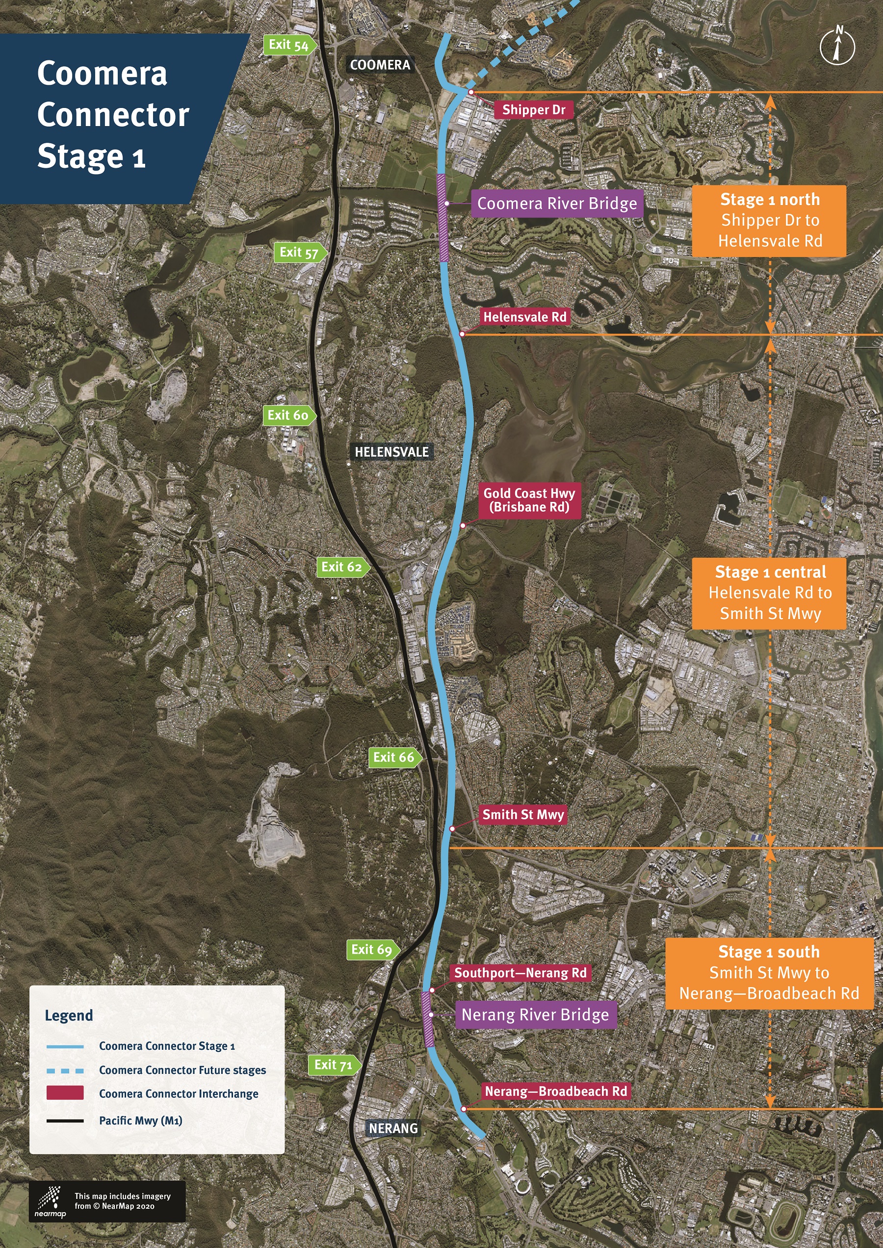
Stage 1 of the Coomera Connector will deliver a new high-speed road, approximately 16km long, connecting Shipper Drive at Coomera to Nerang—Broadbeach Road at Nerang. It will include grade-separated interchanges at Helensvale Road, Gold Coast Highway, Smith Street Motorway and Southport—Nerang Road and at-grade connections at Shipper Drive and Nerang—Broadbeach Road.
The project will give motorists an effective alternative to the M1 and will help cater for increased traffic around the northern Gold Coast, where the population is expected to grow from 396,000 residents in 2021 to 620,000 in 2041. The Coomera Connector will make the Gold Coast more productive by allowing more people to spend less time travelling to their work.
Strategic transport modelling has confirmed the benefits of the Coomera Connector (Stage 1) by demonstrating significant congestion relief and travel time savings for the M1 and supporting road network.
The Coomera Connector (Stage 1) will provide an alternative high-speed road to the east of the M1, and results in lower trip volumes on the M1 at locations within the extent of the Coomera Connector.
When it opens in 2026 the Coomera Connector will carry up to 60,000 trips per day between the Gold Coast Highway and Smith Street Motorway, reducing congestion and improving the performance of the M1 and the supporting road network.
Building future stages of the Coomera Connector (ultimately to Loganholme) will continue to alleviate congestion on the M1 and improve the resilience and reliability of the transport network.
- North-south transport corridor from Shipper Drive in Coomera to Nerang-Broadbeach Road
- New bridges - Coomera and Nerang Rivers
- 4 grade-separated interchanges
- Shared pedestrian/bike path
- Wildlife crossings
- More than 77,000m2 of noise barriers
The Coomera Connector will improve productivity of the Gold Coast and Logan. By 2041, the Coomera Connector will increase the number of residents that can access their jobs within 30min by 13% (from 186,700 to 210,700).
Funding
The Australian Government and Queensland Government have committed a total of $2.16 billion (on a 50:50 basis) to plan and construct Stage 1 of the Coomera Connector between Coomera and Nerang.
The business case confirms that the priority stage of the Coomera Connector is the section from Coomera to Nerang. The business case presents the detailed analysis that justifies investment in this first stage and establishes a plan to deliver the project.
Protecting the M1
The M1 from the New South Wales border to Brisbane is the highest trafficked road in Queensland and is an enabling link for long-distance traffic (freight, tourism, commercial and commuter) between economic hubs on the east coast of Queensland and New South Wales.
The capacity of the road network between Brisbane and the Gold Coast was identified as a problem in the 2019 Infrastructure Australia Audit. Infrastructure Australia has noted that by 2031, even with committed investment including motorway widening, the M1, in terms of total delay hours, will be South East Queensland’s most congested road corridor during the AM peak, with the section from Helensvale to Beenleigh ranked 2nd worst.
Overall, the M1 between Helensvale and Beenleigh will, by 2031, be ranked 2nd worst in Queensland during both the AM and PM peaks and the 5th most congested road in the AM peak in Australia.
The section of the M1 between Beenleigh and Nerang is the highest capacity road in Queensland with 8 traffic lanes, high quality pavement, and high speed interchanges. Despite this however, the capacity of this section is regularly exceeded in the peak periods, particularly from Coomera to Nerang and during incidents.
Given these capacity issues, we have identified a strategic and economic need to improve the M1 from Loganholme to Nerang and undertook a strategic assessment, preliminary evaluation, and business case to determine the most effective way to provide additional capacity and reduce congestion on the M1.
The M1 is the only north-south route connecting Brisbane to the Gold Coast and all traffic must use the M1, resulting in the M1 also performing multiple functions catering for short (intra-regional) and long distance (interstate) trips.
The M1 is susceptible to incidents and peak congestion, which impact national freight efficiency, intra-regional commuters, tourists and the local communities adjacent to the M1. In 2019 there were 3853 incidents (10.5 per day) that caused significant disruption to all M1 users between Brisbane and the New South Wales border.
The northern Gold Coast is at a critical juncture. Without new transport infrastructure, the existing network will become heavily congested beyond the traditional peak period and travel times will increase significantly for local and interstate travel on the M1. Without investment, a morning peak trip from Coomera Town Centre to Southport will increase by 150%, from 23mins in 2016 to 58mins in 2041, and a trip from Brisbane to Southport will increase by 77% over the same time period.
The M1 is a key freight route
Congestion on the M1 will also impact on freight movement in the region, with peak travel times between the New South Wales border and the Port of Brisbane forecast to increase by 75mins from 90 to 165mins between 2016 and 2041.
This congestion will also impact on container-based freight and bulk freight as more than 1.2 million containers are transported largely via the M1 to the rest of Queensland and northern New South Wales each year.
The freight task will continue to grow, with the current freight volumes increasing by more than 6% each year and an increase in freight nationally of 86% expected by 2031.
Australia’s population is increasing rapidly, but the freight task is growing even faster with increasing exports and consumer demand for more goods delivered quickly to their door.
The M1 is a key link in the National Land Transport Network and is the second busiest heavy vehicle route between capital cities in Australia. There is an ongoing shift by interstate road freight operators to take the coastal route (via the Pacific Highway/Pacific Motorway), due to logistical efficiencies in delivering to destinations, including commercial and industrial precincts, along the Pacific Coast in New South Wales.
These factors will continue to increase demand on the M1.
Challenges facing the northern Gold Coast and Logan
The transport network in the northern Gold Coast is being placed under increasing pressure due to population growth, a lack of alternative routes, and increasing freight movements.
Population is forecast to grow by approximately 600,000 residents between 2016 and 2041 in Logan and the Gold Coast, representing 32% of the overall population growth for South East Queensland.
Within the study area surrounding the Coomera Connector (Stage 1) the population will increase by 280,000 people between 2016 and 2041, compared to an increase of only 120,000 full time equivalent jobs in the same area.
This misalignment between population and employment growth will result in an increase in the number of trips using the M1 to access employment to double between 2016 and 2041.
This will continue to compromise the ability of the M1 to serve as a critical link for long-distance travel between major economic hubs along the east coast of Australia, and as a link for the population and employment centres of Brisbane, Logan and the Gold Coast.
Major transport hubs including the Brisbane and Gold Coast airports and the Port of Brisbane will also be impacted by congestion.
Consequences of not addressing these challenges
Transport modelling forecasts demonstrate an immediate need for action and intervention, as the M1 is currently experiencing high traffic volumes which regularly exceed the daily capacity between Coomera and Nerang.
Congestion during peak hours at the Coomera River and Nerang River crossings will reach excessive levels significantly above the daily capacity by 2026.
By 2041, the Coomera River crossing is forecast to be approximately 50% over capacity during peak periods and the Nerang River will be approximately 20% over capacity.
Increasing congestion will impact travel speeds and travel times along the M1. The average speed between Coomera and Nerang (Exits 54 to 73) is forecast to reduce from 92km/h in the northbound AM peak and 81km/h in the southbound PM peak in 2016 to 46km/h and 37km/h in 2041, respectively. Substantial increases in travel time are expected, with a trip (car or freight) between Nielsens Road, Nerang and Coomera Town Centre increasing 166% in 2041.
Without intervention, the viability of the M1 as an inter-regional and freight route is threatened.
The consequences of not acting:
- Jobs accessible within 30mins forecast to decrease by 28% to 2041.
- Drop in AM peak speed from Coomera to Nerang (2016 to 2041).
- Drop in PM peak speed from Coomera to Nerang (2016 to 2041).
- Travel time between Nielsens Road, Nerang and Coomera Town Centre increase from 15mins to 40mins in 2041.
- Freight travel from the NSW border to Port of Brisbane increasing by 75mins from 90mins (2016) to 165mins (2041).
- Coomera River crossing 50% (86,6000 vehicles) above capacity by 2041.
- Nerang River crossing 20% (30,400 vehicles) above capacity by 2041.
- Annual cost of congestion increasing from $409 million to $3,053 million in 2041.
The Coomera Connector addresses these challenges
The Coomera Connector (Stage 1) will provide an alternative route for local commuter trips and intra-regional travel between Coomera and Nerang, reducing the reliance on the M1 as the only viable north-south route.
Addressing these challenges will:
- Increase the capacity of the transport network for the critical north-south trips.
- Provide additional river crossings of the Coomera and Nerang Rivers.
- Provide an alternative route for shorter trips to preserve the function of the M1 for long-distance freight and inter-regional travel as part of the National Land Transport Network.
- Provide increased accessibility and connectivity to and from Coomera and the growth regions in the northern Gold Coast.
- Improve reliability in the transport network for non-recurring congestion (i.e. incidents) on the M1 that can result in major congestion.
- Encourage active transport along the corridor.
Coomera Connector (Stage 1) Project
The Coomera Connector (Stage 1) project will provide a new 16.25km north south high-speed road connecting Shipper Drive in Coomera to Nerang–Broadbeach Road in Nerang
. The Coomera Connector (Stage 1) includes:
- New bridge crossings of the Coomera and Nerang Rivers
- Grade-separated interchanges at Helensvale Road, Gold Coast Highway (Brisbane Road), Smith Street Motorway and Southport—Nerang Road
- Major waterway and wetland bridge structures over Saltwater Creek, Coombabah Creek, Coombabah Lakes Wetland
- Overpass structures for local roads at the crossings with Ridgevale Drive, Town Centre Drive and Sage Street (future road)
- A shared pedestrian/bike path with connections into existing and future local active transport networks
- Protection or relocation of existing service utilities
- Intelligent transport systems including variable message signs (VMS) and closed circuit television (CCTV) to provide connectivity with the M1 Smart Motorway concepts
- Permanent water quality management measures including swales and basins
- Wildlife crossings supporting identified fauna corridors.
Number of traffic lanes
Transport modelling undertaken for the business case has determined that the required capacity of the Coomera Connector (Stage 1) is 4 lanes (2 in each direction) to meet demand for 10-15 years from opening. This will provide a viable alternative transport link to the M1 supporting the future growth of the northern Gold Coast.
Major bridge structures at key locations will include provision for future 6-lane capacity.
Extending the Coomera Connector to the north may bring forward the need to widen sections of Stage 1 as more communities gain access to the Coomera Connector and traffic volumes on Stage 1 increase.
Geotechnical conditions
The Coomera Connector (Stage 1) project requires an extensive range of earthworks and ground treatments including embankment construction, reinforced soil wall construction, and piling and excavation for cut slopes adjacent to light and heavy rail infrastructure. A range of impact assessments were undertaken in the design process and will continue to be evaluated in the detailed design phase, supported by site investigations.
Soft soils
Soft soils occur in multiple locations along the Stage 1 alignment and pose a risk of excessive settlement if not treated during the construction phase. Treatments include removing and replacing soft materials, earth preloading and compacting, water removal, and ground improvement with rigid inclusions (piling).
Soft soils often occur in low-lying areas and near to waterways that are prone to flooding and inundation. Where this occurs bridge structures may be extended instead of carrying out extensive ground treatment works.
Bridges and structures
The Coomera Connector (Stage 1) includes significant bridge and retaining wall structures including major crossings of the Coomera and Nerang Rivers, and crossings of Saltwater Creek, the Coombabah Wetlands, Careel Reserve, and Coombabah Creek.
In addition to river and creek crossings, the project includes significant bridges at interchanges and road crossings including the Smith Street Motorway and Gold Coast Highway.
As the project will be built in a constrained transport corridor alongside existing rail assets, the design includes retaining walls to limit the impact of earthworks on adjacent properties and structures.
Design treatments will be applied to structures, where applicable, to enhance appearance and integrate with the local surrounds including architectural treatments to abutments, piers and pedestrian balustrades. These will seek to minimise visual impact, maximise views and integrate treatments which respond to and celebrate the natural and social environment of the Gold Coast.
Wildlife protection
South East Queensland provides habitat for a range of native fauna species and the urbanisation of the region has significantly encroached into much of this fauna habitat. Several key areas and fauna corridors remain however, and maintaining or improving fauna connectivity is an important consideration for the Coomera Connector project. Bridges have been designed to facilitate fauna movement and fauna furniture including log rails, refuge poles and glider poles are proposed.
Fauna fences will be provided to direct fauna to purpose built connection points to prevent their access to the roadway. Where possible, fences and barriers will be consolidated to reduce visual clutter along the alignment.
Active transport shred user path
The Coomera Connector (Stage 1) will include a dedicated active transport path (shared pedestrian and bike-riding path).
The shared path will significantly improve active transport connectivity for the Gold Coast’s northern suburbs by providing a high quality direct north-south route between Shipper Drive and Nerang—Broadbeach Road. It will deliver significant improvement in active transport accessibility and connectivity between destinations in Coomera, Hope Island and Helensvale with a new active transport connection across the Coomera and Nerang rivers.
Hope Island Road connection
The area near the Coomera Connector at Hope Island Road is highly constrained with the rail corridor and planned Hope Island train station and residential properties.
Investigations have concluded that it is not feasible to provide a connection to Hope Island Road due to the significant number of residential properties and businesses that would need to be acquired and the high costs associated with extensive bridging for on and off ramps.
Access to the Coomera Connector for nearby suburbs including Hope Island, Sanctuary Cove and Paradise Point will be provided via the Helensvale Road interchange.
Options analysis
The Coomera Connector has been selected as the preferred project through a comprehensive options analysis process.
| Stage | Analysis and options considered | Outcome |
|---|---|---|
| Strategic Corridor Options Assessment |
This stage assessed options at the corridor level from Loganholme to Nerang. This assessment identified the need for increased north-south transport capacity between Loganholme and Nerang, and examined more than 100 options within the available transport corridors including the M1, Coomera Connector, and Public Transport upgrades. The options were assessed using multi-criteria analysis and shortlisted to the top 5 options for the preliminary evaluation. |
Corridor level solution is required. Road solution is required to meet capacity. M1 upgrades and Coomera Connector corridor options to be considered in preliminary evaluation. |
| Preliminary Evaluation Options Assessment |
This stage assessed options at the corridor level from Loganholme to Nerang. The preliminary evaluation used a quantitative multi-criteria assessment to identify the top performing options in the preliminary evaluation phase. The analysis used strategic transport modelling, concept designs, property impacts, and cost estimates to inform the assessment and select the top four options for economic assessment. |
Top 4 options progressed to economic assessment including the Coomera Connector and 3 levels of investment in the M1 corridor. |
| Preliminary Evaluation Economic Assessment |
This stage assessed options at the corridor level from Loganholme to Nerang. The analysis at this stage used a cost-benefit analysis framework to develop a benefit cost ratio for each of the options and identified the preferred options for analysis in the business case. Options included the Coomera Connector, widening the M1 from the existing 4 lanes to 5 lanes and 6 lanes in each direction, and rebuilding the M1 to include 4 express lanes and 3 high speed arterial lanes in each direction. |
The Coomera Connector was identified as the preferred option. The best performing M1 option (widening the M1 to 6 lanes in each direction) was taken forward into the business case as a comparable project. |
| Business Case |
The business case assessed options at the project level from Coomera to Nerang. The business case compared the priority stage of the Coomera Connector (Coomera to Nerang) with upgrades to the M1 (to 6 lanes in each direction). |
The Coomera Connector (Stage 1) was identified as the preferred project and recommended for funding and delivery. |
Environmental assessment
Protecting the environment is an important part of planning new road projects.
We conducted almost 3 years of terrestrial, ecological and aquatic surveys to ensure that the level of impact the project will have on the environment is understood, and that appropriate mitigation strategies are developed.
Environmental approvals for the Coomera Connector (Stage 1) are being progressed with the federal Department of Climate Change, Energy, the Environment and Water under the Environment Protection and Biodiversity Conservation Act 1999.
Environment Protection and Biodiversity Conservation Act 1999 referral
In March 2020, the Coomera Connector (Stage 1) was referred to the former Department of Agriculture, Water and the Environment to determine the level of environmental impact and the assessment process that would apply to the project.
On 14 August 2020, it was determined the project would be a controlled action under the Act, and the assessment approach would be by Public Environment Report. A Public Environment Report represents a comprehensive investigation of the potential impacts of the project and the findings are made available to the public for comment.
Based on the information available in the referral, the proposed action is likely to have a significant impact on the following matters of national environmental significance, including but not limited to:
- Koala – the proposed action involves the clearing of habitat critical to the survival of the species. This includes a range of habitat categories including bushland habitat, rehabilitation and other and each range from low to high value, however only a portion of the mapped koala habitat within the referral area is bushland habitat.
- Grey-headed Flying-fox – the proposed action involves the clearing of habitat that is critical to the survival of the species.
- Coastal Swamp Oak forest of New South Wales and South East Queensland ecological community – the proposed action involves the clearing of habitat that is important to the survival of the threatened ecological community.
- Moreton Bay Ramsar Wetland – the proposed action will impact on the Moreton Bay Ramsar Wetland and may have additional indirect impacts to the Ramsar site due to the clearing of mapped wetlands within the referral area which contribute to the Moreton Bay Ramsar Wetland catchment.
- Migratory birds – The proposed action also has the potential to impact on several migratory bird species.
The extent of these potential impacts and mitigation strategies will be documented in the Public Environment Report that will be available for public review and approval by the Australian Government.
Public Environment Report
On 14 October 2020, former Department of Agriculture, Water and the Environment issued the final guidelines for the Public Environment Report. The Public Environment Report outlining our approach to managing environmental issues (including strategies to maintain wildlife movement corridors) will be made available for comment from late 2022. Final Environment Protection and Biodiversity Conservation Act 1999 approvals and construction conditions will be in place in advance of the mainline construction starting for the first major package of works between Shipper Drive and Helensvale Road.
Koala management plan
As part of the extensive planning for the Coomera Connector project, we are working with subject matter experts to develop a koala management plan and other environmental management plans to manage impacts on wildlife habitat in and around the project corridor.
This includes extensive wildlife surveys to confirm existing wildlife movement corridors and the inclusion of wildlife movement structures and exclusion fencing in the design. To ensure that impacts to habitat are addressed, the plan will also include the acquisition and rehabilitation of additional offset land to support local wildlife populations and to replace areas of habitat lost for the Coomera Connector.
Community and stakeholder outcomes
A transport corridor delivered in an urban environment will inevitably impact residents, businesses and transport users. However, the project is located within a predominantly greenfield corridor which helps minimise direct impacts to property owners.
Social benefits and impacts
The Coomera Connector will provide significant value and positive long-term benefits to local communities and stakeholders, including:
- improved travel times and ease of movement on the M1 by increasing the capacity of the transport network
- improved reliability of travel times for users by providing an alternative route to the M1
- improved active transport access for communities with a new dedicated shared walking/bike-riding path
- improved connectivity between economic and population centres for residents by providing alternative routes
- increased resilience of the transport network for all users
- improved safety for users in the study area by reducing traffic congestion and thereby reducing potential for accidents
- improved freight efficiency and economic productivity for South East Queensland.
To improve the social value generated by the Coomera Connector, opportunities to enhance the positive social impacts and maximise the benefits of the new corridor have been incorporated.
The project will include features to minimise these impacts wherever possible, such as:
- Installing noise barriers to reduce impacts to nearby residents and businesses, in accordance with requirements outlined in the Transport Noise Management Code of Practice.
- Ensuring the road is constructed using a quieter pavement surface than concrete.
- Using LED streetlights that are able to be monitored and adjusted for light spill.
- Installing air quality stations and long-term monitoring.
- Authorising contractors’ construction management plans and auditing activities to ensure compliance regarding construction vibration, dust, noise and lighting.
The Queensland Government owns more than 85% of the corridor between Coomera and Nerang and has progressively been obtaining land within the corridor over the past 2 decades. There is a requirement to acquire 24 properties with a large proportion of these owned by the City of Gold Coast.
Overall, the value and scale of the positive benefits the Coomera Connector is expected to generate for local communities, greatly outweighs the potential negative impacts.
Community and stakeholder engagement
We have undertaken community and stakeholder consultation across the Coomera Connector corridor between Loganholme and Nerang and additional consultation has occurred during business case development between Coomera and Nerang.
This has included:
- Corridor protection phase: consulting with affected landowners prior to the gazettal of the corridor to provide additional information and answer questions from affected landowners
- Preliminary evaluation phase: a comprehensive month-long program was undertaken from 8 November to 8 December 2019 across the entire 45km project corridor. The focus of the community consultation was to listen to community input to help ensure the project takes the local context into account
- Business case phase: building on the consultation undertaken in previous phases, we engaged with the community through:
- consulting with residents who live close to the Coomera Connector corridor and other key stakeholders to enable community input to influence the identified project negotiables
- responding to broader community enquiries about progress of the project
- informing the broader community about the project.
To achieve the business case consultation goals we used the following communication and engagement strategies:
- Project newsletters were distributed to those located near to the Stage 1 corridor to keep the broader community regularly informed on progress of the project and to invite community members to participate in community consultation activities. More than 170,000 newsletters were distributed in September 2020 and almost 144,000 in March 2021.
- Online engagement was used to continue gaining community input into the identified project negotiables including urban design-related aspects such as design treatments for noise barriers and retaining walls, aspects of the shared path for walking and bike-riding, and landscaping and planting in the corridor.
- A Community Reference Group was established for Stage 1 of the Coomera Connector to ensure residents, businesses and key environmental stakeholders had the opportunity to provide input into the key project negotiables.
The Community Reference Group included residents from 10 local communities located along the corridor, businesses and community environmental groups. Read the summary of questions, issues and opportunities raised and discussed in the Community Reference Group.
Delivering the Coomera Connector (Stage 1)
Delivery of the Coomera Connector (Stage 1) is underway. Site investigations commenced in mid-2021 and major construction work is scheduled to start from late 2022 following environmental approvals. Stage 1 will be delivered in 3 packages.
Stage 1 packages
The packaging and delivery model for the Coomera Connector (Stage 1) was chosen to maximise construction market interest, package together similar project scope items, and provide greater certainty for construction commencement and completion dates.
The delivery strategy aligns these elements, providing the greatest opportunity to increase contractor participation and private sector innovation, while reducing interface risk between contract packages.
Stage 1 North package
The Stage 1 North package includes a new bridge crossing over the Coomera River and interchanges at Shipper Drive in the north and Helensvale Road in the south.
The Stage 1 North package will be delivered first using a competitive Early Contractor Involvement delivery model. Using this model, a private sector consortium has been engaged to design and construct the project, giving them the greatest flexibility and control of the design solution and construction methodology. This will allow the private sector to be innovative and to bring national and international expertise to optimise the design, construction methodology, and the timing of construction.
Procurement of the Stage 1 North package commenced in December 2020 and the shortlisted bidders were selected in March 2021.
An early works agreement was awarded in November 2021 to enable the design of Stage 1 North to be finalised. Construction will commence following environmental approvals which is expected to be from late 2022.
We have a high degree of success using the collaborative Early Contractor Involvement contract to drive performance and quality outcomes in recent projects.
Stage 1 Central package
The Stage 1 Central package contains the complex and key interchanges with the Gold Coast Highway and Smith Street Motorway, the soft soil areas near the Gold Coast Highway, and the interfaces with the Gold Coast Light Rail system and Gold Coast heavy rail line.
By creating a single package for these elements, it will enable a greater level of innovation in both the design and construction phases and create a single integrated solution for these complex elements. The Stage 1 Central package will also be delivered using a competitive Early Contractor Involvement model.
Requests for proposals were released to industry in early November 2021. A design and construct contract is expected to be awarded in late 2022.
Stage 1 South package
The Stage 1 South package includes the grade separated interchange at Southport—Nerang Road and a new bridge crossing of the Nerang River to connect to Nerang—Broadbeach Road.
A design contract is expected to be awarded in September 2022.
Managing construction impacts
The Coomera Connector (Stage 1) will be constructed in a predominantly greenfield corridor, however the corridor is constrained due to proximity to commercial and residential properties, heavy rail and light rail assets, rivers and waterways, and protected environmental areas.
The construction contractors will develop and implement detailed construction management plans to mitigate or reduce the impacts of dust, noise, light and vibration on neighbouring communities.
The project includes 2 highly complex road network interchanges, at the Gold Coast Highway and Smith Street Motorway, as well as a number of interchanges and local road connections. Detailed traffic management plans will be developed for each of these locations to minimise the impact of construction and to keep existing traffic moving.
Planning for the future
The Coomera Connector is a key link in the transport network of the future for South East Queensland.
Ultimately the Coomera Connector will be a 45km long motorway-standard road from Loganholme to Nerang that connects Brisbane and the Gold Coast to the regional growth centres of Coomera (population) and Yatala (jobs and economy).
When the Coomera Connector is complete it will be a viable alternative to the M1 and allow the M1 to perform at (or near to) current levels of performance beyond 2041. In 2041, there will be a balancing of traffic between the 2 corridors, with the M1 continuing to provide inter-regional and inter-state travel, with more local trips using the Coomera Connector.
In 2041, transport modelling forecasts show a demand exceeding 300,000 vehicles per day crossing the Coomera River with approximately 192,000 vehicles using the M1 and over 100,000 vehicles using the Coomera Connector. This balance between the M1 and the Coomera Connector will be consistent over its length with between 60% and 70% of trips on the M1 and 30% to 40% on the Coomera Connector.
With the Coomera Connector in place, peak travel speeds on the M1 will improve significantly with the greatest improvement being 158% at the Logan River (which carries the highest volume of all river crossings in the study area) from 24km/h to 62 km/h.
Connections between local residential and economic centres will also be improved, with an increase of 49,800 jobs (+29%) accessible within 30mins from where people live.
Stage 1 of the Coomera Connector is being delivered, and planning is underway for the future stages. The Queensland Government will continue to invest in the M1 as the primary interstate transport route, with interchange upgrades, and smart motorways technology to be delivered to optimise the performance of the M1 to 2041 and beyond.