
South Coast 2020–21 flood reconstruction works
Reconstruction works are underway across the South East Region, including the Gold Coast and Scenic Rim, to repair storm damaged roads.
Following severe weather events, including the South East Queensland Coastal Trough in December 2020 and the Southern Queensland Severe Weather event in March 2021, more than 20 roads were damaged across the hinterland region. The department is undergoing reconstruction works to repair the damages caused including:
- landslips
- fallen trees
- flood damage
- drainage issues
- souring to bridge structure.
Reconstruction works will include fixing unstable slopes above and below the road, replacing damaged road surfaces, repairing damaged road shoulders, and repairing damaged culverts and bridges.
Initial emergency works have been completed which involved clearing hazards and making roads safe for road users.
Benefits
- Restores damaged infrastructure
- Contributes to economy
- Contributes to regional growth
Funding
Assistance will be provided through the jointly funded Commonwealth-State Disaster Recovery Funding Arrangements (DRFA).
Current status
Significant repairs are required in the Gold Coast hinterland and Scenic Rim following heavy rainfall in December 2020 and subsequent flooding in the same region in March 2021.South East Queensland Coastal Trough: 12–15 December 2020
- Reconstruction works on Tamborine Mountain Road, known locally as the Goat Track, are complete and the road reopened on Monday 1 August 2022 at 12pm.
Southern Queensland Severe Weather: 20–31 March 2021
- Temporary repairs were completed in June 2021 along Currumbin Creek Road at Currumbin Waters to remove a fallen tree and undertake pavement repairs and bank stabilisation works.
- Pavement repairs and drainage works along Binna Burra Road were completed in June 2021.
Reconstruction works are underway on other damaged roads in the region. These include:
- Beechmont Road
- Currumbin Creek-Tomewin Road
- Gold Coast-Springbrook Road
- Nerang-Murwillumbah Road
- Cunningham Highway
- Beaudesert-Nerang Road
- Boonah-Rathdowney Road
- Lamington National Park Road
- Mount Lindesay Highway
- Running Creek Road
- Tamborine-Nerang Road.
South Coast 2020-2021 flood reconstruction impacted roads map - south
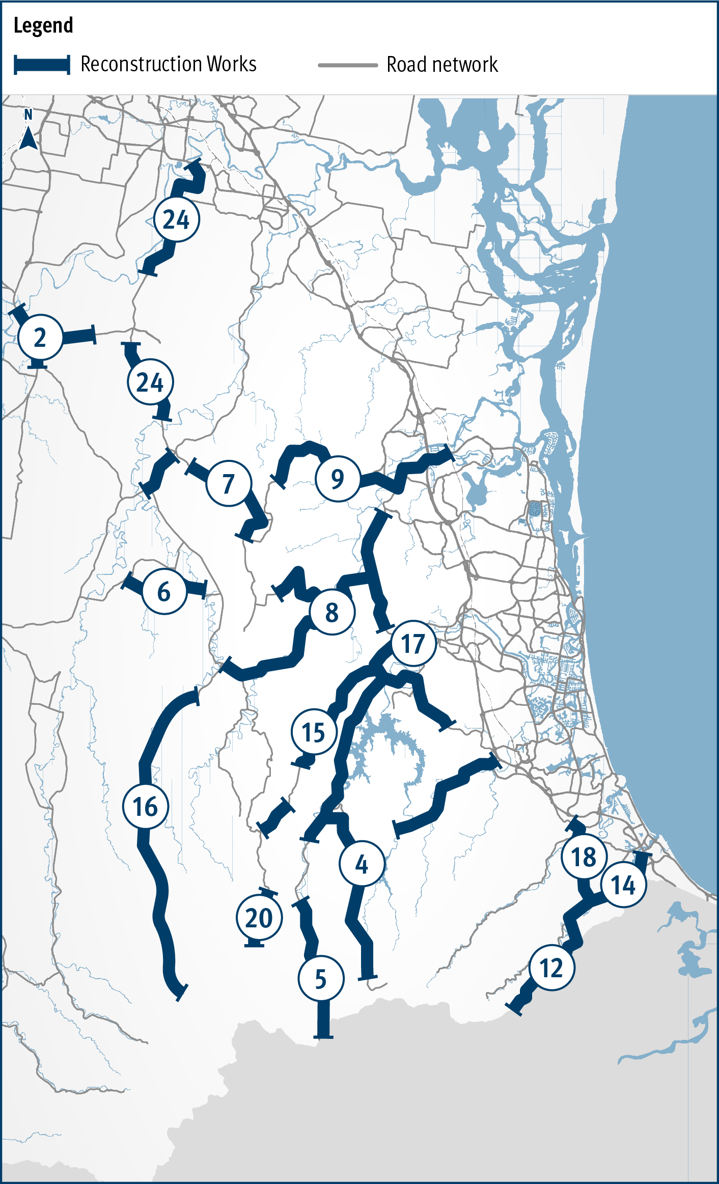
Impacted roads:
- 2 - Mount Lindesay Highway (Brisbane-Beaudesert)
- 4 - Gold Coast-Springbrook Road
- 5 - Nerang-Murwillumbah Road
- 6 - Beaudesert-Nerang Road
- 7 - Beaudesert-Beenleigh Road
- 8 - Tamborine Mountain Road (The Goat Track)
- 9 - Tamborine-Oxenford Road
- 12 - Currumbin Creek Road
- 14 - Currumbin Creek-Tomewin Road
- 15 - Beechmonth Road
- 16 - Lamington National Park Road
- 17 - Advancetown-Mudgeeraba Road
- 18 - Tallebudgera Connection Road
- 20 - Binna Burra Road
- 24 - Waterford-Tamborine Road
South Coast 2020-2021 flood reconstruction impacted roads map - west
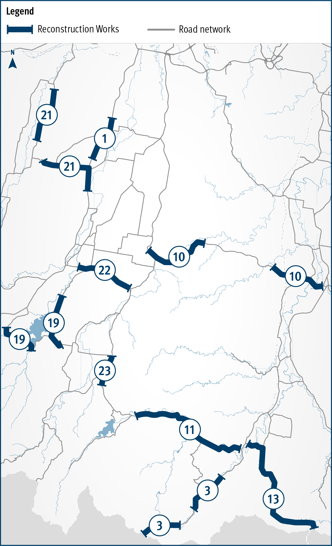
Impacted roads:
- 1 - Cunningham Highway (Ipswich-Warwick)
- 3 - Mount Lindesay Highway (Beaudesert - Border)
- 10 - Beaudesert-Boonah Road
- 11 - Boonah-Rathdowney Road
- 13 - Running Creek Road
- 19 - Lake Moogerah Road
- 21 - Rosewood-Warrill View Road
- 22 - Boonah-Fasslfern Road
- 23 - Mount Alford Road
