Bruce Highway Upgrade - Anzac Avenue to Caboolture-Bribie Island Road

Planning investigations have confirmed a preferred option for future upgrades that includes the following:

  • Bruce Highway from Anzac Avenue to Uhlmann Road:
    • adding an additional northbound and southbound lane in this section of the Bruce Highway, expanding capacity to accommodate increased traffic demands and future growth. These new lanes will be built in the existing median, increasing lanes from three to four in each direction.
  • Bruce Highway from Uhlmann Road to Caboolture-Bribie Island Road:
    • adding multi-lane, one-way collector-distributor roads on both sides of the existing Bruce Highway. Collector-distributor roads were identified as the most viable solution for this section of the highway, which has three interchanges and a service centre in close proximity.

Collector-distributor roads are built alongside and separate to a highway carriageway. Collector-distributor roads will enhance highway operation and safety by removing traffic undertaking local or short distance trips from the highway and by reducing the need for lane changes to merge or weave through highway traffic.

Benefits

  • Improves safety
  • Increases capacity
  • Improves network efficiency
  • Reduces peak hour congestion
  • Reduces interchange queuing
  • Improves flood immunity
  • Accessibility
  • Reduces travel time
  • Contributes to economy
  • Contributes to regional growth

Funding

The Australian and Queensland governments have committed $34 million to develop business cases for planned upgrades to the Bruce Highway between Anzac Avenue and Caboolture–Bribie Island Road:

Bruce Highway Upgrade—Anzac Avenue to Uhlmann Road Investment ID 2349359.

Bruce Highway Upgrade—Uhlmann Road to Buchanan Road Investment ID 2349159.

Bruce Highway Upgrade—Buchanan Road to Caboolture-Bribie Island Road Investment ID 2348820.

Due to the interdependent nature of the upgrades between Uhlmann Road and Caboolture-Bribie Island Road, planning is being completed as one study.

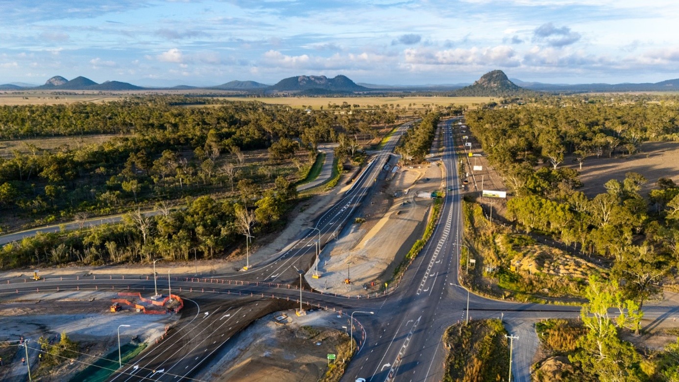
The Anzac Avenue to Uhlmann Road section will progress to detailed design phase early next year. Scoping and early works (detailed onsite investigations) commenced mid-2025. Construction staging, timeframes and duration will be confirmed as the design progresses.

Funding for the completion of detailed design and construction of the upgrades in the remaining sections has not been committed at this time.

Total investment
$34 million
Australian Government
$27.2 million
Queensland Government
$6.8 million

Current status

Planning for these upgrades started in early 2023 and is nearing completion.

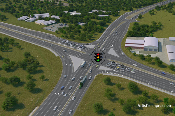
We have confirmed a preferred option for future upgrades to the Bruce Highway between Anzac Avenue and Caboolture-Bribie Island Road which includes a combination of additional lanes and collector-distributor roads.

Bruce Highway Upgrade - Anzac Avenue to Caboolture-Bribie Island Road project location map

Bruce Highway Upgrade Anzac Avenue to Caboolture Bribie Island Road project map ( https://sc-p-cm.tmr.saas.dataweavers.io/_/media/21e60286ecb8438d9e206a9a11f87def.ashx )

Uhlmann Road interchange

The upgrade will replace the existing two-lane overpass bridge with a new higher and longer overpass. Additional lanes will be provided at new signalised ramp intersections to improve traffic flow efficiency. The upgrade will include significantly improved active transport connections.

Buchanan Road interchange

The upgrade will replace the existing overpass bridge with a new higher and longer overpass. The existing roundabout ramp intersections will be upgraded to new signalised intersections to better control traffic flow and provide capacity where it is most needed. The upgrade will include significantly improved active transport connections.

Caboolture-Bribie Island Road interchange

The upgrade will replace the existing overpass with two new higher and longer overpass bridges, with additional traffic lanes plus new signalised ramp intersections to improve traffic flow efficiency. A new loop ramp connection will provide uninterrupted flow for traffic travelling from Caboolture towards Brisbane. The upgrade will include significantly improved active transport connections.

Bruce Highway Upgrade Anzac Avenue to Caboolture-Bribie Island Road

Video Transcript

The words Bruce Highway Upgrades – Anzac Avenue to Caboolture-Bribie Island Road appear on the screen, over a map of north Brisbane to Caboolture.

A green line identifies the project on the Bruce Highway from Anzac Avenue to Uhlmann Road and an orange line identifies the project area from Uhlmann Road to Caboolture-Bribie Island Road.

The project benefits are listed as improves safety, improves network efficiency, reduces interchange queuing, improves flood immunity, increases capacity and reduces congestion, improves active transport connectivity and access.

The section from Anzac Avenue to Caboolture-Bribie Island Road is highlighted and the key features noted. These are an upgrade to four lanes northbound and southbound, potential separate active transport corridor beside the highway, Anzac Avenue interchange to remain, Plantation Road overpass to remain and Boundary Road interchange to remain. The location of Westfields North Lakes is noted.

The flythrough moves north to highlight the following project features. Potential future active transport corridor along Old Gympie Road. Local realignment and upgrade of Frawley Avenue – Potassium Street and new Frawley Avenue overpass with active transport facility. Upgrade to four lanes northbound and southbound. Deception Bay Road interchange to remain. New active transport corridor and heavy vehicle interception site relocation location.

The flythrough moves further north showing the new Arthur Drewett Drive overpass, realignment of Arthur Drewett Drive with a new intersection with Progress Road and removal of Arthur Drewett Drive connection from the Progress Road roundabout.

The words “New and upgraded active transport facilities” appear and green lines highlight the location of these facilities at Arthur Drewett Drive overpass and adjacent to the Bruce Highway. New bridges over Burpengary Creek are highlighted.

The flythrough moves north to show the exit at the Uhlmann Road interchange for Morayfield and Burpengary East and the entry to the Bruce Highway from a signalised ramp from the Uhlmann Road interchange.

The words “Uhlmann Road interchange” appear and highlight the upgraded overpass, duplication of Uhlmann Road to the west and realignment of Uhlmann Road to the east. The location of the start of the collector-distributor road northbound is highlighted north of the Uhlmann Road interchange and new active transport facilities including an underpass under Uhlmann Road west of the interchange and paths either side of the overpass are highlighted.

North of the Uhlman Road interchange, the northbound exit to the Service Centre and Morayfield is shown and the southbound exit to Morayfield and Burpengary East is shown.

As the flythrough moves north the location of new active transport corridor is shown, along with the northbound collector-distributor road and the southbound collector-distributor road. The words “three lanes northbound” and “four lanes southbound” appear on the highway lanes along with the words “noise barrier” on the eastern side of the corridor.

Moving further north, the words “Access to Service Centre via collector-distributor road” appears on the northbound collector distributor roads and the words “Underground fauna crossing spanning the highway” appear to the south of the service centres.

The words Northbound Service Centre appear west of the highway and Southbound Service Centre appear east of the Bruce Highway. A label showing the location of a continuing active transport path appears just north of the Northbound Service Centre location.

Another fauna crossing label depicts a structure spanning the highway and an access to the Service Centre via collector-distributor road is shown on the southbound lanes.

The vision shows three lanes northbound and four lanes southbound on the main highway. A green directional sign points east showing the exit ramp to Morayfield and North Harbour. The ramp connects to Buchanan Road which is labelled and connects to the Buchanan Road interchange. A signalised intersections are shown and labelled on both sides of the interchange which shows an overpass spanning the highway.

A signalised intersection is labelled on the eastern side of the highway. It connects to a road labelled North Harbour Boulevard connection.

At the Buchanan Road interchange a new active transport underpass is shown under a run that runs east-west on the western side of the interchange and active transport facilities are also labelled on the eastern side of the interchange. As the words New active transport facilities appear green lines highlight the location of these facilities on the Buchanan Road overpass and alongside roads east and west of the highway and continuing parallel to the highway on the western side.

Continue to travel north along the highway a new label appears showing four lanes southbound. The visions zooms out to show an extended stretch of highway stretching northwards and in the distance another interchange is shown. In the foreground, braided highway ramps are shown as grade-separated roads.

Green directional signage appears on the screen showing exit points and pointing to locations where the exit ramps begin. The signs appearing from south to north are: Exit Caboolture-Bribie Island Road and D’Aguilar Highway. Three flashing lines appear on screen with each one showcasing available routes. A light blue and white flashing line is used to showcase the route that motorists would take to follow the Caboolture-Bribie Island Road and D’Aguilar Highway exit.

Further north another green directional sign points to D’Aguilar Highway and a green and white flashing line showcases the route that motorists would follow to reach that destination. It ends with motorists travelling north on a service road. Another green directional sign includes an arrow showing the direction to Caboolture and a dark blue and white flashing line indicates the route that motorists would travel to access Caboolture. Three flashing lines move at once to showcase the three route options that motorists have available, and the main highway has moving traffic, some cars and some trucks to simulate how the highway and collector-distributor roads will operate under traffic.

A green directional sign shows with a north-east pointing arrow and the words Bruce Highway showing the entry point for motorists to access the Bruce Highway. The blue and white and green and white flashing lines appear again. They are showcasing the two roues available for motorists to travel northbound and access the Bruce Highway. The flashing lines disappear, and the vision perspective slowly pans and switches to focus on the Buchanan Road interchange overpass that crosses the Bruce Highway.

The concept for the future Bruce Highway Upgrade from Buchanan Road showing the additional southbound lane, a new, separate active transport path, multi-lane, one-way collector-distributor roads on both sides of the existing Bruce Highway with signalised entry ramp on the eastern side. A signalised entry ramp is also shown on the western side of the Bruce Highway where northbound traffic joins the highway. A green directional sign with an arrow pointing north-east shows and the words Bruce Highway is shown at the merge point.

The concept continues showing the Bruce Highway and collector-distributor roads near Morayfield. Three new bridges across the Caboolture River are shown with blue shading and an existing northbound highway bridge is highlighted in a light blue colour to show it will be retained and modified for use as part of the northbound collector-distributor road.

The concept shows an exit ramp from the northbound lane verging westbound and a green directional sign pointing to Caboolture via an intersection and a separate sign north of the intersection pointing to Bribie Island. Labels and markers point to the Caboolture-Bribie Island Road interchange overpass across the Bruce Highway with signalised intersections at both ends.

Concept shows markers pointing to two new active transport overpasses on the eastern side of the Caboolture-Bribie Island Road interchange overpass and an underpass on the western side.

Concept showing the future Caboolture-Bribie Island Road interchange with green flashing lines to showcase new active transport facilities.

Marker appears showing the D’Aguilar Highway connection to southbound collector-distributor road and a green directional sign with a north-west arrow pointing towards the D’Aguilar Highway and Bruce Highway.

Concept switches to southbound viewing and a green directional sign marks the exit ramp to Caboolture-Bribie Island Road pm the eastern side pf the highway.

Concept from Caboolture-Bribie Island Road interchange looking south towards Uhlmann Road overpass. Green directional signs marking exit points to Morayfield, Burpengary, Service Centre; Burpengary East exit; Service Centre and Burpengary West. Light blue and white flashing line shows route to Burpengary West, green and white flashing line shows route to Burpengary East, and dark blue and white flashing line shows route from overpass to Bruce Highway southbound lanes.

Concept showing dark blue and white flashing line to highlight route from Caboolture-Bribie Island Road to Bruce Highway entry including green directional sign. Green and white flashing line marks route from collector-distributor road to Bruce Highway southbound lanes.

Concept shows intersection on Caboolture-Bribie Island Road overpass and markers at Lower King Street, active transport path beside the road, U-turn facilities near the Mewett Street intersection, upgraded intersection to include traffic signals and realignment of Mewett Street.

The words Bruce Highway Upgrade – Anzac Avenue to Caboolture-Bribie Island Road appear on the screen appear on the screen along with the Australian Government logo, the Queensland Government logo and Delivering for Queensland logo.

15 Projects in Bruce Highway Upgrade - Anzac Avenue to Caboolture-Bribie Island Road

Rosslyn Bay State Boat Harbour master plan

Rosslyn Bay State Boat Harbour is a key strategic maritime asset on the Capricorn coast, providing deep water access for recreational boaties, supporting commercial and community maritime activities and gateway to Great Keppel Island (Woppa).

  • Fitzroy District
  • Planning
No image supplied

Bruce Highway (Brisbane - Gympie), Anzac Avenue to Uhlmann Road upgrade, business case

An upgrade is planned for the Bruce Highway from Anzac Avenue, North Lakes to Uhlmann Road, Burpengary.

  • North Coast District
  • Planning
Aerial view of Anzac Avenue to Uhlmann Road

Bruce Highway (Brisbane - Gympie), Buchanan Road to Caboolture-Bribie Island Road upgrade, business case

An upgrade is planned for the Bruce Highway from Buchanan Road, Morayfield to Caboolture-Bribie Island Road, Caboolture.

  • North Coast District
  • Planning
Aerial view of Buchannan Road to Caboolture-Bribie Island Road

Bruce Highway (Brisbane - Gympie), Uhlmann Road to Buchanan Road upgrade, business case

An upgrade is planned for the Bruce Highway from Uhlmann Road, Burpengary to Buchanan Road, Morayfield.

  • North Coast District
  • Planning
Aerial view of Uhlmann Road to Buchanan Road

Bruce Highway (Gin Gin – Benaraby), Station Creek and Boyne River, upgrade bridges

The Bruce Highway is a critical link for Queensland, connecting coastal and regional communities from Cairns to Brisbane. Safety upgrades are currently underway at various locations, including Station Creek bridge and Boyne River bridge.

  • Fitzroy District
  • Construction
No image supplied

Bruce Highway (Pine River - Cairns), Road Operations Improvements

This project has been completed and provides Intelligent Transport System infrastructure at various locations along the Bruce Highway between Pine River and Cairns.

  • Far North District
  • Fitzroy District
  • Mackay Whitsunday District
  • North Coast District
  • Northern District
  • Wide Bay Burnett District
No image supplied

Bruce Highway (Rockhampton-St Lawrence), various locations, upgrade bridges

The Bruce Highway is a critical link for Queensland, connecting coastal and regional communities from Cairns to Brisbane. Safety upgrades have been completed at Twelve Mile Creek bridge and John Murphy Bridge.

  • Fitzroy District
  • Completed
No image supplied

Bruce Highway (Rockhampton–St Lawrence) and Bolsover Street, upgrade intersection

Planning for the Bruce Highway and Bolsover Street intersection upgrade in Rockhampton will investigate safety and capacity improvements between the Neville Hewitt Bridge and Cambridge Street.

  • Fitzroy District
  • Planning
No image supplied

Capricorn Highway (Duaringa–Emerald), undertake road safety improvements

The Capricorn Highway is a key freight route and supports a wide range of industries including agriculture, resources and mining. It plays an important role in connecting Rockhampton with central and western communities in Queensland.

  • Fitzroy District
  • Completed
No image supplied

Next Generation Traffic Signalling Program

The Next Generation Traffic Signalling Program is an initiative aimed at transforming traffic signal infrastructure across Queensland.

  • Central West District
  • Darling Downs District
  • Far North District
  • Fitzroy District
  • Mackay Whitsunday District
  • Metropolitan District
  • North Coast District
  • North West Direct
  • Northern District
  • South Coast District
  • South West District
  • Wide Bay Burnett District
  • Construction
No image supplied

Rockhampton Railyards Rejuvenation, Heritage Precinct

The Heritage Precinct focuses on preserving the site’s rich rail history and opens the heritage-listed Roundhouse to the community for the first time in over 100 years.

  • Fitzroy District
  • Planning
Close-up view of the historic, disused roundhouse at the Rockhampton Railyards Heritage site, featuring a circular structure with a stationary turntable in the center

Rockhampton Railyards Rejuvenation, Industrial Precinct

The Industrial Precinct focuses on commercial use and provides opportunities for a broad range of industries including rail, manufacturing and maintenance. 

  • Fitzroy District
  • Planning
Aerial view of the Rockhampton Railyards industrial precinct, showcasing rail tracks, various structures, and the historic circular roundhouse

Rockhampton Ring Road

The Rockhampton Ring Road is a transformative project for the Bruce Highway, designed to support future economic growth and deliver key benefits such as improved flood resilience, freight efficiencies, reduced travel times and enhanced road safety.

  • Fitzroy District
  • Construction
Rockhampton - Yeppon Intersection artist impression which is 4 roads with a traffic light intersection

Rockhampton–Yeppoon Road, Yeppoon Road Upgrade

Rockhampton-Yeppoon Road is a regional road linking the Capricorn Coast, including tourist locations, such as Great Keppel Island to Rockhampton and beyond. 

  • Fitzroy District
  • Construction
Yeppoon Road Upgrade project construction underway, showing new alignment

Toowoomba to Gladstone Inland Rail Extension Strategic Business Case

The Australian and Queensland governments worked together to deliver the Toowoomba to Gladstone Inland Rail Extension Strategic Business Case.

  • Darling Downs District
  • Fitzroy District
  • Completed
Thumbnail image showing map of project area for proposed extension for Inland Rail from Toowoomba to Gladstone

Last updated: 3 February 2026