Queensland

319 Projects in Queensland showing 181-200

Filter projects

Filters

Status
Status
Programs
Programs
Type
Type
Reset
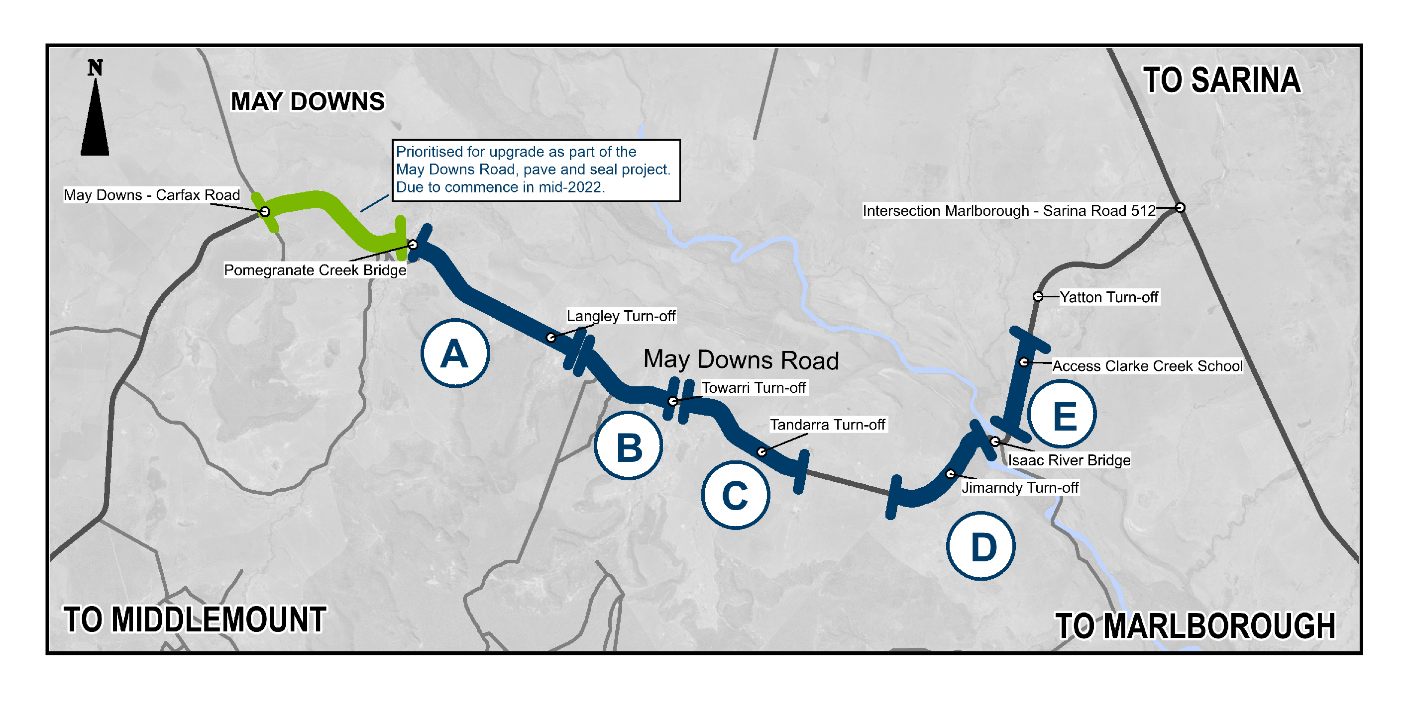
  1. Mackay Port Access, Bruce Highway to Mackay - Slade Point Road, construct new two-lane road

    The Mackay Port Access will join the Mackay Ring Road project, Mackay Northern Access Upgrade project, the Mackay Ring Road to Bald Hill Connection project for connection from the Bruce Highway at...

    No image supplied
  2. Mackay Ring Road

    The need for the Ring Road was identified to keep pace with the rate of growth of the Mackay area and to better prepare the region for future growth...

    Pioneer River construction Mackay Ring Road
  3. Mackay – Bucasia Road, capacity upgrades and duplication planning

    Planning is underway to identify potential future upgrades to Mackay – Bucasia Road to improve congestion, safety, and flooding impacts on this vital link to the Northern Beaches...

    No image supplied
  4. Maleny – Kenilworth Road (Cambroon), various locations, widen pavement

    Widening and sealing the single sections of Maleny-Kenilworth Road in the Conondale and Cambroon areas to provide one sealed laned in each direction...

    No image supplied
  5. Manly Boat Harbour

    The Manly Boat Harbour is an integral part of Manly's social, cultural and economic landscape. We want to better understand your ideas for the harbour to help guide future activities and community...

    Manly Boat Harbour Aerial
  6. Mareeba – Dimbulah Road, Mareeba Heavy Vehicle Bypass, planning

    This project will complete planning for the southern section of the Mareeba Bypass and review the alignment of the northern section...

    Vehicles travelling along Mareeba–Dimbulah Road locally known as Byrnes Street
  7. Maroochydore - Mooloolaba Road and Ocean Street, improve intersection

    Horton Parade Maroochydore Road Ocean Street and Beach Road intersection pedestrian safety improvements...

    No image supplied
  8. Maroochydore - Noosa Road (David Low Way), Bli Bli Bridge upgrade, planning project

    Planning will identify a preferred option for a future upgrade that improves efficiency, safety, and reliability for all road users...

    Aerial view of Bli Bli Bridge
  9. Maroochydore Road, Pike Street and Killick Street intersection upgrade, design

    The department has developed a preferred option for staged improvements to Maroochydore Road, Kunda Park to improve safety and relieve congestion...

    No image supplied
  10. Maroochydore-Noosa Road (Bradman Avenue), Diura Street and Denna Street, improve intersections

    The department will deliver safety improvements at the intersections of Bradman Avenue with Diura Street and Denna Street, Maroochydore...

    No image supplied
  11. Maroochydore–Noosa Road Route Strategy and Link Plan

    The Department of Transport and Main Roads (TMR) is undertaking planning to identify priorities for the full length of Maroochydore–Noosa Road which runs from Ocean Street, Maroochydore to Emu...

    No image supplied
  12. Maryborough - Hervey Bay Road and Pialba - Burrum Heads Road, upgrade intersection

    The Department of Transport and Main Roads is undertaking detailed design for an upgrade of the Maryborough-Hervey Bay Road and Pialba-Burrum Heads Road intersection in Eli Waters...

    No image supplied
  13. Maryborough-Hervey Bay Road, Ibis Boulevard and Fairway Drive, intersection upgrade, business case

    Maryborough-Hervey Bay Road/Ibis Boulevard/Fairway Drive intersection upgrade...

    No image supplied
  14. May Downs Road, pave and seal

    The May Downs Road, pave and seal project is delivering $8 million in road improvements to boost connectivity between the western and eastern parts of the Isaac Regional Council area...

    Map showing the location of work to be completed on the May Downs Road.
  15. Moggill Sub - Arterial Road, Centenary Motorway to Rafting Ground Reserve, active transport planning

    The department is undertaking active transport planning for the Moggill Sub-Arterial Road, Rafting Ground Reserve to Centenary Highway...

    Project location runs along Moggill Road from the intersection of Rafting Ground Road and Moggill Roadd to the Centenary Motorway
  16. Monto - Mount Perry Road progressive sealing

    A combined funding amount of $16 million has been allocated under the Australian Government's Road Safety Program and the State Road Network Upgrades investment program to progressively seal sections...

    No image supplied
  17. Mooloolaba Boat Harbour entrance, long-term solution

    We are planning for a long-term solution to improve safety and accessibility for all users...

    No image supplied
  18. Mooloolaba Road and Sugar Road intersection, upgrade

    The intersection will be upgraded to minimise delays, congestion and queuing and improve safety along this busy section of the network...

    No image supplied
  19. Mooloolaba to Maroochydore cycleway, design cycleway

    We are partnering with the Sunshine Coast Council to deliver the Mooloolaba to Maroochydore Cycleway...

    Map showing the proposed alignment for Mooloolaba to Maroochydore Cycleway