
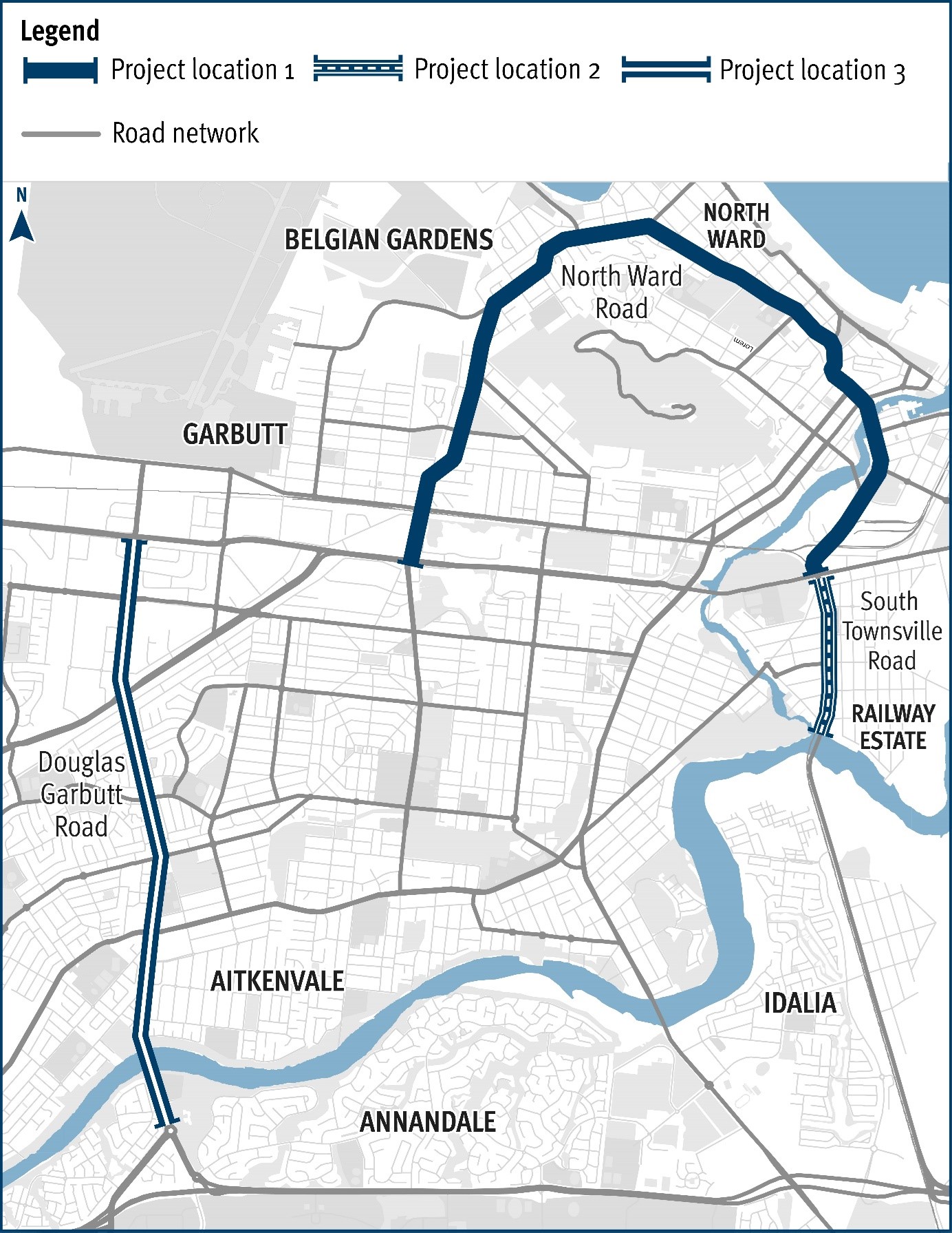
Douglas – Garbutt Road (Townsville), various locations (Stage 1), improve intersections
Safety upgrades will be carried out at various locations along Douglas – Garbutt Road.
Construction
Safety upgrades will be carried out at various locations along Douglas – Garbutt Road.
Construction
Safety upgrades will be carried out at various locations along North Ward Road.
ConstructionThe Department of Transport and Main Roads (TMR) is undertaking safety improvement works at various locations across three state-controlled roads in Townsville:
The works are being delivered under the High Risk Roads program which is a state-funded initiative to address key safety concerns for the whole of a road segment or route.
Construction works started in late March 2023 and will continue until late 2023.
These projects are funded by the Queensland Government through the High Risk Roads Program. 1. South Townsville Road, (Stage 1) various locations, improve intersections with $3.012 million invested by the Queensland Government. 2. North Ward Road (Townsville), various locations, (Stage 1) improve intersections with $9.191 million invested by the Queensland Government. 3. Douglas Garbutt Road (Townsville), various locations, (Stage 1) improve intersections with $13.562 million invested by the Queensland Government.
The intersection of Beerburrum Road, Twin View Road, and English Street in Elimbah is being upgraded as part of the Queensland Government's Targeted Road Safety Program. The upgrade will include the installation of traffic signals to improve safety and provide safer turning movements and crossing opportunities for all road users.

The Queensland Government is delivering the design for an upgraded link for bicycle riders and pedestrians between Kurilpa Bridge and Victoria Bridge on the Bicentennial Bikeway.
The Brisbane Valley Highway upgrade intersections project is part of the South East Queensland (SEQ) City Deal—an agreement between the Australian Government, Queensland Government, and Somerset Regional Council. This project aims to enhance connectivity and safety along the Brisbane Valley Highway, a critical freight and commuter corridor linking Somerset with Greater SEQ.
With increasing traffic volumes, the highway has seen a rise in intersection crashes. This project will deliver targeted safety improvements to reduce crash risks, improve traffic flow, and support the region’s long-term growth and connectivity.

The Queensland Government is upgrading the Bruce Highway, where it joins the Gateway Motorway and Gympie Arterial Road, south of the Pine River to improve traffic flow and safety.

The Queensland Government is upgrading the Bruce Highway (Brisbane-Gympie), Gateway Motorway to Dohles Rocks Road in stages to improve traffic flow and safety.
The Queensland Government is improving flood immunity, safety, and efficiency of the Bruce Highway and future-proofing the road to cater for growing traffic volumes. The Tiaro Bypass will also remove a significant number of heavy vehicles from Tiaro township, improving safety and liveability for residents.
The Queensland Government is committed to building back better and ensuring the state-controlled road network is more resilient to future disasters, safeguarding communities and supporting economic recovery.
Design is progressing for the future duplication of Caboolture-Bribie Island Road from west of Hickey Road to west of King Johns Creek. The project includes signalising the Hickey Road intersection.

A business case has been completed, and the project is now progressing through the detailed design phase for the new Bribie Island Bridge

The Queensland Government is undertaking a $300 million project to duplicate the Cairns Western Arterial Road between Redlynch Connector Road and Captain Cook Highway. This upgrade will transform the road into a 4-lane carriageway, improving safety, capacity, and traffic flow for the region.

The Queensland Government is progressing with a major upgrade of the Caloundra Road, Kawana Way Link Road, and Bells Creek Arterial Road intersection to deliver significant congestion relief and safety improvements for the Sunshine Coast region.

The Cannon Hill Shopping Centre bus facility is proposed to be upgraded.
The Buaraba Creek timber bridge replacement project will improve safety and network reliability by replacing the existing narrow, timber bridge (Neithe Bridge) with a new wider, two-lane, concrete structure in the same location.
Safety improvements to the intersection of Deception Bay, Bay Avenue and Moreton Downs Drive intersection, Deception Bay.
Safety upgrades will be carried out at various locations along Douglas – Garbutt Road.
The department is undertaking safety improvement works at various locations across Garbutt – Upper Ross Road (locally known as Thuringowa Drive and Riverway Drive) from the Halliday Street/Thuringowa Drive intersection to Gouldian Avenue/Riverway Drive intersection.
The Queensland Government is upgrading the Gateway Motorway from Bracken Ridge to the Pine River to improve traffic flow and safety.

Detailed design has started for future expansion of parking facilities at Gaythorne station.

This upgrade is part of the Queensland Government's commitment to improving road safety and traffic flow in the metropolitan region. This project aims to address congestion and enhance safety for all road users.
Design to rehabilitate and widen priority sections of Kin Kin Road (locally known as Pomona Kin Kin Road) is progressing. This will improve safety and ride quality and reduce maintenance costs.
The Mackay–Bucasia Road and Golf Links Road intersection in Beaconsfield is undergoing detailed design for an upgrade.
Planning has been completed to upgrade active transport facilities on Moggill Road, between Witton Road and the Centenary Motorway off-ramp.
The department is partnering with Sunshine Coast Council to deliver the Mooloolaba to Maroochydore cycleway which will provide a bicycle path connecting Mooloolaba to Maroochydore.

The Queensland Government is committed to improving safety on the New England Highway at Cooyar.
Safety upgrades will be carried out at various locations along North Ward Road.
Work is now complete on the Pacific Motorway, Eight Mile Plains to Daisy Hill Upgrade, which has improved 8kms of the Pacific Motorway (M1) between the Gateway Motorway and Watland Street.

The Queensland Train Manufacturing Program will build 65 new six-car passenger trains at a purpose-built manufacturing facility in Torbanlea. The new, modern train fleet will provide passengers with more efficient, reliable, and accessible travel across South East Queensland.

A separated cycle track is being designed along Taylor Street, between Tor and Boundary streets, as part of the Toowoomba–Cecil Plains Road (Taylor Street) bikeway project.
Last updated: 19 July 2024