
Mount Lindesay Highway (Brisbane - Beaudesert), Johanna Street to South Street (Jimboomba), duplication
The Mount Lindesay Highway at Jimboomba has been upgraded to improve safety, reduce congestion and improve shared path connectivity.
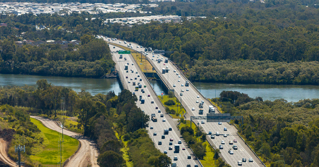
CompletedThe Mount Lindesay Highway at Jimboomba has been upgraded to improve safety, reduce congestion and improve shared path connectivity.
CompletedThe Mount Lindesay Highway is being upgraded to improve safety and efficiency.
The Mount Lindesay Highway is one of Queensland's busiest highways. Currently there are between 58,000 and 25,000 vehicles per day using sections of the highway between Browns Plains and Jimboomba.
The 10-year strategic plan outlines the priority infrastructure projects for the Mount Lindesay Highway between 2018–2028.
| Upgrade project | Status | |
| Mount Lindesay Highway (Brisbane-Beaudesert), Logan Motorway to Park Ridge Road, Combined Planning | ||
| Logan Motorway to Middle Road | Currently in planning 2024-28 | |
| Green Road/Coronation Road Interchange | Currently in planning 2024-28 | |
| Mount Lindesay Highway (Brisbane-Beaudesert), North Mclean to Jimboomba, Combined Planning | ||
| Greenbank Road to Stockleigh Road | Currently in planning 2024-28 | |
| Chambers Flat Road to Greenbank Road | Currently in planning 2024-28 | |
| Stockleigh Road to Camp Cable Road | Currently in planning 2024-28 | |
| Johanna Street to South Street through Jimboomba | Currently in delivery phase | |
| South Street to Cedar Vale Road | Planning beyond 2025-28 | |
| Cedar Vale Road to Beaudesert | Planning beyond 2026 | |
| Stoney Camp Road to Chambers Flat Road | Delivered 2023 |
|
| Jimboomba to Beaudesert safety improvements | Delivered 2021-22 | |
| South Maclean safety improvements | Delivered 2020 |
|
| Camp Cable Road to Johanna Street, Jimboomba | Delivered 2020 |
|
| Rosia Road to Stoney Camp Road | Delivered 2020 |
|
| North Maclean safety improvements | Delivered 2019 | |
| Beaudesert Town Centre Bypass | Delivered 2017 | |
| Camp Cable Road intersection | Delivered 2016 | |
| Millstream Road intersection | Delivered 2015 | |
To improve safety and reduce congestion the Mount Lindesay Highway is being upgraded as funding becomes available. Find more information:
The intersection of Beerburrum Road, Twin View Road, and English Street in Elimbah is being upgraded as part of the Queensland Government's Targeted Road Safety Program. The upgrade will include the installation of traffic signals to improve safety and provide safer turning movements and crossing opportunities for all road users.

The Queensland Government is delivering the design for an upgraded link for bicycle riders and pedestrians between Kurilpa Bridge and Victoria Bridge on the Bicentennial Bikeway.
The Brisbane Valley Highway upgrade intersections project is part of the South East Queensland (SEQ) City Deal—an agreement between the Australian Government, Queensland Government, and Somerset Regional Council. This project aims to enhance connectivity and safety along the Brisbane Valley Highway, a critical freight and commuter corridor linking Somerset with Greater SEQ.
With increasing traffic volumes, the highway has seen a rise in intersection crashes. This project will deliver targeted safety improvements to reduce crash risks, improve traffic flow, and support the region’s long-term growth and connectivity.

The Queensland Government is upgrading the Bruce Highway, where it joins the Gateway Motorway and Gympie Arterial Road, south of the Pine River to improve traffic flow and safety.

The Queensland Government is upgrading the Bruce Highway (Brisbane-Gympie), Gateway Motorway to Dohles Rocks Road in stages to improve traffic flow and safety.
The Queensland Government is improving flood immunity, safety, and efficiency of the Bruce Highway and future-proofing the road to cater for growing traffic volumes. The Tiaro Bypass will also remove a significant number of heavy vehicles from Tiaro township, improving safety and liveability for residents.
The Queensland Government is committed to building back better and ensuring the state-controlled road network is more resilient to future disasters, safeguarding communities and supporting economic recovery.
Design is progressing for the future duplication of Caboolture-Bribie Island Road from west of Hickey Road to west of King Johns Creek. The project includes signalising the Hickey Road intersection.

A business case has been completed, and the project is now progressing through the detailed design phase for the new Bribie Island Bridge

The Queensland Government is undertaking a $300 million project to duplicate the Cairns Western Arterial Road between Redlynch Connector Road and Captain Cook Highway. This upgrade will transform the road into a 4-lane carriageway, improving safety, capacity, and traffic flow for the region.

The Queensland Government is progressing with a major upgrade of the Caloundra Road, Kawana Way Link Road, and Bells Creek Arterial Road intersection to deliver significant congestion relief and safety improvements for the Sunshine Coast region.

The Cannon Hill Shopping Centre bus facility is proposed to be upgraded.
The Buaraba Creek timber bridge replacement project will improve safety and network reliability by replacing the existing narrow, timber bridge (Neithe Bridge) with a new wider, two-lane, concrete structure in the same location.
Safety improvements to the intersection of Deception Bay, Bay Avenue and Moreton Downs Drive intersection, Deception Bay.
The department is undertaking safety improvement works at various locations across Garbutt – Upper Ross Road (locally known as Thuringowa Drive and Riverway Drive) from the Halliday Street/Thuringowa Drive intersection to Gouldian Avenue/Riverway Drive intersection.
Detailed design has started for future expansion of parking facilities at Gaythorne station.

This upgrade is part of the Queensland Government's commitment to improving road safety and traffic flow in the metropolitan region. This project aims to address congestion and enhance safety for all road users.
Design to rehabilitate and widen priority sections of Kin Kin Road (locally known as Pomona Kin Kin Road) is progressing. This will improve safety and ride quality and reduce maintenance costs.
The Mackay–Bucasia Road and Golf Links Road intersection in Beaconsfield is undergoing detailed design for an upgrade.
Planning has been completed to upgrade active transport facilities on Moggill Road, between Witton Road and the Centenary Motorway off-ramp.
The department is partnering with Sunshine Coast Council to deliver the Mooloolaba to Maroochydore cycleway which will provide a bicycle path connecting Mooloolaba to Maroochydore.

The Mount Lindesay Highway at Jimboomba has been upgraded to improve safety, reduce congestion and improve shared path connectivity.
The Queensland Government is committed to improving safety and efficiency on the New England Highway at Cooyar.
Work is now complete on the Pacific Motorway, Eight Mile Plains to Daisy Hill Upgrade, which has improved 8kms of the Pacific Motorway (M1) between the Gateway Motorway and Watland Street.

The Queensland Train Manufacturing Program will build 65 new six-car passenger trains at a purpose-built manufacturing facility in Torbanlea. The new, modern train fleet will provide passengers with more efficient, reliable, and accessible travel across South East Queensland.

A separated cycle track is being designed along Taylor Street, between Tor and Boundary streets, as part of the Toowoomba–Cecil Plains Road (Taylor Street) bikeway project.
Last updated: 24 August 2024