
Coomera Connector Stage 1, Coomera to Nerang
Stage 1 of the Coomera Connector, between Coomera and Nerang, is around 16km and is now open to traffic between Shipper Drive and Helensvale Road.
Construction
Stage 1 of the Coomera Connector, between Coomera and Nerang, is around 16km and is now open to traffic between Shipper Drive and Helensvale Road.
Construction
Work is now complete on the Pacific Motorway, Eight Mile Plains to Daisy Hill Upgrade, which has improved 8kms of the Pacific Motorway (M1) between the Gateway Motorway and Watland Street.
Detailed design
The $1.5 billion Pacific Motorway Varsity Lakes to Tugun (VL2T) project to upgrade 10km of the M1 has been completed.
CompletedThe Pacific Motorway M1 is one of Australia’s busiest highways and is a national freight route.

We want you to get where you're going more reliably, so you can spend more time doing the things you love.
The upgrade and widening of the Pacific Motorway M1 is being delivered in strategic priority stages as funding becomes available, based on traffic volumes and best value for money.
| Project | Status |
| Coomera interchange | Completed |
| Coomera Connector Stage 1 | Construction |
| Coomera Connector Future Stages | Planning |
| Daisy Hill to Logan Motorway | Planning |
| Eight Mile Plains to Daisy Hill | Construction |
| Logan Motorway to Palm Beach |
Completed |
| Loganholme to Pimpama |
Planning |
| M1/M3 Gateway Merge | Completed |
| Mudgeeraba to Robina |
Completed |
| Mudgeeraba to Varsity Lakes | Completed |
| Ormeau interchange (Exit 45) southbound off-ramp | Completed |
| Ormeau interchange (North) | Planning |
| Pimpama interchange (Exit 49) | Construction |
| Varsity Lakes to Tugun (Exit 85 to 95) |
Construction |
| Worongary to Mudgeeraba |
Completed |
| Yatala South Interchange (Exit 41) | Completed |
| Main Street overpass safety improvements |
Planning |
| Logan Motorway to Nerang |
Planning |
Bowen State Boat Harbour is a key strategic maritime asset in the northern Whitsunday region, providing deep water access for commercial and recreational vessels, a place for public recreation and supporting a range of local maritime businesses, marinas and fishing fleets.

Planning is underway for around 2km of overtaking opportunities and upgrades to pavement and lighting at the Gunyarra Road intersection.
This project has been completed and provides Intelligent Transport System infrastructure at various locations along the Bruce Highway between Pine River and Cairns.
Coomera Connector (Future Stages), between Loganholme and Coomera, is around 29km and will connect with Coomera Connector Stage 1.

Stage 2 of the Coomera Connector, between Pimpama and Coomera, is around 5km and is the next priority section for planning and design.
Stage 1 Central of the Coomera Connector is the 8km section from Helensvale Road to Smith Street Motorway.
Stage 1 North of the Coomera Connector is the 4km section from Shipper Drive to Helensvale Road.
Stage 1 South of the Coomera Connector is the 4km section from Smith Street Motorway to Nerang-Broadbeach Road.
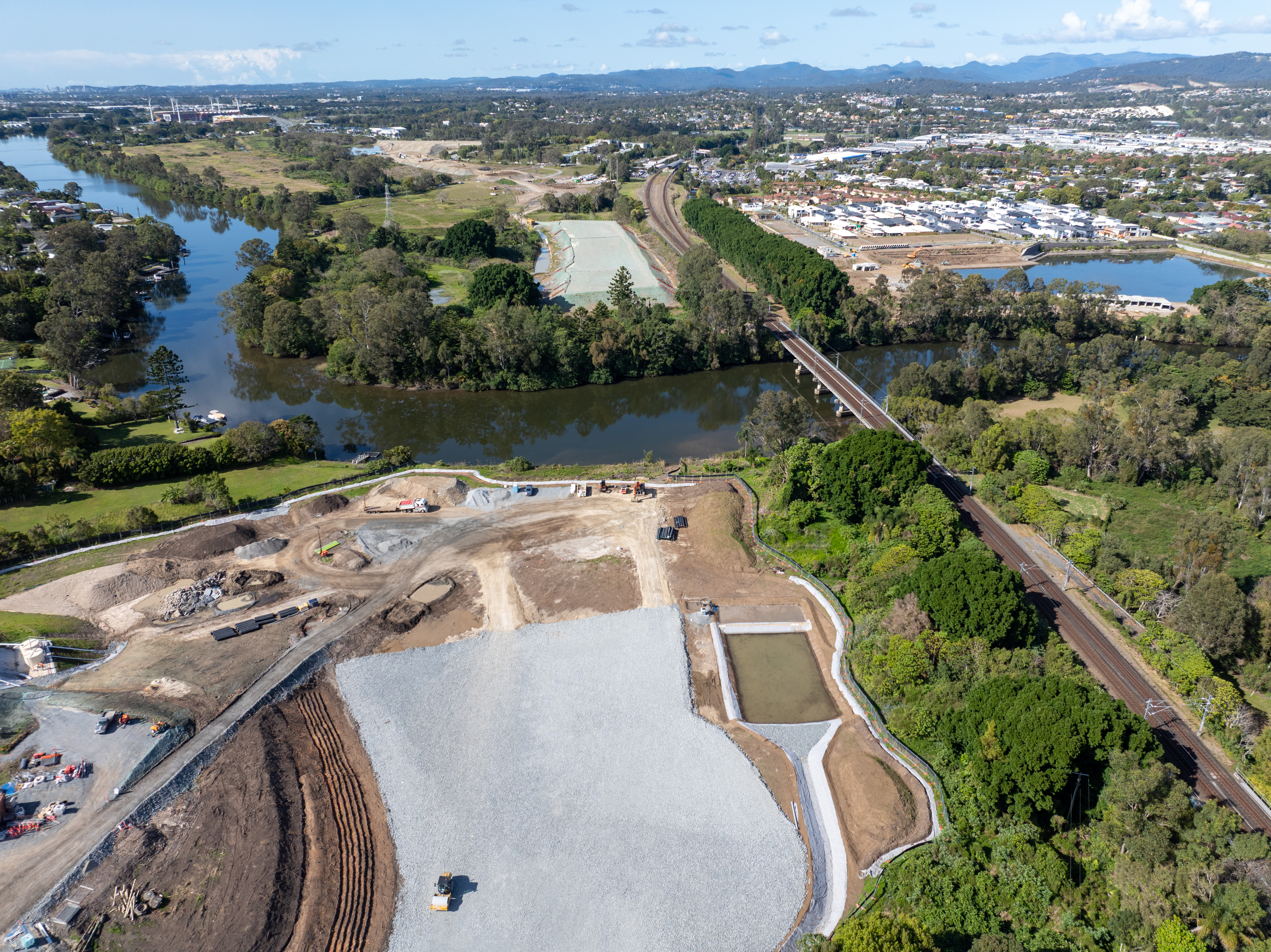
Stage 1 of the Coomera Connector, between Coomera and Nerang, is around 16km and is now open to traffic between Shipper Drive and Helensvale Road.
The Queensland Government is undertaking works to widen and strengthen priority sections of around 9km of the Gregory Developmental Road.
The Mackay–Bucasia Road and Golf Links Road intersection in Beaconsfield is undergoing detailed design for an upgrade.
The proposed Mackay Port Access will provide a direct link for freight movements from the Mackay Port to the Mackay Ring Road, and west to the Bowen Basin coal fields via the Walkerston Bypass and Peak Downs Highway.
The Mackay Ring Road to Bald Hill Road Connection Project delivers a significant upgrade to the Brue Highway.

Planning is complete and has identified future upgrades to Mackay – Bucasia Road to improve congestion, safety, and flooding impacts on this vital link to the Northern Beaches.
The Next Generation Traffic Signalling Program is an initiative aimed at transforming traffic signal infrastructure across Queensland.
Planning is underway for the Pacific Motorway (M1) – Daisy Hill to Logan Motorway upgrade. This section of the M1 cannot accommodate current traffic volumes and, as a result, experiences frequent and prolonged periods of congestion and poor travel time reliability.

Planning and construction is underway for short and long-term upgrades of various interchanges on the Pacific Motorway (M1)
The $1.5 billion Pacific Motorway Varsity Lakes to Tugun (VL2T) project to upgrade 10km of the M1 has been completed.
Work is now complete on the Pacific Motorway, Eight Mile Plains to Daisy Hill Upgrade, which has improved 8kms of the Pacific Motorway (M1) between the Gateway Motorway and Watland Street.
The Exit 49 interchange upgrade has delivered significant improvements in safety and traffic flow efficiency by keeping traffic moving through the improved interchange and reducing queuing.
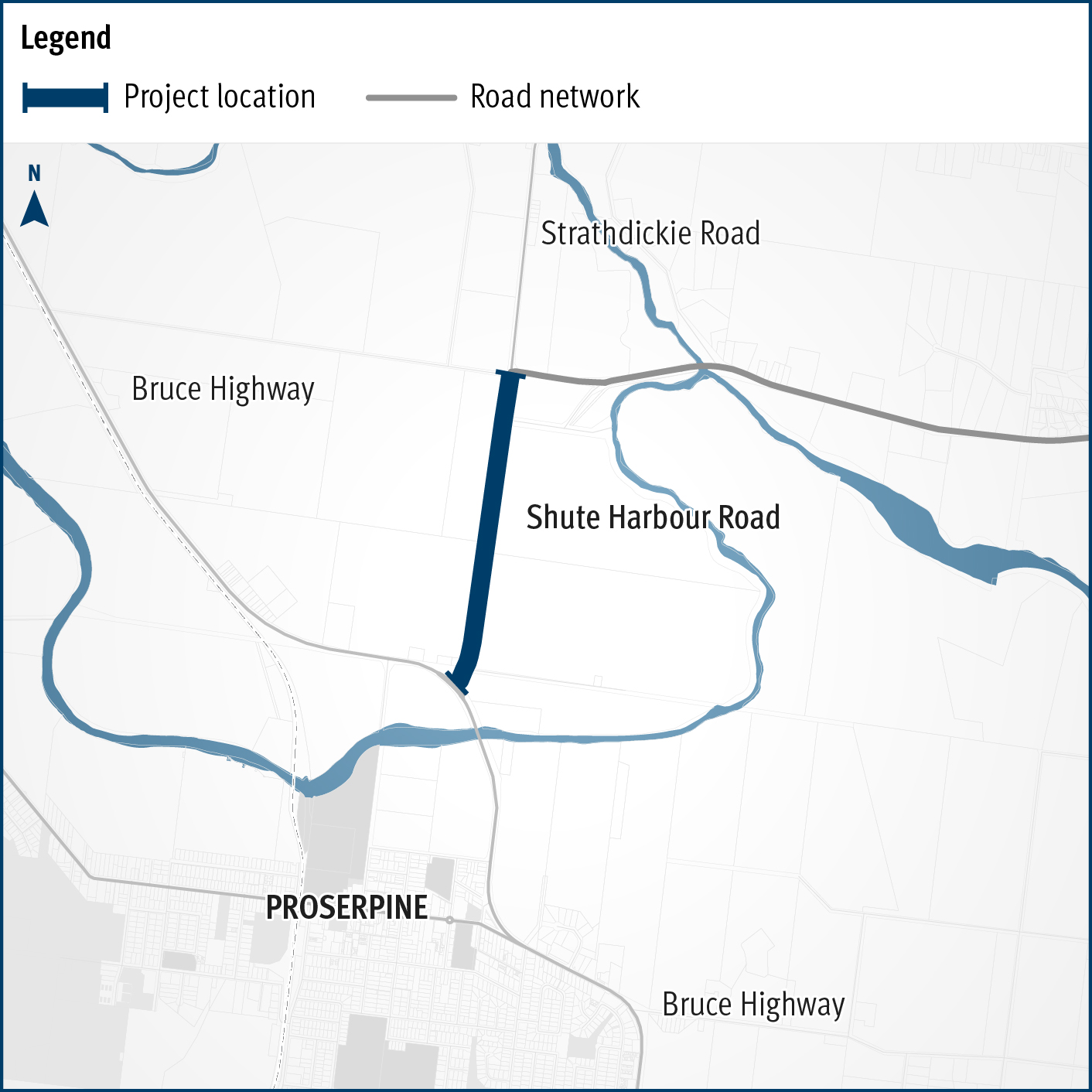
A capacity upgrade is in development to complement the planned Proserpine-Shute Harbour Road Upgrade between Paluma Road and Valley Drive.
Upgrades to this key arterial road in the Whitsunday Region include flood immunity improvements at Hamilton Plains and a capacity upgrade between Paluma Road and Valley Drive in Cannonvale.
The Walkerston Bypass is a new 2-lane rural highway connecting Peak Downs Highway west of Walkerston to the Mackay Ring Road near Paget.
Last updated: 12 March 2025