Warrego Highway Upgrade Program

The Warrego Highway forms a critical part of the National Land Transport Network and is Queensland's principal east-west freight route. 

The highway connects Darwin and Melbourne to the major import and export hubs of Port of Brisbane, Brisbane Airport, Wellcamp Airport and the future Inland Rail intermodal terminals at Ipswich and Toowoomba.

Infrastructure Australia has recognised the Warrego Highway as a priority initiative on its 2021 Infrastructure Priority List of nationally significant investments, and the highway is part of the nationally accredited Key Freight Route network.

The section of highway between Toowoomba and Ipswich has also been identified as a Road of Strategic Importance by the Australian Government.

The Warrego Highway is a vital transport link for cities such as Brisbane, Ipswich and Toowoomba and the rural communities of the West Moreton, Lockyer Valley, Darling Downs, Maranoa and South West Queensland.  

At present the primary drivers of transport needs are:

  • providing access between local communities and inter-regional connections between Toowoomba, Brisbane and Ipswich – three of the largest and fastest growing areas in Queensland
  • enabling freight movement on the National Land Transport Network
  • supercharging a SEQ Trade and Enterprise Spine between the Toowoomba Trade Gateway and the Australia TradeCoast
  • strategic link for current defence mobilisation and a key transport link between three defence force bases (for example RAAF Amberley Base, Oakey Army Aviation Centre and Borneo Barracks)
  • supporting response to national emergencies/disasters of a local, regional and national scale.

Consequently, the Warrego Highway is one of Queensland's busiest commuter and freight highways in the state. Between Ipswich and Toowoomba there are between 25,000 and 60,000 vehicles per day and up to 20% heavy vehicles. The Warrego Highway Upgrade Strategy (2012) outlines the priority infrastructure projects for the Warrego Highway between Dinmore and Charleville.

Most recently under Tranche 1 of the Warrego Highway Upgrade Program, the East and West Creek culvert upgrades project was finalised, completing delivery of the initial $635 million tranche.

Tranche 2 of the Warrego Highway Upgrade Program included the Toowoomba Bypass which is a 41km alternative crossing of the Toowoomba Range that was completed in 2019.

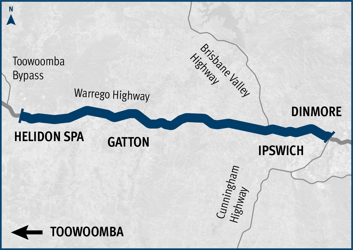
Tranche 3 includes planning for upgrades between Dinmore and Helidon Spa. Planning is scheduled to occur between 2022 and 2032. 

Benefits

  • Improves safety
  • Increases capacity
  • Improves network efficiency
  • Increases traffic flow
  • Reduces peak hour congestion
  • Improves flood immunity
  • Reduces travel time
  • Contributes to economy
  • Contributes to regional growth
  • Improves ride quality

Funding

The Warrego Highway funding commitment is jointly funded by the Australian and Queensland governments. Project details and timing subject to further planning and negotiation with the Australian Government, noting the Queensland Government’s initial priority is upgrading the Mount Crosby Road interchange. Investment ID 1202509.

Funding figures as at QTRIP 2023–24 to 2026–27 (June 2023).


Total investment
$585.2 million
Australian Government
$467.6 million
Queensland Government
$117.6 million
To enable further implementation of the Warrego Highway Upgrade Strategy, planning has started for projects between Dinmore and Helidon Spa. This is complemented by the Warrego Highway East Master Plan that delivers corridor preservation and sequencing of projects between these 2 locations. Projects previously completed under the Warrego Highway Upgrade Program include:
  • Brigalow – Chinchilla upgrade was completed in May 2017 and was a $33.5 million construction project to widen 11km of the highway on the eastern approach to Chinchilla.
  • Carroll Creek Culvert Replacement was completed in May 2019 and was a $4.9 million construction project to replace the culverts at the site west of Yuleba, improving productivity for freight operators.
  • Chinchilla open level crossing upgrade was completed in August 2020 and was a $19 million construction project, improving safety at the open level crossing in Chinchilla and install traffic signals at the Colamba Street intersection.
  • Chinchilla heavy vehicle route strategy was completed in late 2019 and was a $1 million planning project to investigate the need for a future heavy vehicle route for Chinchilla.
  • Dalby eastern access upgrade was completed in November 2018 and was a $56 million construction project to improve motorist and pedestrian safety at major intersections through the eastern half of Dalby.
  • Dalby western access upgrade was completed in November 2018 and was a $59 million construction project to improve safety at major intersections and accesses from nearby industrial developments on the western side of Dalby. 
  • Dalby to Miles pavement widening and safety upgrade was completed in December 2019 and was a $63.64 million construction project to improve safety by widening the road and installing wide centre line treatments.
  • Dalby - Miles overtaking lanes were completed in March 2019 and was a $35 million construction project to provide additional overtaking lanes.
  • Drillham – Palardo upgrade was completed in May 2020 and was a $13 million construction project to widen narrow sections of the highway to a safe standard for heavy vehicles.
  • Jingi Jingi Creek bridge upgrade was completed in August 2017 and was a $10.6 million construction project to replace the deteriorated culverts and build a new concrete bridge.
  • Jondaryan – Sabine Road intersection upgrade was completed in January 2017 and was a $3.9 million construction project to upgrade the intersection to provide heavy vehicle access to the highway.
  • Miles western access upgrade was completed in October 2018 and was an $11.9 million construction project to widen and rehabilitate the highway through the town on the western outskirts.
  • Oakey – Dalby overtaking lanes were completed in September 2017 and was a $36.8 million construction project to provide additional overtaking lanes at regular intervals in both directions.
  • Oakey – Miles safety upgrade was completed in December 2020 and was a $63.64 million construction project to repair additional key sections of highway, install wide centre line and flatten slopes off the road edges. 
  • Oakey to Miles safety upgrade stage 2 was completed in December 2019 and was an $11.65 million construction project to improve safety with additional stopping bays, removing dangerous drop-offs and roadside hazards.
  • Toowoomba Bypass was opened to traffic in September 2019 and was a $1.6 billion construction project to provide an alternative crossing of the Toowoomba Range.
  • Toowoomba – Oakey duplication stage 1 was completed in September 2017 and was a $62.7 million construction project to extend the 4-lane Warrego Highway from Nugent Pinch Road to west of Charlton.
  • Toowoomba – Oakey duplication stage 2 was completed in March 2018 and was a $71.1 million construction project extending the 4-lane highway from stage 1 west to Kingsthorpe.
  • Toowoomba – Oakey duplication stage 3 was completed in July 2018 and was a $2 million planning project to investigate the proposed 4-lane highway from Kingsthorpe to Oakey.
  • Warrego Highway East and West Creek culvert upgrades were completed in November 2020 with $21.3 million allocated to improve flood immunity in the Toowoomba central business district.

Project map

Project map

32 Projects in Warrego Highway Upgrade Program

Bunya Highway (Dalby – Kingaroy) and Patrick Street, upgrade intersection

The Queensland Government is implementing cost-effective safety measures to minimise the risk of vehicle and pedestrian incidents, as well as rear-end collisions caused by vehicles turning right across oncoming traffic at this intersection.

  • Darling Downs District
  • Construction
No image supplied

Cunningham Highway (Ipswich – Warwick), Tregony to Maryvale, improve safety

This project is delivering safety improvements to provide a better driving experience for all road users and aims to reduce the risk of fatal and serious injury crashes.

  • Darling Downs District
  • Construction
No image supplied

Cunningham Highway (Warwick – Inglewood), improve safety

The project involved upgrading infrastructure to improve safety, provide a better driving experience for all road users and reduce the risk of fatal and serious injury crashes.

  • Darling Downs District
  • Completed
No image supplied

D'Aguilar Highway network safety planning

The Queensland Government is investigating ways to improve safety for motorists on the D’Aguilar Highway in the Toowoomba Region.

  • Darling Downs District
  • Planning
No image supplied

Esk-Hampton Road, Perseverance Creek, replace culvert

This project involves replacing a failing culvert on Esk-Hampton Road at Perseverance Creek.

  • Darling Downs District
  • Construction
No image supplied

Gatton-Helidon Road (Spencer Street) and William Street intersection, improve safety

The Queensland Government is undertaking an upgrade of the Spencer Street and William Street intersection in Gatton to improve traffic movement, safety and rideability for road users, pedestrians and bike riders.

  • Darling Downs District
  • Construction
No image supplied

Gatton–Clifton Road maintenance, Mount Whitestone

A large slow-moving landslide is affecting a section of Gatton–Clifton Road at Mount Whitestone.

  • Darling Downs District
  • Construction
No image supplied

Gatton–Clifton Road planning, Mount Whitestone

This planning project aims to develop long-term strategies to manage the impacts of a slow-moving landslide at Mount Whitestone.

  • Darling Downs District
  • Planning
Gatton–Clifton Road Realignment Planning, Mount Whitestone location

Gatton–Esk Road, flood resilience, planning

Planning is underway to improve flood immunity of Gatton–Esk Road at Lockyer Creek.

  • Darling Downs District
  • Planning
No image supplied

Gatton–Helidon Road, improve safety

Traffic flow and safety has been improved on Gatton–Helidon Road.

  • Darling Downs District
  • Completed
No image supplied

Gore Highway (Millmerran – Goondiwindi), Wyaga Creek, upgrade floodway

The new bridge over Wyaga Creek at Kilbronae has improved flood immunity, safety and efficiency on the Gore Highway between Millmerran and Goondiwindi, which is one of Queensland's most important transport links.

  • Darling Downs District
  • Construction
No image supplied

Gore Highway (Millmerran – Goondiwindi), improve safety

The Queensland Government is installing safety treatments to reduce the frequency of vehicle incidents due to driver fatigue.

  • Darling Downs District
  • Construction
No image supplied

Gore Highway (Toowoomba – Millmerran) and Toowoomba–Athol Road, improve safety

This project involves safety upgrades to the Gore Highway (Toowoomba – Millmerran) and Toowoomba–Athol Road.

  • Darling Downs District
  • Construction
No image supplied

New England Highway (Toowoomba - Warwick), improve safety

The Queensland Government is improving safety on the New England Highway to reduce the risk of fatal and serious injury crashes for all road users.

  • Darling Downs District
  • Construction
No image supplied

New England Highway (Yarraman - Toowoomba) Network Safety Planning

The Queensland Government is investigating future road infrastructure requirements to provide a better driving experience for all road users and to reduce the risk of fatal and serious injury crashes.

  • Darling Downs District
  • Planning
No image supplied

New England Highway (Yarraman - Toowoomba), Back Creek Bridge, upgrade bridge and approaches, design

The Queensland Government is committed to improving safety and efficiency on the New England Highway at Cooyar.

  • Darling Downs District
  • Detailed design
No image supplied

New England Highway (Yarraman – Toowoomba), Chalk Drive, Neil Street and Ruthven Street intersections, improve active transport facilities

Design is underway to improve safety for people walking and bike riding when crossing at the Chalk Drive, Ruthven and Victoria streets intersection and the Chalk Drive and Neil Street intersection.

  • Darling Downs District
  • Planning
No image supplied

New England Highway Bikeway, Highfields to Toowoomba CBD (Stages 1, 2 and 3)

The New England Highway Bikeway aims to provide a safe and accessible route for walking and cycling between Highfields and Toowoomba.

  • Darling Downs District
Bikeway between Mitchell Road and Toowoomba Christian College.

Next Generation Traffic Signalling Program

The Next Generation Traffic Signalling Program is an initiative aimed at transforming traffic signal infrastructure across Queensland.

  • Central West District
  • Darling Downs District
  • Far North District
  • Fitzroy District
  • Mackay Whitsunday District
  • Metropolitan District
  • North Coast District
  • North West Direct
  • Northern District
  • South Coast District
  • South West District
  • Wide Bay Burnett District
  • Construction
No image supplied

Southern Queensland 2022 flood reconstruction works completed

Repairs have been completed across southern Queensland after extensive and severe damage to the state-controlled road network was caused by multiple heavy rainfall and flooding events in 2022.

  • Darling Downs District
  • Metropolitan District
  • North Coast District
  • South Coast District
  • Wide Bay Burnett District
  • Completed
Landslip on Gold Coast - Springbrook Road

Toowoomba - Cecil Plains Road (Taylor Street), Tor Street to Boundary Street, design separated cycle track

A separated cycle track is being designed along Taylor Street, between Tor and Boundary streets, as part of the Toowoomba–Cecil Plains Road (Taylor Street) bikeway project.

  • Darling Downs District
  • Detailed design
No image supplied

Toowoomba Central Active Transport Link, business case

The Queensland Government has completed the business case for the Toowoomba Central Active Transport Link project.

  • Darling Downs District
  • Completed
No image supplied

Toowoomba City Cycle Paths, Karrool Street and Goode Street, construct active transport facilities

The Queensland Government has successfully completed the Toowoomba City Cycle Paths project. This project, delivered under the Active Transport Investment Program, has transformed Karrool Street and Goode Street into safer, more accessible, and connected transport routes for pedestrians and cyclists.

  • Darling Downs District
  • Construction
No image supplied

Toowoomba to Brisbane Passenger Rail

The Australian and Queensland governments have worked together to deliver the Toowoomba to Brisbane Passenger Rail Strategic Business Case.

  • Metropolitan District
  • Darling Downs District
  • Planning
No image supplied

Toowoomba to Gladstone Inland Rail Extension Strategic Business Case

The Australian and Queensland governments worked together to deliver the Toowoomba to Gladstone Inland Rail Extension Strategic Business Case.

  • Darling Downs District
  • Fitzroy District
  • Completed
Thumbnail image showing map of project area for proposed extension for Inland Rail from Toowoomba to Gladstone

Toowoomba–Athol Road between Toowoomba–Karara Road and Boundary Street South, upgrade planning

The Queensland Government has commenced planning to investigate ways to upgrade Toowoomba–Athol Road (locally known as Anzac Avenue) between and including the Toowoomba–Karara Road (locally known as Wyreema Road) and Boundary Street South intersections.

  • Darling Downs District
  • Planning

Toowoomba–Cecil Plains Road and Deuble/Heinemann Road intersection, planning

The Queensland Government is upgrading the intersection of Toowoomba–Cecil Plains, Deuble, and Heinemann roads to meet future transport needs.

  • Darling Downs District
  • Planning
No image supplied

Toowoomba–Cecil Plains Road, improve safety

Toowoomba-Cecil Plains Road is a critical transport route for the Darling Downs region, connecting agricultural communities to markets and essential services.

  • Darling Downs District
  • Construction
No image supplied

Warrego Highway (Ipswich - Toowoomba) and Mount Crosby Road interchange

The department has completed planning to identify a preferred option for the upgrade of the Warrego Highway – Mount Crosby Road interchange.

  • Metropolitan District
  • Pre-construction
Warrego Highway Mount Crosby upgrade project area aerial image

Warrego Highway (Ipswich - Toowoomba), Bremer River Bridge, strengthening

The Bremer River Bridge project involves critical rehabilitation works to extend the life of the existing westbound bridge, and enable removal of the speed restrictions currently in place.

  • Metropolitan District
  • Construction
Bremer River Bridge project location map

Warrego Highway (Toowoomba - Dalby) undertake safety improvements

The Queensland Government is improving safety along 60km of the Warrego Highway between Toowoomba and Dalby. This includes widening the road, flattening batter/roadside edges, adding new signage and line markings, removing roadside hazards, and installing turning lanes at Speed Road, Oakey.

  • Darling Downs District
  • Construction
No image supplied

Warrego Highway East master plan – Ipswich to Toowoomba

The Warrego Highway East master plan project will determine the future requirements of the Warrego Highway transport corridor.

  • Darling Downs District
No image supplied

Last updated: 21 May 2024