
Coomera Connector Stage 1, Coomera to Nerang
Stage 1 of the Coomera Connector, between Coomera and Nerang, is around 16km and is now open to traffic between Shipper Drive and Helensvale Road.
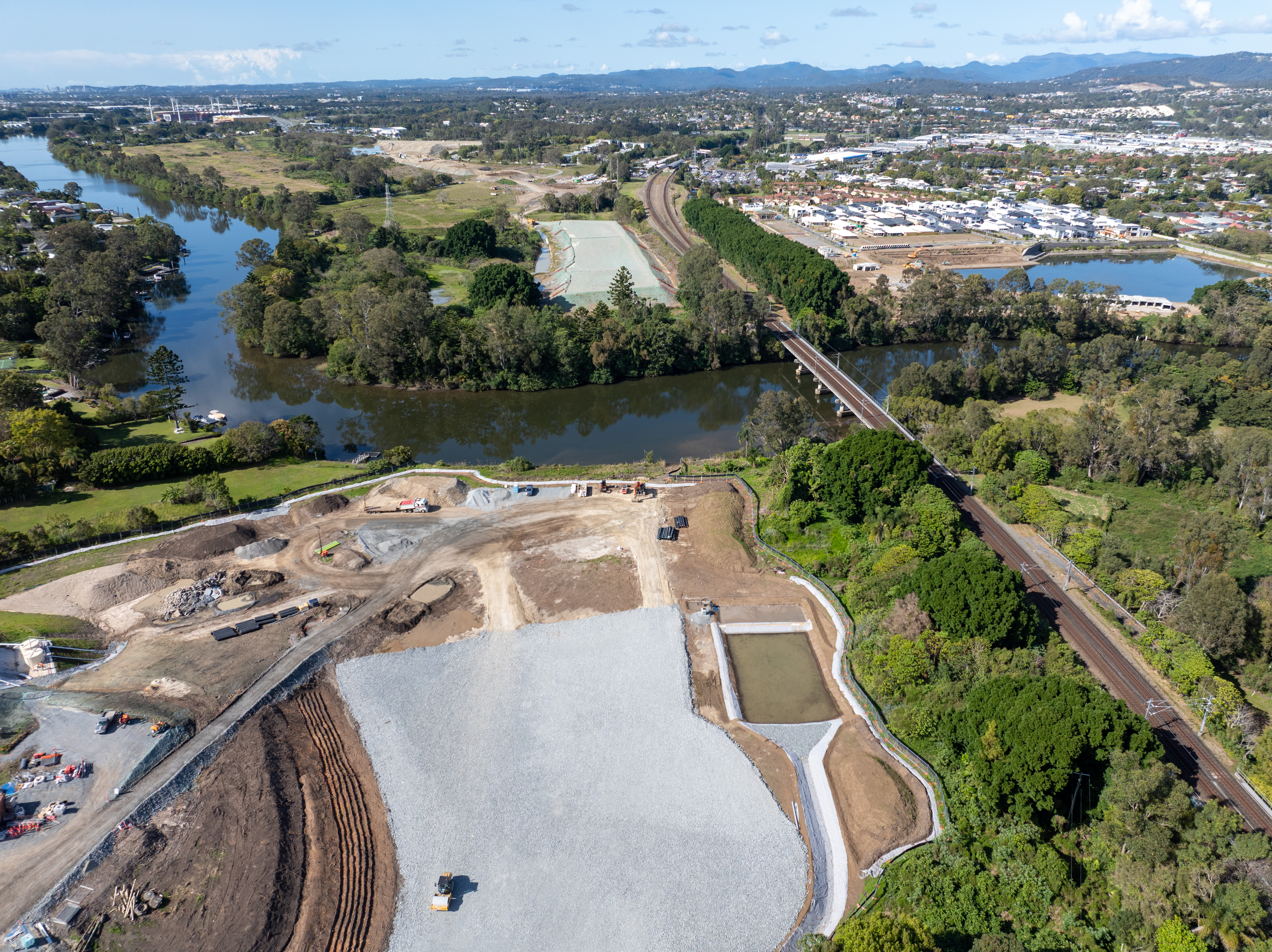
Construction
Stage 1 of the Coomera Connector, between Coomera and Nerang, is around 16km and is now open to traffic between Shipper Drive and Helensvale Road.
Construction
Coomera Connector (Future Stages), between Loganholme and Coomera, is around 29km and will connect with Coomera Connector Stage 1.
Planning
Stage 2 of the Coomera Connector, between Pimpama and Coomera, is around 5km and is the next priority section for planning and design.
PlanningThe Coomera Connector (M9) is a 45km north-south future motorway between Loganholme and Nerang, east of the Pacific Motorway (M1) and heavy rail line.
The new motorway will be an alternative to the M1, and support the rapidly growing residential and business communities in the northern Gold Coast and neighbouring Logan areas.
The full corridor extends between the Logan Motorway and Pacific Motorway interchange in Loganholme and Nerang–Broadbeach Road in Nerang.
The Coomera Connector is being delivered progressively:

The Coomera Connector will be a key link between Loganholme and the Gold Coast, where residential and business communities are growing rapidly.
Since the 1990s, the corridor has been identified in various public planning documents, such as published street directories, regional transport plans, planning studies and City of Gold Coast planning schemes. A joint 2015 study between the Queensland Government and City of Gold Coast confirmed the corridor as a future strategic transport link that will relieve traffic congestion on the M1 and surrounding local roads.
The Coomera Connector was formally declared a future state-controlled road, confirmed in the Queensland Government Gazette in 3 sections, the:
Three locations have since been identified for corridor amendments to improve outcomes and reduce environmental impacts. These locations are the crossing of the Logan River in Eagleby, Kerkin Road North in Pimpama and Foxwell Road in Coomera.
The changed alignment in Coomera and Eagleby was re-gazetted on 27 June 2025, with the Pimpama corridor amendment to be considered in upcoming phases of the project.
Formal confirmation of the corridor in the Queensland Government Gazette allows the corridor to be protected from new development and provides certainty for property owners, businesses and residential communities on the northern Gold Coast.
Our team continues to liaise with property owners when dealing with land sales and development applications. Early acquisition of properties by the Queensland Government may occur in some circumstances.
Initial community consultation on the Coomera Connector was undertaken in late 2019.
The consultation program included a series of 10 community drop-in sessions along the 45km project corridor, plus online engagement activities.
There was significant interest from the community with 3200 visits to the website, more than 2000 people visiting the community drop-in sessions, and 700 pieces of feedback received.
A telephone survey of 1000 residents and businesses revealed 4 out of 5 people in the project corridor area support the introduction of the Coomera Connector.
Read the Coomera Connector 2019 community consultation summary.
Further consultation on the whole corridor was carried out in late 2020 and early 2021.
Stage 1 consultation occurred in March 2023 (North package), November 2023 (South package), March 2024 (Central package) and March 2025 (Stage 1 corridor).
Read more about community consultation for Coomera Connector (Stage 1) and Coomera Connector (Future stages) projects.
The Queensland Government has upgraded the Bruce Highway at Dallachy Road near Tully, improving flood resilience on this section of the highway.

The Queensland Government is progressing a $9 million planning and corridor preservation project for a potential bypass around Innisfail.
This project has been completed and provides Intelligent Transport System infrastructure at various locations along the Bruce Highway between Pine River and Cairns.
Planning for the Bruce Highway, Cairns Southern Access Corridor (Stage 5), Foster Road upgrade intersection project will assess and recommend options to upgrade this intersection.
The Cairns Bruce Highway Upgrade master plan was released in 2010. It was the result of a planning study that investigated long term, multi-modal transport planning options to address the impacts of urban growth, congestion and traffic accidents.
The Department is progressively delivering a safe off-road facility for bike riders of all abilities, including school children and the bike riding and walking (active transport) community. The new cycleway delivers a direct and continuous route with limited intersections to encourage bike riders to use the off-road facility.

Cairns Transit Network is the first busway planning project of its kind in regional Queensland. It will improve public transport in Cairns by giving buses priority, either in separate bus lanes or on dedicated bus-only lanes (busways) which will be separated from general traffic.
By 2046, the Cairns local government area is expected to increase by approximately 59,000 residents. In addition to the substantial visitor numbers in the region, this significant residential growth will have an impact on the safety, efficiency and accessibility of the Cairns urban transport network.
Taking a holistic approach to the planning of this expected growth will ensure a sustainable, efficient and accessible transport network in the region.
The Queensland Government is undertaking a $300 million project to duplicate the Cairns Western Arterial Road between Redlynch Connector Road and Captain Cook Highway. This upgrade will transform the road into a 4-lane carriageway, improving safety, capacity, and traffic flow for the region.

The department is conducting a planning study for the Cairns Western Arterial Road to identify future upgrades that will improve safety, capacity, and transport efficiency. The study area spans the entire length of the Cairns Western Arterial Road, from the Captain Cook Highway to Mulgrave Road, and includes the proposed Bruce Highway, Cairns Southern Access Corridor (Stage 6), Earlville Bypass.
The Cape York Region Package Stage 2 is a program of works to deliver infrastructure upgrades on the Cape York Peninsula between 2019-20 and 2024-25.
The Captain Cook Highway is undergoing extensive reconstruction to address the significant damage caused by Tropical Cyclone Jasper in December 2023.
Master planning is progressing on the Captain Cook Highway between Cairns CBD and Smithfield.
Coomera Connector (Future Stages), between Loganholme and Coomera, is around 29km and will connect with Coomera Connector Stage 1.
Stage 2 of the Coomera Connector, between Pimpama and Coomera, is around 5km and is the next priority section for planning and design.
Stage 1 Central of the Coomera Connector is the 8km section from Helensvale Road to Smith Street Motorway.
Stage 1 North of the Coomera Connector is the 4km section from Shipper Drive to Helensvale Road.
Stage 1 South of the Coomera Connector is the 4km section from Smith Street Motorway to Nerang-Broadbeach Road.
Stage 1 of the Coomera Connector, between Coomera and Nerang, is around 16km and is now open to traffic between Shipper Drive and Helensvale Road.
The Queensland Government has made significant progress in repairing roads damaged by Tropical Cyclone Jasper in December 2023 and the North and Far North Tropical Low in February 2025.

Pre-construction work has commenced to replace the ageing Barron River bridge at Kuranda to improve network reliability and safety for all road users, while minimising potential environmental and cultural heritage impacts.

Significant progress has been made on restoring the Kennedy Highway (Kuranda Range Road) to its pre-event function following Tropical Cyclone Jasper in December 2023 and the North and Far North Tropical Low in February 2025.
The department is working with the Australian Government to investigate and prioritise safety and resilience upgrades for Kuranda Range Road.
The planning for the Mareeba – Dimbulah Road, Mareeba Heavy Vehicle Bypass focused on progressing the southern section of the bypass and reviewing the alignment of the northern section.

Reconstruction works are underway on a section of Mossman – Daintree Road damaged during ex-Tropical Cyclone Jasper.
Disaster recovery is a long-term process and involves an extensive program of works and complex solutions.
A variety of stabilising techniques will be used, including:
These repairs will ensure the road is returned to its fully operational pre-cyclone function.
Reconstruction works on Mossman – Mount Molloy Road are underway to repair landslip sites caused by ex-Tropical Cyclone Jasper in December 2023.
The Next Generation Traffic Signalling Program is an initiative aimed at transforming traffic signal infrastructure across Queensland.
The Queensland Government has completed a study to plan improvements for the Palmerston Highway between Belvedere and Millaa Millaa.
Last updated: 10 January 2025