
Coomera Connector Stage 1, Coomera to Nerang
Stage 1 of the Coomera Connector, between Coomera and Nerang, is around 16km and is now open to traffic between Shipper Drive and Helensvale Road.
Construction
Stage 1 of the Coomera Connector, between Coomera and Nerang, is around 16km and is now open to traffic between Shipper Drive and Helensvale Road.
Construction
Work is now complete on the Pacific Motorway, Eight Mile Plains to Daisy Hill Upgrade, which has improved 8kms of the Pacific Motorway (M1) between the Gateway Motorway and Watland Street.
Detailed design
The $1.5 billion Pacific Motorway Varsity Lakes to Tugun (VL2T) project to upgrade 10km of the M1 has been completed.
CompletedThe Pacific Motorway M1 is one of Australia’s busiest highways and is a national freight route.

We want you to get where you're going more reliably, so you can spend more time doing the things you love.
The upgrade and widening of the Pacific Motorway M1 is being delivered in strategic priority stages as funding becomes available, based on traffic volumes and best value for money.
| Project | Status |
| Coomera interchange | Completed |
| Coomera Connector Stage 1 | Construction |
| Coomera Connector Future Stages | Planning |
| Daisy Hill to Logan Motorway | Planning |
| Eight Mile Plains to Daisy Hill | Construction |
| Logan Motorway to Palm Beach |
Completed |
| Loganholme to Pimpama |
Planning |
| M1/M3 Gateway Merge | Completed |
| Mudgeeraba to Robina |
Completed |
| Mudgeeraba to Varsity Lakes | Completed |
| Ormeau interchange (Exit 45) southbound off-ramp | Completed |
| Ormeau interchange (North) | Planning |
| Pimpama interchange (Exit 49) | Construction |
| Varsity Lakes to Tugun (Exit 85 to 95) |
Construction |
| Worongary to Mudgeeraba |
Completed |
| Yatala South Interchange (Exit 41) | Completed |
| Main Street overpass safety improvements |
Planning |
| Logan Motorway to Nerang |
Planning |
The Queensland Government is implementing cost-effective safety measures to minimise the risk of vehicle and pedestrian incidents, as well as rear-end collisions caused by vehicles turning right across oncoming traffic at this intersection.

Coomera Connector (Future Stages), between Loganholme and Coomera, is around 29km and will connect with Coomera Connector Stage 1.

Stage 2 of the Coomera Connector, between Pimpama and Coomera, is around 5km and is the next priority section for planning and design.
Stage 1 Central of the Coomera Connector is the 8km section from Helensvale Road to Smith Street Motorway.
Stage 1 North of the Coomera Connector is the 4km section from Shipper Drive to Helensvale Road.
Stage 1 South of the Coomera Connector is the 4km section from Smith Street Motorway to Nerang-Broadbeach Road.
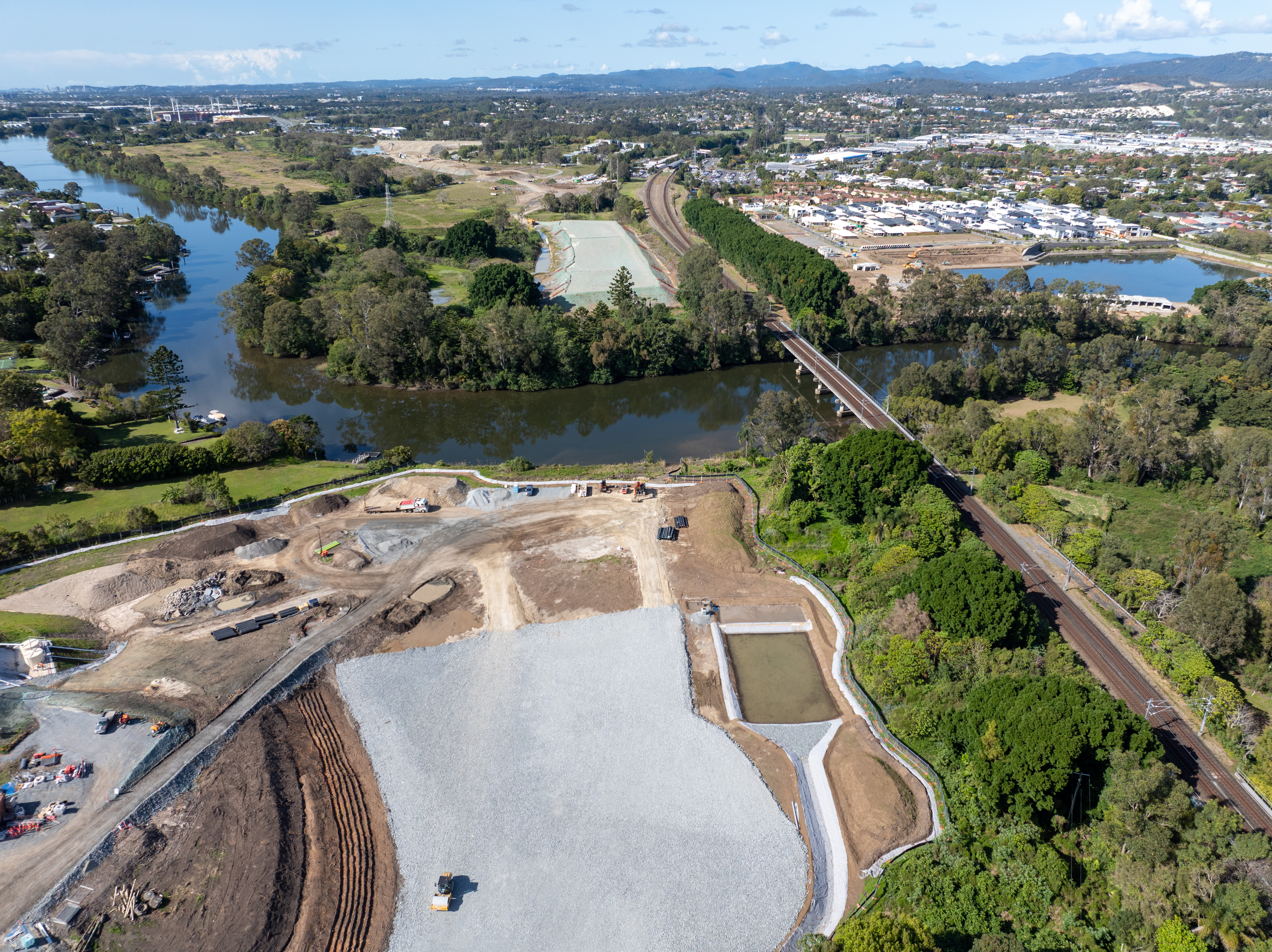
Stage 1 of the Coomera Connector, between Coomera and Nerang, is around 16km and is now open to traffic between Shipper Drive and Helensvale Road.
This project is delivering safety improvements to provide a better driving experience for all road users and aims to reduce the risk of fatal and serious injury crashes.
The project involved upgrading infrastructure to improve safety, provide a better driving experience for all road users and reduce the risk of fatal and serious injury crashes.
The Queensland Government is investigating ways to improve safety for motorists on the D’Aguilar Highway in the Toowoomba Region.
This project involves replacing a failing culvert on Esk-Hampton Road at Perseverance Creek.
The Queensland Government is undertaking an upgrade of the Spencer Street and William Street intersection in Gatton to improve traffic movement, safety and rideability for road users, pedestrians and bike riders.
A large slow-moving landslide is affecting a section of Gatton–Clifton Road at Mount Whitestone.
This planning project aims to develop long-term strategies to manage the impacts of a slow-moving landslide at Mount Whitestone.

Planning is underway to improve flood immunity of Gatton–Esk Road at Lockyer Creek.
Traffic flow and safety has been improved on Gatton–Helidon Road.
The Queensland Government is installing safety treatments to reduce the frequency of vehicle incidents due to driver fatigue.
This project involves safety upgrades to the Gore Highway (Toowoomba – Millmerran) and Toowoomba–Athol Road.
The Queensland Government is improving safety on the New England Highway to reduce the risk of fatal and serious injury crashes for all road users.
The Queensland Government is investigating future road infrastructure requirements to provide a better driving experience for all road users and to reduce the risk of fatal and serious injury crashes.
The Queensland Government is committed to improving safety and efficiency on the New England Highway at Cooyar.
Design is underway to improve safety for people walking and bike riding when crossing at the Chalk Drive, Ruthven and Victoria streets intersection and the Chalk Drive and Neil Street intersection.
The New England Highway Bikeway aims to provide a safe and accessible route for walking and cycling between Highfields and Toowoomba.

The Next Generation Traffic Signalling Program is an initiative aimed at transforming traffic signal infrastructure across Queensland.
Planning is underway for the Pacific Motorway (M1) – Daisy Hill to Logan Motorway upgrade. This section of the M1 cannot accommodate current traffic volumes and, as a result, experiences frequent and prolonged periods of congestion and poor travel time reliability.

Planning and construction is underway for short and long-term upgrades of various interchanges on the Pacific Motorway (M1)
The $1.5 billion Pacific Motorway Varsity Lakes to Tugun (VL2T) project to upgrade 10km of the M1 has been completed.
Work is now complete on the Pacific Motorway, Eight Mile Plains to Daisy Hill Upgrade, which has improved 8kms of the Pacific Motorway (M1) between the Gateway Motorway and Watland Street.
The Exit 49 interchange upgrade has delivered significant improvements in safety and traffic flow efficiency by keeping traffic moving through the improved interchange and reducing queuing.
A separated cycle track is being designed along Taylor Street, between Tor and Boundary streets, as part of the Toowoomba–Cecil Plains Road (Taylor Street) bikeway project.
The Queensland Government has completed the business case for the Toowoomba Central Active Transport Link project.
The Queensland Government has successfully completed the Toowoomba City Cycle Paths project. This project, delivered under the Active Transport Investment Program, has transformed Karrool Street and Goode Street into safer, more accessible, and connected transport routes for pedestrians and cyclists.
The Australian and Queensland governments have worked together to deliver the Toowoomba to Brisbane Passenger Rail Strategic Business Case.
The Australian and Queensland governments worked together to deliver the Toowoomba to Gladstone Inland Rail Extension Strategic Business Case.

The Queensland Government has commenced planning to investigate ways to upgrade Toowoomba–Athol Road (locally known as Anzac Avenue) between and including the Toowoomba–Karara Road (locally known as Wyreema Road) and Boundary Street South intersections.
The Queensland Government is upgrading the intersection of Toowoomba–Cecil Plains, Deuble, and Heinemann roads to meet future transport needs.
Toowoomba-Cecil Plains Road is a critical transport route for the Darling Downs region, connecting agricultural communities to markets and essential services.
The Queensland Government is improving safety along 60km of the Warrego Highway between Toowoomba and Dalby. This includes widening the road, flattening batter/roadside edges, adding new signage and line markings, removing roadside hazards, and installing turning lanes at Speed Road, Oakey.
The Warrego Highway East master plan project will determine the future requirements of the Warrego Highway transport corridor.
Last updated: 12 March 2025