
Bald Hills train station park ‘n’ ride upgrade
Planning works are being finalised to upgrade and expand the southern side of the park 'n' ride at Bald Hills station.
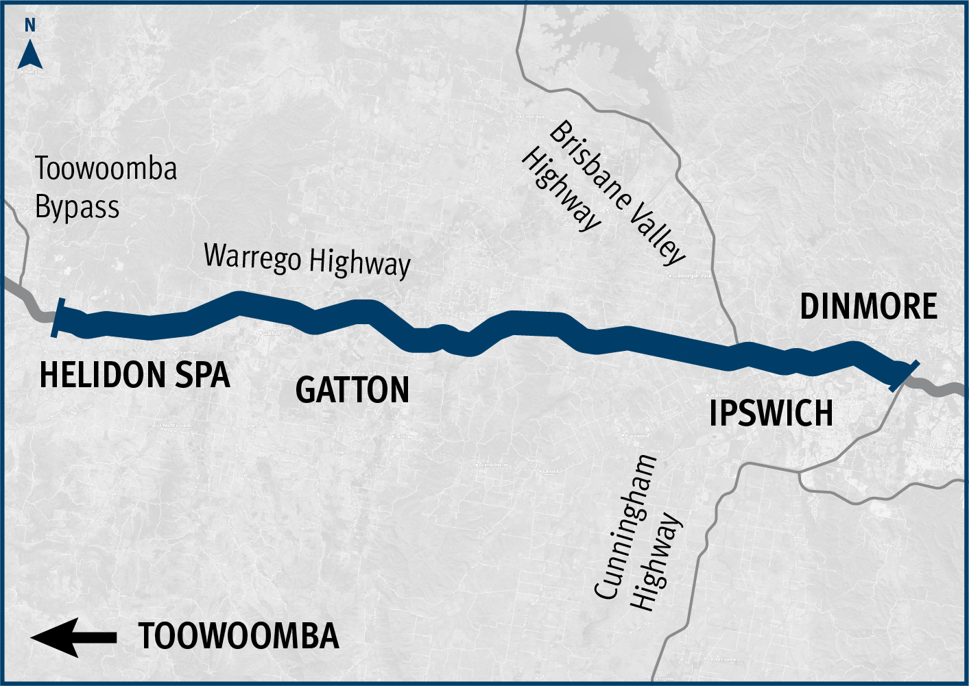
The Warrego Highway forms a critical part of the National Land Transport Network and is Queensland's principal east-west freight route.
The highway connects Darwin and Melbourne to the major import and export hubs of Port of Brisbane, Brisbane Airport, Wellcamp Airport and the future Inland Rail intermodal terminals at Ipswich and Toowoomba.
Infrastructure Australia has recognised the Warrego Highway as a priority initiative on its 2021 Infrastructure Priority List of nationally significant investments, and the highway is part of the nationally accredited Key Freight Route network.
The section of highway between Toowoomba and Ipswich has also been identified as a Road of Strategic Importance by the Australian Government.
The Warrego Highway is a vital transport link for cities such as Brisbane, Ipswich and Toowoomba and the rural communities of the West Moreton, Lockyer Valley, Darling Downs, Maranoa and South West Queensland.
At present the primary drivers of transport needs are:
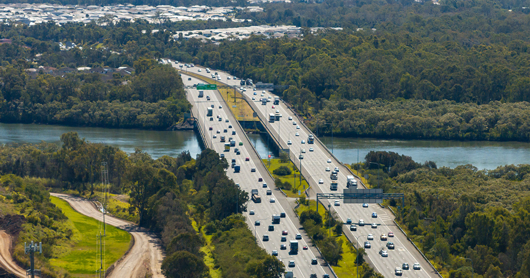
Consequently, the Warrego Highway is one of Queensland's busiest commuter and freight highways in the state. Between Ipswich and Toowoomba there are between 25,000 and 60,000 vehicles per day and up to 20% heavy vehicles. The Warrego Highway Upgrade Strategy (2012) outlines the priority infrastructure projects for the Warrego Highway between Dinmore and Charleville.
Most recently under Tranche 1 of the Warrego Highway Upgrade Program, the East and West Creek culvert upgrades project was finalised, completing delivery of the initial $635 million tranche.
Tranche 2 of the Warrego Highway Upgrade Program included the Toowoomba Bypass which is a 41km alternative crossing of the Toowoomba Range that was completed in 2019.
Tranche 3 includes planning for upgrades between Dinmore and Helidon Spa. Planning is scheduled to occur between 2022 and 2032.
The Warrego Highway funding commitment is jointly funded by the Australian and Queensland governments. Project details and timing subject to further planning and negotiation with the Australian Government, noting the Queensland Government’s initial priority is upgrading the Mount Crosby Road interchange. Investment ID 1202509.
Funding figures as at QTRIP 2023–24 to 2026–27 (June 2023).
Planning works are being finalised to upgrade and expand the southern side of the park 'n' ride at Bald Hills station.

We have investigated safety and congestion improvements for the Banyo level crossing precinct.
The Beams Road rail level crossing project will reduce congestion and address safety concerns. The current rail level crossing on Beams Road will be replaced with an overpass to separate road and rail.
The Queensland Government is delivering the design for an upgraded link for bicycle riders and pedestrians between Kurilpa Bridge and Victoria Bridge on the Bicentennial Bikeway.
The department has completed design of a new rail overpass to reduce congestion and address safety concerns at Boundary Road (Coopers Plains) rail level crossing.
The Queensland Government is upgrading the Bruce Highway, where it joins the Gateway Motorway and Gympie Arterial Road, south of the Pine River to improve traffic flow and safety.

The Queensland Government is upgrading the Bruce Highway (Brisbane-Gympie), Gateway Motorway to Dohles Rocks Road in stages to improve traffic flow and safety.
The Cannon Hill Shopping Centre bus facility is proposed to be upgraded.
The Centenary Bridge Upgrade in Jindalee will upgrade the river crossing from 4 to 6 lanes by building a new 3-lane northbound bridge and rehabilitating the existing bridges to 3 lanes southbound.

The department is undertaking a range of planning activities on the Centenary Motorway between Darra and Yamanto.
The department worked with Ipswich City Council to upgrade the Centenary Motorway exit ramp (Exit 32), and the Main Street and Springfield Greenbank Arterial Road intersection, to manage congestion and improve safety at the exit ramp.
The department is developing a masterplan to upgrade the Centenary Motorway corridor between Darra and Toowong. This initiative aims to improve safety, travel times and meet growing transport needs.

The Queensland Government has improved public transport access and efficiency in Brisbane's northern corridor by delivering the Chermside Bus Layover.
We're upgrading Cleveland-Redland Bay Road, between Anita Street and Giles Road in Redland Bay.
The department is undertaking a $110 million package of works to upgrade Cleveland-Redland Bay Road.
We are investigating safety, accessibility and congestion improvements for the Coorparoo level crossing precinct.

The department is undertaking planning for the remaining sections of the Ipswich Motorway between Rocklea and Darra.
Detailed planning is progressing for an interim safety upgrade and long-term solution for the Cunningham Highway and Ipswich–Rosewood Road intersection in Amberley.
Planning is underway for the upgrade of the Cunningham Highway between Dinmore and Mutdapilly, including Ripley Road and Swanbank Road interchanges.
Planning is underway to upgrade the Cunningham Highway.
Planning is progressing to improve access and create a sense of arrival to North Stradbroke Island (Minjerribah) by upgrading the ferry terminal at Junner Street, Dunwich (Gumpi).
The Eastern Transitway will provide bus customers in Brisbane's east with a safer and more efficient public transport network. The project will deliver targeted bus priority measures to improve safety, reliability, and capacity along Old Cleveland Road from Coorparoo to Carindale.

The Gateway Motorway (Bracken Ridge to Pine River) project is part of integrated planning for the Gateway Motorway and Bruce Highway Upgrades in north Brisbane and the Moreton Bay Region.

Detailed design has started for future expansion of parking facilities at Gaythorne station.

This upgrade is part of the Queensland Government's commitment to improving road safety and traffic flow in the metropolitan region. This project aims to address congestion and enhance safety for all road users.
The Gympie Road Planning Program aims to improve travel from Herston to Carseldine and help prepare Brisbane for the 2032 Olympic and Paralympic Games.
We’re developing a new transport plan for western Brisbane to address traffic congestion, ensure public transport is accessible and reliable, and improve pedestrian and cyclist safety.
We have finalised the Ipswich to Springfield Public Transport Corridor Preliminary Evaluation.
A study has been undertaken to investigate a bypass at Fig Tree Pocket using the existing preserved corridor.
We are working with all levels of government to improve safety and accessibility at the Lindum Station and level crossing.
The Queensland Government is committed to improving road safety, reducing congestion, and supporting the growing needs of the Bald Hills community.
The Manly State Boat Harbour is an integral part of the bayside’s social, cultural and economic landscape. We are currently undertaking a master planning process to help guide future activities at the boat harbour.

Planning to improve active transport infrastructure and safety on Moggill Road between the Centenary Motorway and Kilkivan Avenue, Kenmore is now complete.

In 2021, an upgrade was proposed for the Kenmore roundabout at the intersection of Moggill Road and Brookfield Road in Kenmore. The upgrade proposed removing the roundabout and signalising the intersection, and also included provision for active transport users.

Planning is underway for safety improvements at the intersections of Moggill Road and Brookfield Road and Moggill Road and Kenmore Road, Kenmore.
Planning has been completed to upgrade active transport facilities on Moggill Road, between Witton Road and the Centenary Motorway off-ramp.
Planning to improve safety and congestion at key intersections on Mount Cotton Road, Redland Bay Road and Redland Sub-Arterial Road is complete.

The department is undertaking planning to progressively upgrade the Beaudesert Road corridor, from the Logan Motorway towards Compton Road.
Albion train station will be rebuilt and upgraded to support future interchange demand in Brisbane's inner north.
The Next Generation Traffic Signalling Program is an initiative aimed at transforming traffic signal infrastructure across Queensland.
The department has completed planning which investigated expansion of parking facilities at Northgate station in response to high demand for parking in the local area.
The Australian and Queensland governments are investigating improved freight connectivity to the Port of Brisbane.
Planning to improve safety and congestion at key intersections on Mount Cotton Road, Redland Bay Road and Redland Sub-Arterial Road is complete.
Planning to improve safety and congestion at key intersections on Mount Cotton Road, Redland Bay Road and Redland Sub-Arterial Road is complete.

In April 2019, Fulton Hogan and RoadTek were awarded 5-year contracts to undertake responsive maintenance and road asset management services across the Metropolitan Region.
We are planning for future transport needs between Salisbury and Beaudesert.
Initial community consultation was undertaken on proposed safety and traffic improvement works at key intersections along Samford Road, at Glen Holm Street and Osborne Road.

We conducted a multi-modal study of the ongoing and increasing transport pressures relating to road, active transport and public transport modes in Brisbane’s inner south.
The Queensland Government is planning an upgrade of the Stafford Road and South Pine Road intersection at Everton Park.
The Australian and Queensland governments have worked together to deliver the Toowoomba to Brisbane Passenger Rail Strategic Business Case.
The Veloway 1 (V1) is a dedicated cycleway running between South Brisbane and Underwood. The V1 Birdwood Road velobridge will improve safety, traffic flow and network connectivity.
The O’Keefe Street velobridge at Woolloongabba is now open.

The Veloway 1 (V1) is a dedicated bikeway designed to connect people riding bikes between Lower River Terrace, South Brisbane and Eight Mile Plains, adjacent to the Pacific Motorway.

The Veloway 1 is a dedicated cycleway running between Lower River Terrace, South Brisbane and Slacks Creek. The 20km cycleway provides a safe and efficient route for bike riders.

The department has completed planning to identify a preferred option for the upgrade of the Warrego Highway – Mount Crosby Road interchange.

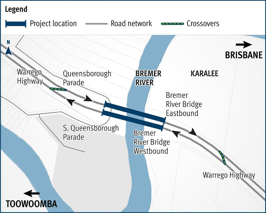
The Bremer River Bridge project involves critical rehabilitation works to extend the life of the existing westbound bridge, and enable removal of the speed restrictions currently in place.
The Warrego Highway East master plan project will determine the future requirements of the Warrego Highway transport corridor.
The Western Brisbane Transport Network Strategy provided a transport vision for developing a fully integrated transport network for western and north-western Brisbane that caters for walking, cycling, rail, bus, roads and freight.
Last updated: 21 May 2024