Coomera Connector

The Coomera Connector (M9) is a 45km north-south future motorway between Loganholme and Nerang, east of the Pacific Motorway (M1) and heavy rail line.

The new motorway will be an alternative to the M1, and support the rapidly growing residential and business communities in the northern Gold Coast and neighbouring Logan areas.

The full corridor extends between the Logan Motorway and Pacific Motorway interchange in Loganholme and Nerang–Broadbeach Road in Nerang.

The Coomera Connector is being delivered progressively:

  • Stage 1 between Coomera and Nerang is being delivered in 3 packages:
    • Stage 1 North: Shipper Drive, Coomera to Helensvale Road, Helensvale
    • Stage 1 Central: Helensvale Road, Helensvale to Smith Street Motorway, Molendinar
    • Stage 1 South: Smith Street Motorway, Molendinar to Nerang-Broadbeach Road, Nerang.
  • Future stages between Loganholme and Coomera, including:
    • Stage 2: between Pimpama and Coomera as the next priority section for planning and design.
Coomera Connector project map including stage 2 project.

Coomera Connector

Video Transcript

The M1 is a key part of Australia’s national land transport network.

Rapidly expanding residential and industrial communities and high levels of projected population growth between Brisbane and the Gold Coast are contributing to the increasing congestion on the M1.

The Queensland Government is planning a new transport corridor that will take pressure off the M1, increasing safety for all road users.

Starting in the south at Nerang Broadbeach Road at Nerang, the new Coomera Connector corridor will be located to the east of the M1 and will travel through the busy growth centre of Coomera and connect with the Logan and Pacific Motorway interchanges.

The corridor will be wide enough for up to 6 lanes of traffic and will include provision for public transport, cyclists and pedestrians.

While still in the early planning phase at present, the Coomera Connector is one of a number of options being considered to address congestion issues on the M1.

The Coomera Connector is expected to play a complementary role to the M1, cutting travel time between Brisbane and the Gold Coast by reducing the number of trips taken on the M1, while also improving connections and providing more transport options for communities in the growing northern Gold Coast corridor.

To find out more about the Coomera Connector, visit tmr.qld.gov.au/coomeraconnector

Benefits

  • Improves safety
  • Increases capacity
  • Improves network efficiency
  • Increases traffic flow
  • Reduces peak hour congestion
  • Reduces interchange queuing
  • Reduces travel time
  • Contributes to economy
  • Better active transport

Key features

  • North-south alternative to the M1 between Loganholme and Nerang, easing congestion from local traffic on the M1.
  • 45km high-speed motorway, located east of the M1 and Gold Coast Heavy Rail Line.
  • 45km walking and bike riding path, with connections to local roads and key community hubs.
  • Additional bridge crossings of the Logan, Albert, Coomera and Nerang rivers, providing crucial alternative crossings to the M1.
  • Wildlife crossings to support safe movement between habitat areas.

Background

The Coomera Connector will be a key link between Loganholme and the Gold Coast, where residential and business communities are growing rapidly.

Since the 1990s, the corridor has been identified in various public planning documents, such as published street directories, regional transport plans, planning studies and City of Gold Coast planning schemes. A joint 2015 study between the Queensland Government and City of Gold Coast confirmed the corridor as a future strategic transport link that will relieve traffic congestion on the M1 and surrounding local roads.

The Coomera Connector was formally declared a future state-controlled road, confirmed in the Queensland Government Gazette in 3 sections, the:

  • Nerang to Coomera section on 18 March 2016
  • Coomera to Stapylton section on 12 May 2017
  • Stapylton to Loganholme section on 15 March 2019.

Three locations have since been identified for corridor amendments to improve outcomes and reduce environmental impacts. These locations are the crossing of the Logan River in Eagleby, Kerkin Road North in Pimpama and Foxwell Road in Coomera.

The changed alignment in Coomera and Eagleby was re-gazetted on 27 June 2025, with the Pimpama corridor amendment to be considered in upcoming phases of the project.

Formal confirmation of the corridor in the Queensland Government Gazette allows the corridor to be protected from new development and provides certainty for property owners, businesses and residential communities on the northern Gold Coast.

Our team continues to liaise with property owners when dealing with land sales and development applications. Early acquisition of properties by the Queensland Government may occur in some circumstances. 

Community consultation

Initial community consultation on the Coomera Connector was undertaken in late 2019.

The consultation program included a series of 10 community drop-in sessions along the 45km project corridor, plus online engagement activities.

There was significant interest from the community with 3200 visits to the website, more than 2000 people visiting the community drop-in sessions, and 700 pieces of feedback received.

A telephone survey of 1000 residents and businesses revealed 4 out of 5 people in the project corridor area support the introduction of the Coomera Connector.

Read the Coomera Connector 2019 community consultation summary.

Further consultation on the whole corridor was carried out in late 2020 and early 2021.

Stage 1 consultation occurred in March 2023 (North package), November 2023 (South package), March 2024 (Central package) and March 2025 (Stage 1 corridor).

Read more about community consultation for Coomera Connector (Stage 1) and Coomera Connector (Future stages) projects.

53 Projects in Coomera Connector

Beaudesert–Beenleigh Road, Milne Street to Tallagandra Road, duplicate to four lanes

This project will duplicate Beaudesert–Beenleigh Road between Mount Warren Boulevard and Tallagandra Road.

  • South Coast District
  • Construction
No image supplied

Beenleigh Connection Road (Logan Street) and City Road, intersection upgrade

The department is planning for a future upgrade of the intersection of Beenleigh Connection Road (Logan Street) and City Road.

  • South Coast District
  • Planning
No image supplied

Beenleigh station precinct upgrade

Beenleigh station is a key transfer location between all-stops and express services on the Beenleigh and Gold Coast train lines.

  • South Coast District
  • Pre-construction
Artist impression of Beenleigh Train station showing carpark, pedestrian overpass and lift and stair access.

Beenleigh–Redland Bay Road, California Creek Road to Mount Cotton Road upgrade, planning

The department has released a planning layout for the Beenleigh-Redland Bay Road (California Creek Road to Mount Cotton Road) upgrade.

  • South Coast District
  • Planning
No image supplied

Bethania station precinct upgrade

The Bethania station precinct is being upgraded to improve accessibility, safety and customer experience.

  • South Coast District
  • Pre-construction

Camp Cable Road and Edelsten Road, improve intersection

This intersection is identified for an upgrade due to the rapid expansion of local urban areas, increased traffic volumes and crash history.

  • South Coast District
  • Completed
Map showing safety improvement works located at the intersection of Camp Cable Road and Edelsten Road in Jimboomba. The northern side of Camp Cable Road will be widened to allow for a dedicated right turn lane into Edlesten Road, so motorists can safely wait before turning, and through-traffic can continue ahead towards Yarrabilba. Camp Cable Road will have new formalised bus stops on both sides of the road along with an extra 2 metres of shoulder width for bicycle riders.  The existing left turn lane from Camp Cable Road onto Edelsten Road will be relinemarked as a shared left turn lane to improve traffic flow. New Stop signs will be installed on Edelsten Road at the intersection replacing the existing Give Way signs.

Coomera Connector (Future stages) Loganholme to Coomera, planning

Coomera Connector (Future Stages), between Loganholme and Coomera, is around 29km and will connect with Coomera Connector Stage 1.

  • South Coast District
  • Planning
Artist impression of the connection to M1 and Logan Motorway.

Coomera Connector (Stage 2), Shipper Drive to Yawalpah Road, planning and design

Stage 2 of the Coomera Connector, between Pimpama and Coomera, is around 5km and is the next priority section for planning and design.

  • South Coast District
  • Planning
Coomera Connector Stage 2 Foxwell Road interchange

Coomera Connector Stage 1 Central

Stage 1 Central of the Coomera Connector is the 8km section from Helensvale Road to Smith Street Motorway.

  • Construction
Construction site of the works happening at Coombabah Creek looking south with building and trees on either side and two sets of train tracks on the right-hand side of the construction site.

Coomera Connector Stage 1 North

Stage 1 North of the Coomera Connector is the 4km section from Shipper Drive to Helensvale Road.

  • Construction
Ariel view of the Coomera Connector highway looking south over Nerang River with paddocks on either side of the highway, residential area across the river with mountain in the background.

Coomera Connector Stage 1 South

Stage 1 South of the Coomera Connector is the 4km section from Smith Street Motorway to Nerang-Broadbeach Road.

  • Construction
Construction site next to Nerang River with train tracks on the right-hand side of the site and building across the river with trees along the river and next to the site.

Coomera Connector Stage 1, Coomera to Nerang

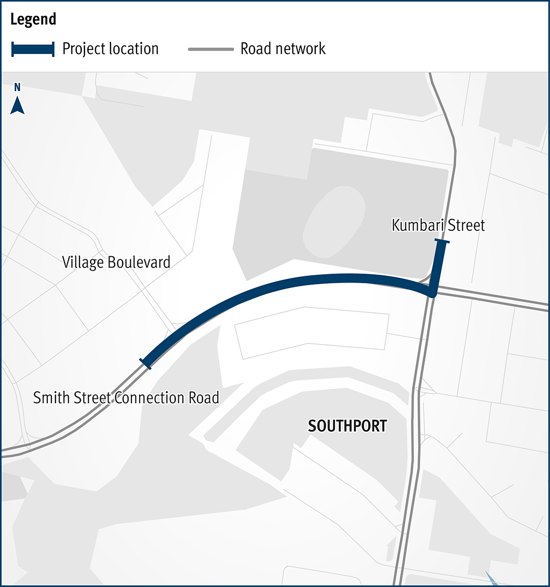
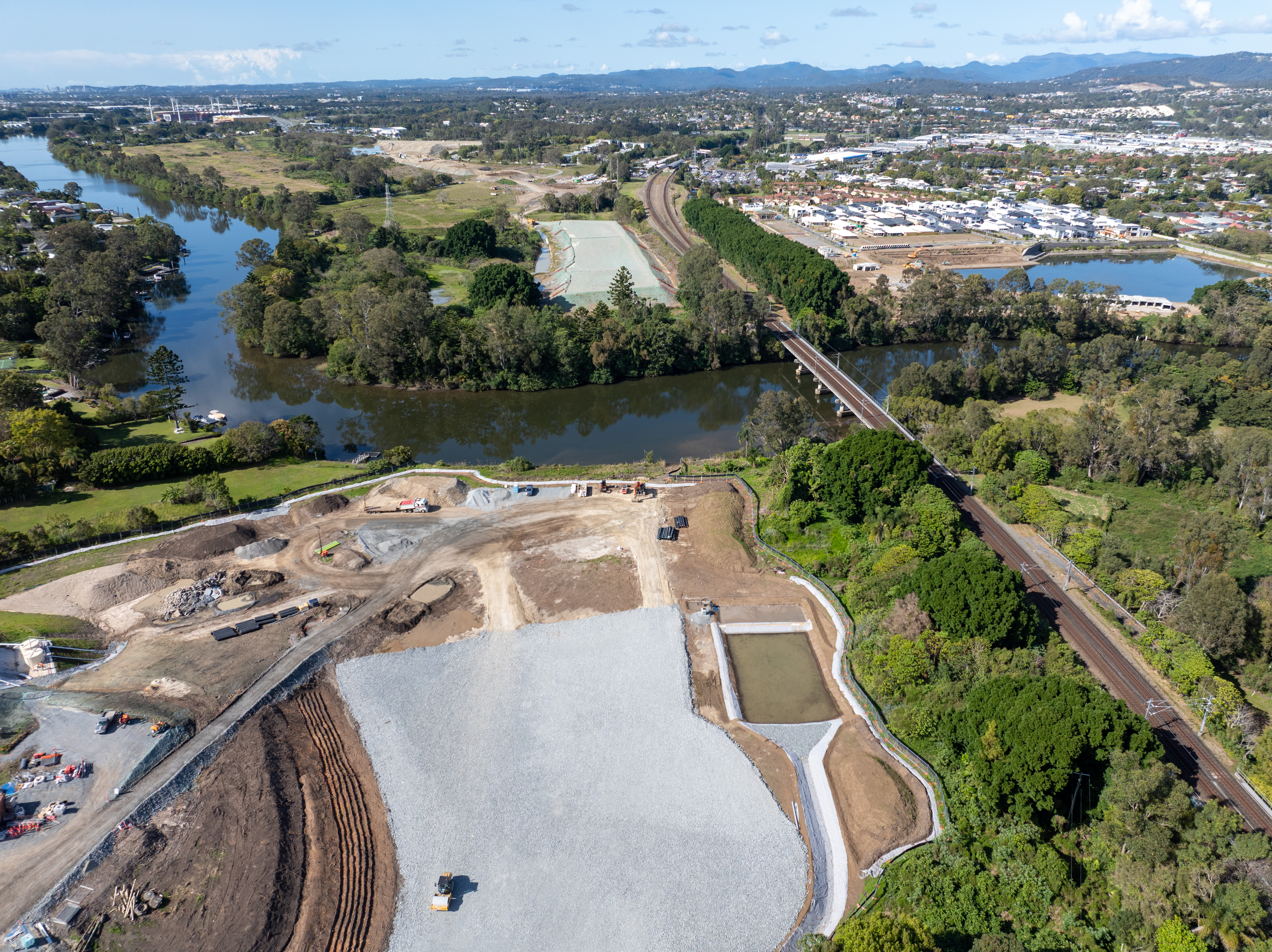
Stage 1 of the Coomera Connector, between Coomera and Nerang, is around 16km and is now open to traffic between Shipper Drive and Helensvale Road.

  • South Coast District
  • Construction
Aerial view of the work being completed on Helensvale Road, Coomera.

Cunningham Highway (Ipswich – Warwick), 2020 Disaster Recovery Funding Arrangements reconstruction works

The department is committed to restoring the damaged section of the Cunningham Highway at Cunninghams Gap. This 2km stretch, leading up to the Allan Cunningham monument, suffered significant road damage during the bushfires in 2019.

  • South Coast District
  • Construction
Aerial image of Cunningham Highway at Cunninghams Gap

Cunningham Highway Upgrade

Planning is underway to upgrade the Cunningham Highway.

  • South Coast District
  • Metropolitan District
  • Planning
No image supplied

Currumbin Creek Road – Bienvenue Drive intersection upgrade

The intersection of Currumbin Creek Road and Bienvenue Drive, at Currumbin Waters will be upgraded.

  • South Coast District
  • Pre-construction
No image supplied

Edens Landing station precinct upgrade

Edens Landing station precinct is being upgraded as part of the Logan and Gold Coast Faster Rail project to improve accessibility, safety and customer experience.

  • South Coast District
  • Pre-construction
People walking along a path with the Edens landing station in the background.

European Train Control System—Beenleigh to Varsity Lakes

The European Train Control System (ETCS) is a digital signalling system being progressively installed to key parts of the South East Queensland (SEQ) rail network.

ETCS plays an important part in the future of our rail network, delivering increased safety, capacity, efficiency, and reliability for a sustainable transport network.

ETCS will soon be installed on the Gold Coast line between Beenleigh and Varsity Lakes stations.

  • South Coast District
  • Construction
No image supplied

Gold Coast Heavy Rail Extension – Varsity Lakes to Gold Coast Airport

We are continuing to protect and plan for the Gold Coast heavy rail corridor between Varsity Lakes and Gold Coast Airport.

  • South Coast District
  • Planning
No image supplied

Gold Coast Highway (Broadbeach to Coolangatta) Currumbin Creek Cycleway, planning

Planning has started on the proposed Currumbin Creek Active Transport Bridge between Palm Beach and Currumbin.

  • South Coast District
  • Planning
No image supplied

Gold Coast Highway (Helensvale - Southport), Pine Ridge Road and Captain Cook Drive, intersection

The department is continuing planning for future upgrades to the Gold Coast Highway at the intersection of Captain Cook Drive/Pine Ridge Road due to the high volume of traffic causing congestion and delays. The future upgrade aims to improve traffic flow and safety at the intersection.

  • South Coast District
  • Planning
No image supplied

Gold Coast Light Rail (Stage 3) Broadbeach South to Burleigh Heads, construct light rail

Gold Coast Light Rail is a world class public transport system for residents and visitors to the Gold Coast.

  • South Coast District
  • Construction
Gold Coast Light Rail Tram with 'Burleigh' destination

Gold Coast Light Rail Stage 4, Burleigh Heads to Coolangatta, planning

The Gold Coast Light Rail is a world class public transport system for residents and visitors to the Gold Coast. The system is being delivered in stages to manage the demands of a growing population and reduce traffic congestion, especially in the southern areas of the Gold Coast.

  • South Coast District
No image supplied

Gold Coast Springbrook Road, Austinville, upgrade causeway, construction

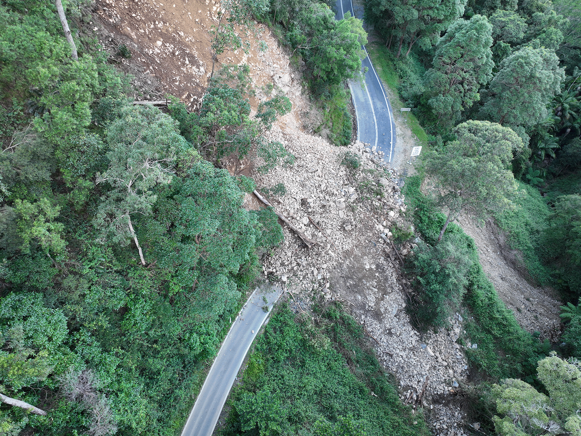
The Mudgeeraba Creek Causeway on Gold Coast–Springbrook Road is being replaced.

  • South Coast District
  • Construction
No image supplied

Gold Coast-Springbrook Road, Disaster Recovery Funding Arrangements reconstruction works

Gold Coast—Springbrook Road sustained a significant number of landslips, rock falls and tree falls during the South Queensland Severe Storms and Rainfall events in December 2023 and January 2024.

  • South Coast District
  • Construction
Aerial view of Gold Coast-Springbrook Road major slip site

Holmview station precinct upgrade

Holmview train station is being upgraded to improve accessibility, safety and customer experience.

  • South Coast District
  • Pre-construction
Artist impression of the Holmview train station from street view looking at the new station entrance.

Kingston station precinct upgrade

The Kingston station precinct is being upgraded as part of the Logan and Gold Coast Faster Rail project to improve accessibility, safety and customer experience for the community.

  • South Coast District
  • Pre-construction
Artist impression of Kingston Train Station following redevelopment

Kuraby station precinct and level crossing upgrade

The Kuraby station precinct is being upgraded as part of the Logan and Gold Coast Faster Rail project to improve accessibility, safety and customer experience.

  • South Coast District
  • Construction

Loganlea station and park 'n' ride relocation

We are relocating Loganlea train station and the park 'n' ride to better connect customers with nearby health, education, and community services.

  • South Coast District
  • Construction
Artist impression of the proposed upgraded Loganlea station. Image is looking from Station Road and shows the new wider underpass with people out the front of the new station building and trains pulled up at the platforms.

M1 Pacific Motorway, Exit 45 (North) Ormeau, design and pre-construction

The M1 Pacific Motorway at Exit 45 (North) Ormeau is experiencing heavy congestion as rapid population growth transforms Ormeau and Pimpama from rural areas into dense urban communities.

  • South Coast District
  • Planning
No image supplied

Nerang to Broadbeach Public Transport Route

We're investigating the east-west public transport route connecting Nerang Station with Broadbeach South. This route will make travel faster, easier and more reliable for communities in the central Gold Coast.

  • South Coast District
  • Planning
No image supplied

Next Generation Traffic Signalling Program

The Next Generation Traffic Signalling Program is an initiative aimed at transforming traffic signal infrastructure across Queensland.

  • Central West District
  • Darling Downs District
  • Far North District
  • Fitzroy District
  • Mackay Whitsunday District
  • Metropolitan District
  • North Coast District
  • North West Direct
  • Northern District
  • South Coast District
  • South West District
  • Wide Bay Burnett District
  • Construction
No image supplied

Ormeau rail facility

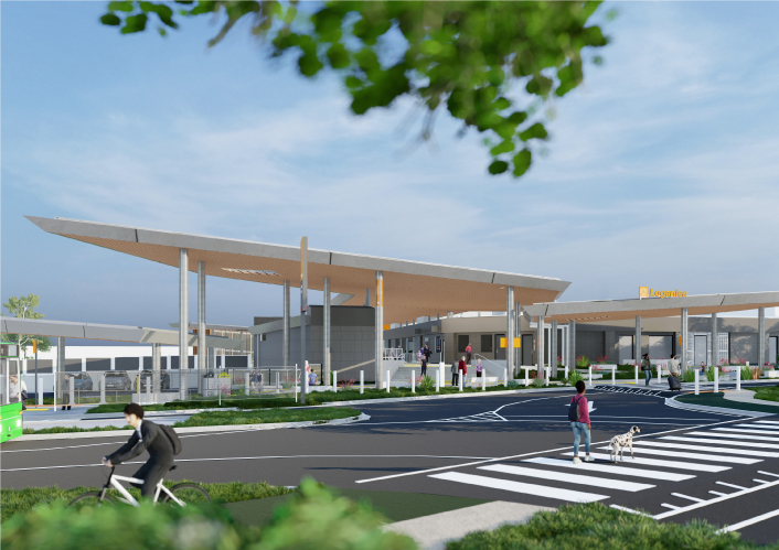
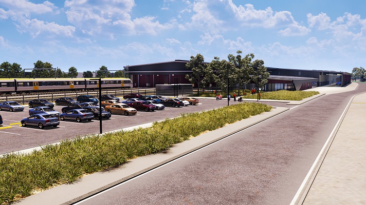
A rail facility is being constructed on a 66ha site in the Gold Coast region.

  • South Coast District
  • Construction
Artist's impression of the Ormeau rail facility

Pacific Motorway (M1) – Daisy Hill to Logan Motorway upgrade

Planning is underway for the Pacific Motorway (M1) – Daisy Hill to Logan Motorway upgrade. This section of the M1 cannot accommodate current traffic volumes and, as a result, experiences frequent and prolonged periods of congestion and poor travel time reliability.

  • South Coast District
  • Planning
Aerial view of Pacific Motorway through Springwood

Pacific Motorway Eight Mile Plains to Daisy Hill Upgrade (Sports Drive to Gateway Motorway Upgrade)

The Sports Drive to Gateway Motorway Upgrade was part of a rolling program of upgrades between the Gateway and Logan Motorways.

  • South Coast District
  • Completed
Aerial of Pacific Motorway looking southbound at Eight Mile Plains

Pacific Motorway Eight Mile Plains to Daisy Hill Upgrade (Watland Street to Sports Drive Upgrade)

The Pacific Motorway (M1) between Watland Street and Sports Drive was upgraded as part of a rolling program of upgrades between the Gateway and Logan motorways.

  • South Coast District
  • Completed
An aerial view of the Pacific Motorway Eight Mile Plains to Daisy Hill upgrade project.

Pacific Motorway M1 Burleigh to Palm Beach (Nineteenth Avenue)

The M1 between Burleigh and Palm Beach (Package B) has been upgraded as part of the Varsity Lakes to Tugun (VL2T) upgrade. Package B included significant environmental features through this section of the upgrade.

  • South Coast District
  • Completed
Pacific Motorway M1 Burleigh to Palm Beach Nineteenth Avenue Exit 89 Tallebudgera interchange

Pacific Motorway M1 Interchange upgrades

Planning and construction is underway for short and long-term upgrades of various interchanges on the Pacific Motorway (M1)

  • South Coast District
  • Planning
No image supplied

Pacific Motorway M1 Palm Beach (Nineteenth Avenue) to Tugun

The Pacific Motorway (M1) has been upgraded between Palm Beach and Tugun (Package C) as part of the Varsity Lakes to Tugun (VL2T) upgrade.

  • South Coast District
  • Completed
Pacific Motorway M1 Palm Beach Nineteenth Avenue to Tugun Currumbin Creek bridge

Pacific Motorway M1 Varsity Lakes to Burleigh

The Pacific Motorway (M1) has been upgraded between Varsity Lakes and Burleigh (Package A) as part of the Varsity Lakes to Tugun (VL2T) upgrade.

  • South Coast District
Image caption: Construction work in progress to upgrade the Burleigh Interchange to a Diverging Diamond Interchange at Exit 87.

Pacific Motorway M1 Varsity Lakes to Tugun upgrade

The $1.5 billion Pacific Motorway Varsity Lakes to Tugun (VL2T) project to upgrade 10km of the M1 has been completed.

  • South Coast District
  • Completed
Aerial view of M1 at Varsity Lakes and Tugun section

Pacific Motorway, Eight Mile Plains to Daisy Hill Upgrade

Work is now complete on the Pacific Motorway, Eight Mile Plains to Daisy Hill Upgrade, which has improved 8kms of the Pacific Motorway (M1) between the Gateway Motorway and Watland Street.

  • South Coast District
  • Detailed design
An aerial view of the Pacific Motorway Eight Mile Plains to Daisy Hill upgrade project.

Pacific Motorway, Eight Mile Plains to Daisy Hill Upgrade (Pacific Highway early works upgrade)

The Pacific Highway (western service road) in Slacks Creek was realigned and upgraded as part of the Pacific Motorway, Eight Mile Plains to Daisy Hill Upgrade.

  • South Coast District
  • Completed
Aerial photo of Pacific Highway early works location

Pacific Motorway, Eight Mile Plains to Daisy Hill Upgrade (Rochedale bus station and park 'n' ride)

The Rochedale bus station and park ‘n’ ride was upgraded as part of a rolling program of upgrades between the Gateway and Logan motorways.

  • South Coast District
  • Completed
Rochedale bus station and park n ride

Pacific Motorway, Exit 49, upgrade interchange

The Exit 49 interchange upgrade has delivered significant improvements in safety and traffic flow efficiency by keeping traffic moving through the improved interchange and reducing queuing.

  • South Coast District
  • Completed
No image supplied

Park Ridge Connector

We are preserving the Park Ridge Connector, a future transport corridor to connect communities planned at Park Ridge, Flagstone and Yarrabilba to services and employment.

  • South Coast District
  • Planning
No image supplied

Road Asset Management Contract and Responsive Maintenance Contract—South Coast

We are delivering continual maintenance and rehabilitation of state-controlled roads and assets in the South Coast region.

  • South Coast District
  • Commissioning
No image supplied

Salisbury to Beaudesert Passenger Rail

We are planning for future transport needs between Salisbury and Beaudesert.

  • South Coast District
  • Metropolitan District
  • Planning
No image supplied

Smith Street Connection Road, Olsen Avenue to Kumbari Avenue, construct cycleway

The Queensland Government has delivered new bicycle facilities to connect to local health, education, business, and tourist areas. 

  • South Coast District
  • Completed
The map shows the locality of the proposed Smith Street Connection Road, Olsen Avenue to Kumbari Avenue, construct cycleway works. Kumbari Avenue is located to the north of the project location in Southport. A solid dark blue line indicates the project extent, which encompasses Smith Street Connection Road west of the intersection and Kumbari Avenue, which is located north and south of the intersection. Village Boulevard is also highlighted on the map, west of the project location.

Southern Queensland 2022 flood reconstruction works completed

Repairs have been completed across southern Queensland after extensive and severe damage to the state-controlled road network was caused by multiple heavy rainfall and flooding events in 2022.

  • Darling Downs District
  • Metropolitan District
  • North Coast District
  • South Coast District
  • Wide Bay Burnett District
  • Completed
Landslip on Gold Coast - Springbrook Road

Stapylton-Jacobs Well Road Upgrade

The department has released a planning layout for the Stapylton-Jacobs Well Road Upgrade.

  • South Coast District
  • Planning
Stapylton-Jacobs Well Road Upgrade

Tallebudgera Connection Road Koala Zone Trial

We are deeply committed to protecting native fauna and actively support initiatives and treatments aimed at reducing koala-vehicle collisions. Recognising our responsibility to safeguard vulnerable wildlife, we prioritise measures that mitigate risks to koalas on Queensland roads.

  • South Coast District
  • Completed
No image supplied

Trinder Park station precinct upgrade

The Trinder Park station precinct is being upgraded as part of the Logan and Gold Coast Faster Rail project to improve accessibility, safety and customer experience.

  • South Coast District
  • Pre-construction
Concept render of the proposed new Trinder Park station showing the Translink logo and Trinder Park sign on the front. Image is looking from Alexander Street with people out the front of the new station building and a train pulled up at a platform.

Woodridge station precinct upgrade

The Woodridge station precinct is being upgraded as part of the Logan and Gold Coast Faster Rail project to improve accessibility, safety and customer experience.

  • South Coast District
  • Pre-construction
Concept render of the proposed upgraded Woodridge station showing the Translink logo and Woodridge sign on the front. Image is looking from Station Road and shows the new wider underpass with people out the front of the new station building and trains pulled up at the platforms.

Last updated: 10 January 2025