
Coomera Connector Stage 1, Coomera to Nerang
Stage 1 of the Coomera Connector, between Coomera and Nerang, is around 16km and is now open to traffic between Shipper Drive and Helensvale Road.
Construction
Stage 1 of the Coomera Connector, between Coomera and Nerang, is around 16km and is now open to traffic between Shipper Drive and Helensvale Road.
Construction
Coomera Connector (Future Stages), between Loganholme and Coomera, is around 29km and will connect with Coomera Connector Stage 1.
Planning
Stage 2 of the Coomera Connector, between Pimpama and Coomera, is around 5km and is the next priority section for planning and design.
PlanningThe Coomera Connector (M9) is a 45km north-south future motorway between Loganholme and Nerang, east of the Pacific Motorway (M1) and heavy rail line.
The new motorway will be an alternative to the M1, and support the rapidly growing residential and business communities in the northern Gold Coast and neighbouring Logan areas.
The full corridor extends between the Logan Motorway and Pacific Motorway interchange in Loganholme and Nerang–Broadbeach Road in Nerang.
The Coomera Connector is being delivered progressively:

The Coomera Connector will be a key link between Loganholme and the Gold Coast, where residential and business communities are growing rapidly.
Since the 1990s, the corridor has been identified in various public planning documents, such as published street directories, regional transport plans, planning studies and City of Gold Coast planning schemes. A joint 2015 study between the Queensland Government and City of Gold Coast confirmed the corridor as a future strategic transport link that will relieve traffic congestion on the M1 and surrounding local roads.
The Coomera Connector was formally declared a future state-controlled road, confirmed in the Queensland Government Gazette in 3 sections, the:
Three locations have since been identified for corridor amendments to improve outcomes and reduce environmental impacts. These locations are the crossing of the Logan River in Eagleby, Kerkin Road North in Pimpama and Foxwell Road in Coomera.
The changed alignment in Coomera and Eagleby was re-gazetted on 27 June 2025, with the Pimpama corridor amendment to be considered in upcoming phases of the project.
Formal confirmation of the corridor in the Queensland Government Gazette allows the corridor to be protected from new development and provides certainty for property owners, businesses and residential communities on the northern Gold Coast.
Our team continues to liaise with property owners when dealing with land sales and development applications. Early acquisition of properties by the Queensland Government may occur in some circumstances.
Initial community consultation on the Coomera Connector was undertaken in late 2019.
The consultation program included a series of 10 community drop-in sessions along the 45km project corridor, plus online engagement activities.
There was significant interest from the community with 3200 visits to the website, more than 2000 people visiting the community drop-in sessions, and 700 pieces of feedback received.
A telephone survey of 1000 residents and businesses revealed 4 out of 5 people in the project corridor area support the introduction of the Coomera Connector.
Read the Coomera Connector 2019 community consultation summary.
Further consultation on the whole corridor was carried out in late 2020 and early 2021.
Stage 1 consultation occurred in March 2023 (North package), November 2023 (South package), March 2024 (Central package) and March 2025 (Stage 1 corridor).
Read more about community consultation for Coomera Connector (Stage 1) and Coomera Connector (Future stages) projects.
The department is undertaking the rehabilitation and maintenance program for the Burdekin River Bridge to preserve the structural integrity of the bridge. The ongoing program will ensure a safe and durable crossing is maintained for the long-term use of vehicles, heavy transport operators, rail operations, bicycle riders and pedestrians.

The Beams Road rail level crossing project will reduce congestion and address safety concerns. The current rail level crossing on Beams Road will be replaced with an overpass to separate road and rail.

This project will duplicate Beaudesert–Beenleigh Road between Mount Warren Boulevard and Tallagandra Road.
The Beerburrum to Nambour (B2N) Rail Upgrade (Stage 1) project will increase the capacity and reliability of the North Coast Line, enabling more efficient travel and improved passenger and freight connections between the Sunshine Coast, Moreton Bay, Brisbane and beyond.

Stage 1 works are underway for an upgrade of the Booral Road and Boundary Road intersection at Urangan.
The Brisbane Valley Highway pavement strengthening project will improve ride quality for motorists.
The department is delivering staged upgrades to manage increasing traffic demands on this section of the Bruce Highway. Stage 1 includes extended north-facing ramps from Dohles Rocks Road to Anzac Avenue.

The Bruce Highway is a critical link for Queensland, connecting coastal and regional communities from Cairns to Brisbane. Safety upgrades are currently underway at various locations, including Station Creek bridge and Boyne River bridge.
The Queensland Government is progressing an $18 million project to upgrade the Bruce Highway at Dallachy Road, near Tully, to improve flood immunity on this section of the highway.
The Queensland Government is implementing cost-effective safety measures to minimise the risk of vehicle and pedestrian incidents, as well as rear-end collisions caused by vehicles turning right across oncoming traffic at this intersection.
The Queensland Government is improving flood resilience across Gulf communities after monsoonal flooding produced widespread impacts across the northern 2-thirds of Queensland in early 2023.
The Cairns Bruce Highway Upgrade master plan was released in 2010. It was the result of a planning study that investigated long term, multi-modal transport planning options to address the impacts of urban growth, congestion and traffic accidents.
The Cape York Region Package Stage 2 is a program of works to deliver infrastructure upgrades on the Cape York Peninsula between 2019-20 and 2024-25.
The Captain Cook Highway is undergoing extensive reconstruction to address the significant damage caused by Tropical Cyclone Jasper in December 2023.
The Carnarvon Highway (Injune - Rolleston), Baffle Creek bridge upgrade project will improve safety and network efficiency by widening the bridge approaches and the existing bridge structure.
The Centenary Bridge Upgrade in Jindalee will upgrade the river crossing from 4 to 6 lanes by building a new 3-lane northbound bridge and rehabilitating the existing bridges to 3 lanes southbound.

The department is improving public transport access and efficiency in Brisbane's northern corridor with the Chermside Bus Layover.
The department is undertaking a $110 million package of works to upgrade Cleveland-Redland Bay Road.
The Queensland Government is upgrading Cloncurry – Dajarra Road to improve the reliability and safety of the Malbon River floodway.
Coomera Connector (Future Stages), between Loganholme and Coomera, is around 29km and will connect with Coomera Connector Stage 1.
Stage 2 of the Coomera Connector, between Pimpama and Coomera, is around 5km and is the next priority section for planning and design.
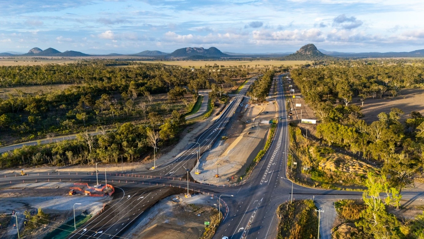
Stage 1 Central of the Coomera Connector is the 8km section from Helensvale Road to Smith Street Motorway.
Stage 1 North of the Coomera Connector is the 4km section from Shipper Drive to Helensvale Road.
Stage 1 South of the Coomera Connector is the 4km section from Smith Street Motorway to Nerang-Broadbeach Road.
Stage 1 of the Coomera Connector, between Coomera and Nerang, is around 16km and is now open to traffic between Shipper Drive and Helensvale Road.
The department is committed to restoring the damaged section of the Cunningham Highway at Cunninghams Gap. This 2km stretch, leading up to the Allan Cunningham monument, suffered significant road damage during the bushfires in 2019.

This project is delivering safety improvements to provide a better driving experience for all road users and aims to reduce the risk of fatal and serious injury crashes.
Safety and reliability on the Diamantina Developmental Road between Dajarra and Mount Isa and Quilpie to Windorah will be improved through a package of targeted upgrades. These will be delivered in sections between 50km and 130km north-west of Dajarra and about 2km north-east of Windorah.
Safety upgrades will be carried out at various locations along Douglas – Garbutt Road.

The Eastern Transitway will provide bus customers in Brisbane's east with a safer and more efficient public transport network. The project will deliver targeted bus priority measures to improve safety, reliability, and capacity along Old Cleveland Road from Coorparoo to Carindale.

This project involves replacing a failing culvert on Esk-Hampton Road at Perseverance Creek.
The European Train Control System (ETCS) is a digital signalling system being progressively installed to key parts of the South East Queensland (SEQ) rail network.
ETCS plays an important part in the future of our rail network, delivering increased safety, capacity, efficiency, and reliability for a sustainable transport network.
ETCS will soon be installed on the Gold Coast line between Beenleigh and Varsity Lakes stations.
Significant progress has been made in restoring roads damaged by Tropical Cyclone Jasper in December 2023.
The cyclone caused severe damage to the state-controlled road network due to record rainfall.

The Queensland Government, via the Department of Transport and Main Roads (TMR), is improving the resilience of the state-controlled road network at priority sites impacted by recent severe weather events.
The project will deliver upgrades to Riverway Drive, between Allambie Lane and Dunlop Street, to improve safety and alleviate traffic congestion.
The Queensland Government is undertaking an upgrade of the Spencer Street and William Street intersection in Gatton to improve traffic movement, safety and rideability for road users, pedestrians and bike riders.
A large slow-moving landslide is affecting a section of Gatton–Clifton Road at Mount Whitestone.
Construction is complete for safety improvements to the Glass House Mountains Road (known locally as Steve Irwin Way) and Caloundra Street intersection, Landsborough.
Gold Coast Light Rail is a world class public transport system for residents and visitors to the Gold Coast.

The Mudgeeraba Creek Causeway on Gold Coast–Springbrook Road is being replaced.
Gold Coast—Springbrook Road sustained a significant number of landslips, rock falls and tree falls during the South Queensland Severe Storms and Rainfall events in December 2023 and January 2024.
Targeted road safety improvements on Goodwood Road will improve the safety of several intersections in Bundaberg and Kinkuna.
The new bridge over Wyaga Creek at Kilbronae has improved flood immunity, safety and efficiency on the Gore Highway between Millmerran and Goondiwindi, which is one of Queensland's most important transport links.
The Queensland Government is installing safety treatments to reduce the frequency of vehicle incidents due to driver fatigue.
This project involves safety upgrades to the Gore Highway (Toowoomba – Millmerran) and Toowoomba–Athol Road.
The Queensland Government is undertaking works to widen and strengthen priority sections of around 9km of the Gregory Developmental Road.
The Queensland Government is undertaking a series of safety improvements along a 40km stretch of the Isis Highway from Airport Drive to the Bruce Highway.
The Queensland Government is improving safety on the Isis Highway between Wyper Park and Willdora Drive.
Significant progress has been made on restoring the Kennedy Highway (Kuranda Range Road) to its pre-event function following Tropical Cyclone Jasper in December 2023 and the North and Far North Tropical Low in February 2025.
The Kuraby station precinct is being upgraded as part of the Logan and Gold Coast Faster Rail project to improve accessibility, safety and customer experience.

We are relocating Loganlea train station and the park 'n' ride to better connect customers with nearby health, education, and community services.
The upgrade of the Maryborough - Hervey Bay Road and Pialba - Burrum Heads Road intersection in Eli Waters will improve traffic movement and the safety of motorists, pedestrians and bike riders.
Construction has started on the Mooloolaba Road, Syd Lingard Drive to Tantula Road West intersections upgrade project. This project is designed to improve traffic flow and reduce delays, congestion, and queuing in this busy area.
The Mooloolah River Interchange Upgrade project will address long-standing safety and congestion issues on the Sunshine Motorway, with the Sunshine Coast experiencing rapid population growth and development.
This project is critical to improving north-south road connectivity and is a key component of The Wave – a broader plan to deliver generational infrastructure for the region.
Reconstruction works are underway on a section of Mossman – Daintree Road damaged during ex-Tropical Cyclone Jasper.
Disaster recovery is a long-term process and involves an extensive program of works and complex solutions.
A variety of stabilising techniques will be used, including:
These repairs will ensure the road is returned to its fully operational pre-cyclone function.
Reconstruction works on Mossman – Mount Molloy Road are underway to repair landslip sites caused by ex-Tropical Cyclone Jasper in December 2023.
The Queensland Government is repairing Mount Spec Road after substantial structural damage following record rainfall in early 2025. This includes more than 60 landslips, with 6 major and 2 high-risk sites.
The Queensland Government is expanding the parking facilities at Narangba train station.
The Queensland Government is improving safety on the New England Highway to reduce the risk of fatal and serious injury crashes for all road users.
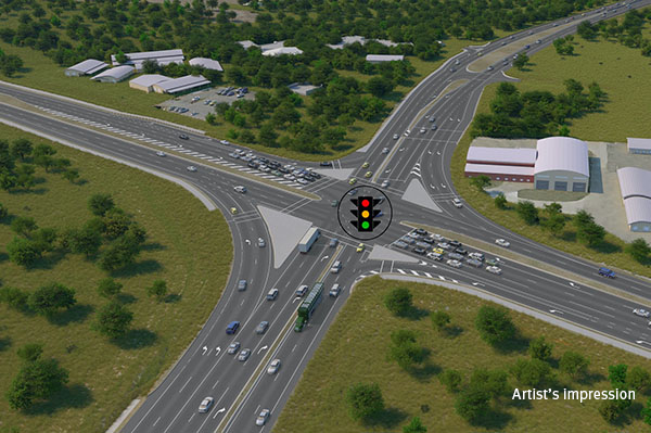
The Next Generation Traffic Signalling Program is an initiative aimed at transforming traffic signal infrastructure across Queensland.
Safety upgrades will be carried out at various locations along North Ward Road.

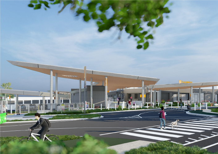
A rail facility is being constructed on a 66ha site in the Gold Coast region.
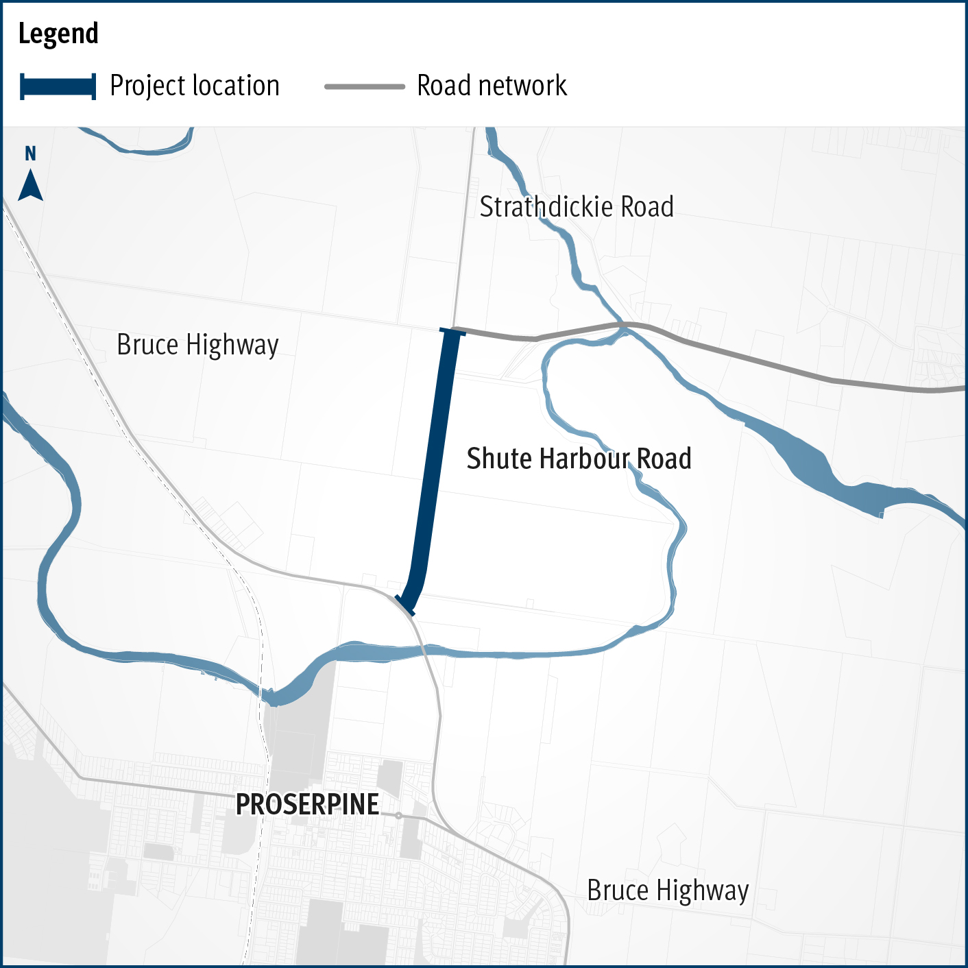
Upgrades to this key arterial road in the Whitsunday Region include flood immunity improvements at Hamilton Plains and a capacity upgrade between Paluma Road and Valley Drive in Cannonvale.
We own and maintain over 430 pieces of marine infrastructure valued at about $153 million. These include assets such as state boat harbours, boat ramps, jetties, pontoons, floating walkways, channels, and breakwaters/rock groynes.
The Rockhampton Ring Road is a transformative project for the Bruce Highway, designed to support future economic growth and deliver key benefits such as improved flood resilience, freight efficiencies, reduced travel times and enhanced road safety.
Rockhampton-Yeppoon Road is a regional road linking the Capricorn Coast, including tourist locations, such as Great Keppel Island to Rockhampton and beyond.
The Queensland Government has successfully completed the Toowoomba City Cycle Paths project. This project, delivered under the Active Transport Investment Program, has transformed Karrool Street and Goode Street into safer, more accessible, and connected transport routes for pedestrians and cyclists.
Toowoomba-Cecil Plains Road is a critical transport route for the Darling Downs region, connecting agricultural communities to markets and essential services.
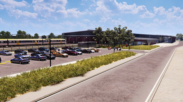
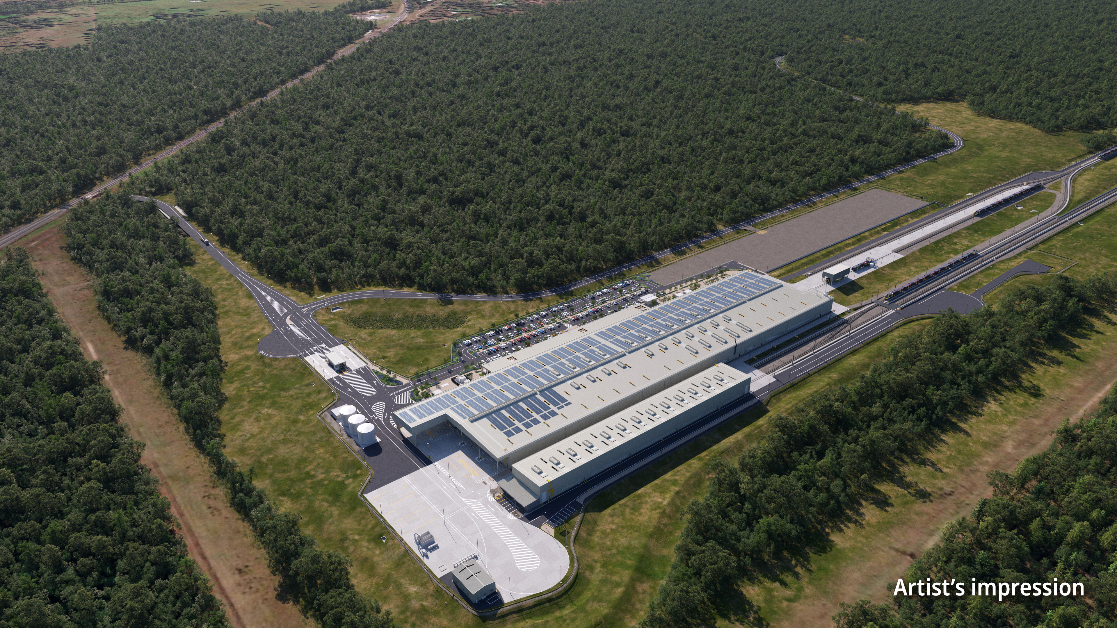
A new facility is being constructed in the Fraser Coast region, to manufacture the Queensland Train Manufacturing Program fleet.
The Queensland Government is duplicating the Bowen Road bridge to improve safety, capacity, and reliability for road users crossing the Ross River in Townsville.
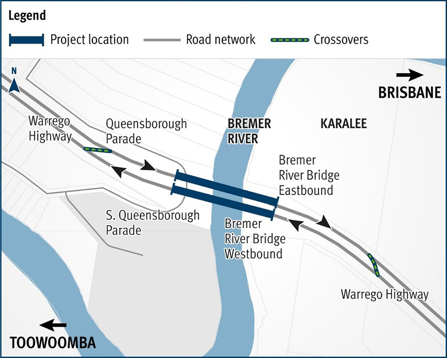
The Bremer River Bridge project involves critical rehabilitation works to extend the life of the existing westbound bridge, and enable removal of the speed restrictions currently in place.
The Queensland Government is improving safety along 60km of the Warrego Highway between Toowoomba and Dalby. This includes widening the road, flattening batter/roadside edges, adding new signage and line markings, removing roadside hazards, and installing turning lanes at Speed Road, Oakey.
Last updated: 10 January 2025